Scrappy surf ahead, with brief windows for frothers

Sydney Hunter Illawarra Surf Forecast by Ben Matson (issued Wed Dec 13)
Features of the Forecast (tl;dr)
- Easing S'ly swell and a small NE swell Thurs with early light winds
- Small weak surf over the weekend, early light winds
- Small swell sources for much of next week
Recap
Much of Tuesday saw small leftovers though the South Coast delivered an afternoon pulse in new long period southerly groundswell. This energy has shown across all areas today, with 4-5ft sets across most south facing beaches, bigger surf at the offshore bombies but smaller waves inside southern ends. Winds were light and variable early, but are now freshening from the NE so conditions are bumpy. Surf size is also slowly tapering off.
This week (Dec 14 - 15)
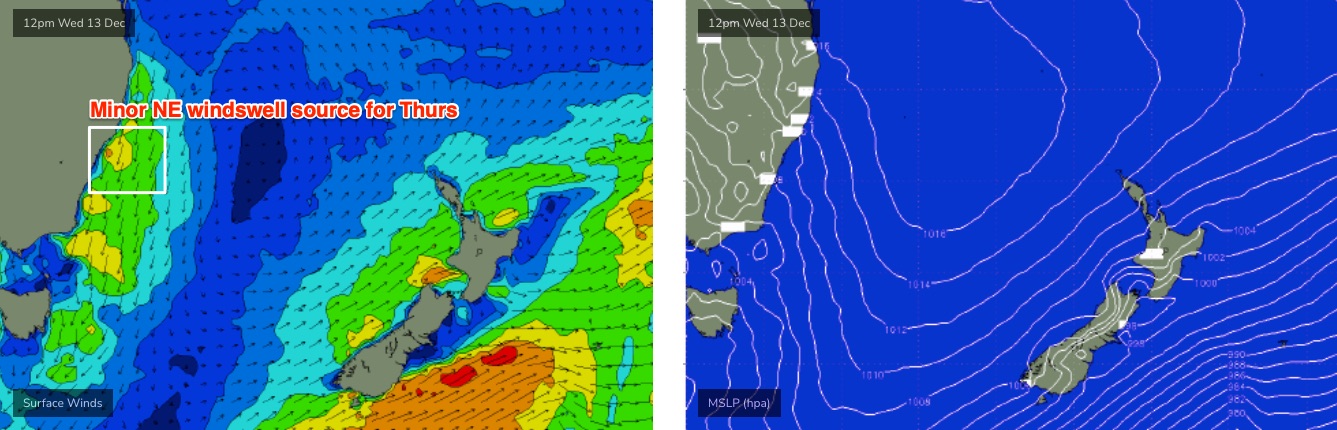
Easing southerly swells will dominate tomorrow, and we’ll also see a small level of local NE windswell thanks to this afternoon’s developing breeze. Size will probably max out around the 2-3ft mark at most open beaches, and conditions should be clean under early light NW winds. We may see a few bigger lingering sets across the Hunter (from the south) in the morning.
Weak NE sea breezes will accompany a slow drop in size from both sources into the afternoon.
Overnight on Thursday, a trough push across the region, bringing a short lived but occasionally gusty S’ly change. It should be into the South Coast late afternoon, the Illawarra early evening, Sydney mid-late evening and the Hunter around midnight.
On Friday, we’re looking at small residual leftover swells with lingering S’ly winds across many spots, perhaps SW in a few areas if we’re lucky.
During the day (early morning on the South Coast), a small long period S’ly groundswell is expected to make landfall generated by a trailing front in the Southern Ocean earlier this week. There won’t be a lot of size on offer, but more defined 2ft sets should show at south facing beaches into the afternoon, maybe some 2-3ft sets at some of the more reliable swell magnets (i.e. Hunter).
Weak sea breezes are expected by this time so surface conditions won’t be perfect, but the should be small waves on offer.
This weekend (Dec 16 - 17)
Still not much on the cards for the weekend.
Inactive swell windows through the end of this week will ensure small surf prospects for both Saturday and Sunday, only favouring the swell magnets with slow 1-2ft sets.
Winds should be light and variable early Saturday before a shallow southerly change pushes up the coast into the afternoon. It’ll dissipate overnight, leading to a similar morning of light winds on Sunday before afternoon sea breezes redevelop after lunch.
Next week (Dec 18 onwards)
Persistant troughiness will linger across the coastal margin for much of next week, but there’s still no sign of any major swell generating systems.
A weak low may form off the North Coast on Sunday, allowing minor E/NE swells to show on Monday, and a broadening trough off the South Coast around Tuesday could lead to mid-range SE swells building later Wednesday or Thursday.
Additionally, we have some developing trade flow out near Fiji for the long term but no major size is expected from this region either.
All in all, the lead up to Xmas is looking a little on the small side. But I’ll have more on that in Friday’s update.
Comments
An hour or so today was easy 2x + up the Nth end of the beach. Completely straight everywhere but real size.
Strong westerlies here this arvo. Conditions awesome. Just not a lot of swell here as it’s in a bit of a S swell shadow.
Coupla gnarly fires across the Hunter right now. The Abermain fire (Cessnock Rd, Emergency Warning) has 200 firefighters on scene, temps are 38 degrees and winds have been gusting almost 40kts W/NW.
what's the call on any small but long period South swell being generated now for Sat/Sun from that low zipping through down in the 50's latitude tonight and Friday? looks like it is forecast to pass through pretty quickly and not a heap of fetch.