Strong from the south, then from the east

Sydney Hunter Illawarra Surf Forecast by Ben Matson (issued Fri 9th Dec)
Forecast Summary (tl;dr)
- Large S'ly tending S/SE swell on Sat with light variable winds and sea breezes
- Easing S'ly swell and early ligh winds Sun
- Fun peaky NE windswell Mon with an a'noon W'ly change creating clean conditions
- Small S'ly swell late Turs/Wed
- Strong E/NE groundswell showing Thurs, building Fri, peaking Sat, easing Sun
Recap
Easing S'ly swell managed clean 3ft sets Thursday morning before gusty southerly winds kicked in, and a new S'ly swell built to 4ft through the afternoon, increasing further to 4-6ft at south facing beaches this morning under generally moderate to fresh S/SE winds. The acute swell direction (in fact, peak energy is slightly west of south at the Sydney buoy, see below) has resulted in significantly smaller surf at locations not exposed directly to the south.

This weekend (Dec 10 - 11)
The low generating this current event is parked midway between Tasmania and New Zealand, and southerly gales around its western flank reached maximum strength around lunchtime today.
This energy will fill in overnight and hold across Southern NSW on Saturday; the main difference between today and tomorrow will be a longer wavelength, a higher consistency in the sets, and a slight swing in the direction from the S to the S/SE as the day wears on, which will favour a few more beaches than today with bigger surf.
More importantly, local winds will throttle back and become light and variable tending offshore as a weak ridge settles across the coast. This will create clean conditions pretty much everywhere.
Size should manage 5-6ft at most south facing beaches, though regional swell magnets such as the Hunter and local offshore bombies should see occasional 6-8ft bombs. As per usualy, beaches not open to the south will be a lot smaller.
On Sunday, surf size will slowly ease from 4ft+ at south facing beaches at dawn, down to 2-3ft during the day (smaller elsewhere as per the usual caveats), and early light NW winds will clock around to the NE and freshen into the afternoon. So, make it early for the best waves.
Next week (Dec 12 onwards)
Monday looks fun.
We'll see a small level of residual S/SE swell in the water, but the main energy will be peaky NE windswell sourced from the local fetch kicking up late Sunday. This should provide peaky 2-3ft sets to north and east facing beaches, and a W'ly change pushing through around lunchtime should swing the breeze from pre-dawn N'lies to the N/NW before tending fresh W'ly in the early afternoon (timing needs to be a little flexible right now, I'll update over the weekend if there are any major changes).
We'll then see a small S'ly swell glance the coast late Tues and into Wed from W/SW gales exiting eastern Bass Strait (associated with Monday's change), and there's potential for a few small peripheral south swells later in the week from poorly aligned fetches south from Tasmania.
But the real juice is lining up from the E/NE later next week.
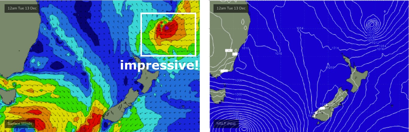
On Sunday, a deepening tropical low south of Fiji will work together with a broad ridge to its south-east (thanks to a broad high east of New Zealand), strengthening an impressive fetch between the two - see below - that'll generate some impressive groundswell that's expected to first show across the region on Thursday, building steadily on Friday, reaching a peak on Saturday before gradually easing from Sunday.
At this stage the fetch looks capable of a peak around 4-6ft somewhere across the East Coast though we'll need to fine tune the specifics next week.
Have a great weekend, see you Monday!
Comments
It’s taken a while but those plots are a lot more reliable, someone must’ve updated the code.
Bloody hope so.. been a little off lately
I guess we got skunked on the NE swell
Think so or at least it’s going to be overwhelmed by south swell and be one big shit close out
Groundswell can wrap better than windswell
What’s the threshold for calling something a ground swell? Fetch, period, size, distance travelled ?
Genuine question we use the term “groundswell” but what does that mean ? (Apart from solid waves! )