Small spell of waves ahead

Sydney Hunter Illawarra Surf Forecast by Ben Matson (issued Wednesday 15th Dec)
Forecast Summary (tl;dr)
- Small renewal of SE swell Thurs, get in early north of Sydney before S'ly winds bump things up (breezey conditions expected by dawn, south of Sydney)
- Another SE swell and a small S'ly swell Fri, with better, improving morning conditions (south of Newy)
- Building NE windswell Sat, but bumpy; low chance for early window of light winds and small leftovers
- NE windswell showing best early Sun with light morning winds
- Not much on the long term radar
Recap
Monday’s solid SE swell eased steadily through Tuesday (3-4ft) and today (2ft+), with early winds being light, creating clean conditions. Light to moderate SE sea breezes Tuesday afternoon and moderate to fresh NE sea breezes Wednesday afternoon have created bumpy conditions after lunch both days.
This week (Dec 16 - 17)
So, the weekend’s Tasman Low event - responsible for the last six days of swell - has become absorbed into a broad trough occupying the eastern half of the Tasman Sea.
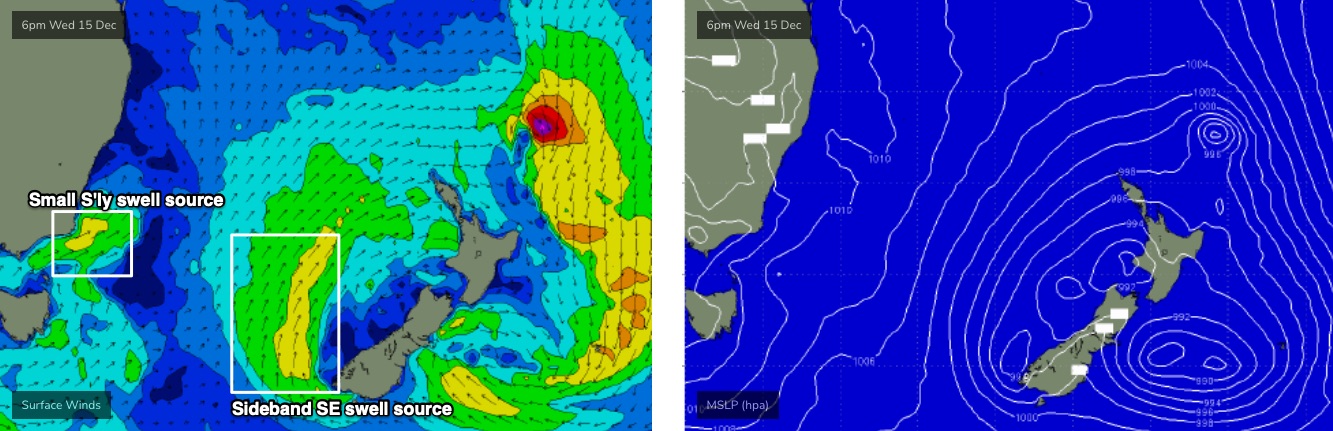
A couple of fetches have developed on its southern and western flank, generating a couple of sideband SE swells that will glance the coast on Thursday and Friday. The first swell (Thurs) won’t have a lot of size, but should see inconsistent 2ft sets at most open beaches through the day, with rare 2-3ft sets at the swell magnets. It'll be smaller at beaches not open to the south.
Unfortunately, a shallow southerly change is expected to push along the coast through the morning, probably reaching the Illawarra before dawn, nosing into southern Sydney around dawn, then the Central Coast early-mid morning and the Hunter mid-late morning.
Point being: south of Sydney will become blown out very early, but there’s a window of opportunity north of Sydney. Be quick for the best waves - and let’s hope the new energy kicks in by then too, it’s not a given, actually - the swell front’s due in around 7-8am, give or take a few hours.
A reasonable fetch trailing Thursday’s change will be strongest as a SW airstream exiting eastern Bass Strait (see below), and this should contribute a secondary S’ly swell on Friday, in addition to another, better SE swell from a fetch developing today off the SW tip of New Zealand’s South Island (see below).
So, the two swells should produce 2-3ft+ waves at south facing beaches, maybe the odd bigger set across the Hunter, and conditions should improve quickly as light variable winds set in across the coast ahead of freshening NE breezes into the afternoon.
The only exception here is the Hunter which may see lingering S/SE winds from Thursday creating lumpy, leftover conditions for a few hours - the middle of the day may be a better option north of Sydney.
This weekend (Dec 18 - 19)
No change to the weekend outlook.
Saturday looks average with freshening NE winds and building local NE windswells (and, an easing combo of S’ly and SE swells from Friday). Northern corners may offer a brief window of small leftover surf and temporary N/NW winds - mainly north from Sydney - but it won’t last long and most beaches will become blown out during the day.
The NE windswell should reach 2-3ft by Sunday morning, and a weak trough pushing in from the south will create lighter winds around dawn, resulting in a gradual improvement through the morning. Surf quality won’t be especially high but there’ll be waves on offer for the second half of the weekend.
I'll firm up the specifics on Friday.
Next week (Dec 20 onwards)
The long term looks a little drab.
A bunch of potential swell sources developing on the periphery of our various swell windows look like they’ll create small flukey surf at best. They include a powerful polar low well south of Tasmania on Saturday (minor S’ly groundswell early next week), a vigorous but narrow front south of Tasmania on Sunday (same), and a small E’ly dip south of Fiji over the weekend (minor E/NE swell potential).
And, we’ll see some more local mid-week NE windswell in response to freshening winds off the NSW coast.
All in all, make the most of what you see, the long term outlook ain’t special.
See you Friday.
Comments
Six days of waves pretty darn good for December in my book
and Hawaii has been ordinary how good is that.
An ordinary day in Hawaii is still better than a good day here!
Still pretty calm in the 'Gong as i type this
'Tis a weird one, and I wonder if last night's impressive thunderstorm disrupted proceedings.
Fresh S'ly winds in the lee of the shelf cloud swung back light W'ly overnight across many coasts, but winds have already gone S/SW in Newcastle (4:30am), Norah Head (6am), Northern Beaches and Little Bay (3am) - i.e. all over the shop - and without any major strength.
Seems to be light and variable down to about Ulladulla where S/SE winds have been freshening for the last few hours. Montague Island's been gusting 20kts since about 4am, but mainly SW winds at Green Cape overnight have gone more W/SW in the last hour or so, and Gabo Island is back to the west!
Curve-ball-o-rama.