Patchy outlook for the next few days; windows of opportunity from Thursday

Sydney Hunter Illawarra Surf Forecast by Ben Matson (issued Monday Dec 6th)
Forecast Summary (tl;dr)
- Small average surf for the next few days
- Chance for a late window of light winds late Thurs, with building sideband SE swell from a trough off the Far South Coast
- Building combo of SE and S'ly swells on Fri, and early SW winds tending gale force S'ly
- Sat/Sun: easing SE swells with moderating S'ly winds
- Mon: good SE swell with light winds
- Long range: are the tropics about to fire up?
Recap
Tiny conditions on Saturday increased from the south on Sunday as a southerly swell built across the coast, accompanied by fresh winds from the same direction, creating poor conditions. Size eased a little more today but winds have eased back a touch and swung more easterly. Another day of mediocrity across most of Southern NSW.
This week (Dec 7 - 10)
Jumping back onto the forecast bench as Steve’s away on leave, and it looks like the small east swell for tomorrow has been downgraded.
We have seen some fun surf across Northern NSW today from a stalled trough in the lee of Saturday’s late southerly change, but the fetch hasn’t really orientated itself within Southern NSW's swell window, and therefore the only source of energy is a weak right through the central Tasman Sea.
Max surf size across Southern NSW for the next few days will probably be around the 2ft mark, with smaller surf likely south of Sydney. Light winds early Tuesday will swing into an afternoon nor’easter, ahead of a fresh southerly change pushing up the coast on Wednesday. A local windswell is likely to build at south facing beaches through Wednesday afternoon but quality won’t be very high under the southerly breeze.
Thursday and Friday look interesting.
A stalled trough off the coast is expected to muscle up through Thursday (see below), strengthening E/SE winds into the Far South Coast, before a Tasman Low forms along the trough line overnight Thursday, and drives southerly gales across all Southern NSW coast regions into Friday morning.
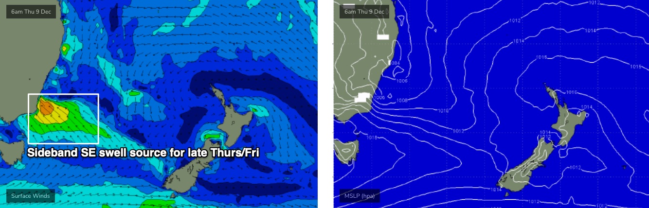
Prior to the southerly change, we may pick up some good waves on Thursday afternoon, north of about Ulladulla. The axis of the trough looks to be positioned about here, meaning locations to the south will probably be wind affected but locations north should see clean conditions under light variable breezes.
Additionally, we’ll see sideband SE swell spread north of the main E/SE fetch (aimed point-blank into the Far South Coast) and there’s a chance for a late session as the swell builds but before the low started to affect local surface conditions.
It’s hard to have confidence on size though, because locations closer to the South Coast will see more size than locations further north. Let’s ballpark late 2-3ft sets in Sydney, smaller to the north, but bigger across the Illawarra in the 3-4ft range (bigger but more wind affected down south). Expect small residual surf in the morning before the new swell fills in.
Of course, small changes in the position of the trough could affect this outlook so check back on Wednesday.
Friday then looks to see a combination of sideband SE swell plus building local S’ly windswell, but with accompanying SW tending S’ly gales as the low pushes off the coast. Friday afternoon should be north of 6ft at south facing beaches but it’s quite likely conditions will be very wind blown at that point, so protected southern corners will be your best option.
For the record, Late Thursday and Friday will also see some small long period south swell in the mix from a low traversing the waters below Tasmania late Tues/Wed, but it’ll be hard to detect in the mix.
Lastly, a large sub-tropical low well north-east of New Zealand at the moment is generating some long range E'ly swell that shiuld filter into Southern NSW mid-late this week, though it'll be only small in size and undetectable beneath the primary energy.
This weekend (Dec 11 - 12)
Friday’s Tasman Low will dominate surf conditions into Saturday, with large, windy swells easing and abating through the day. The low will gradually retreat into the Tasman Sea meaning surf size should ease only slowly rather than steadily.
Early estimates are for 6ft+ sets at south facing beaches, easing to 3-5ft by Sunday, when conditions will be more manageable under light to moderate SW tending S’ly winds. Saturday likes a little wild and wooly at this stage but there will certainly be plenty of waves around.
There'll also be some easterly groundswell in the mix both days, originating from the subtropical low in the South Pacific mentioned above. Size won't reach much more than an inconsistent 2-3ft, and it'll be impossible to detect in the mix, but it'll be there.
Next week (Dec 13 onwards)
Current expectations are that the Tasman Low will persist for a little while, keeping the first half of next week flush with SE swell in the 3-5ft range. In fact, this looks to offer the best waves of this particular swell cycle, as winds should become light and variable by this point.
A series of polar fronts skirting the ice shelf from this Wed/Thurs onwards will also provide a small undercurrent of southerly swell for the first half of next week too. But it’s not worth worrying about.
Surf size will then gradually ease through the rest of next week, with no significant events on the radar beyond this right now.
However, there is some interesting tropical activity pegged for the Coral Sea next weekend that could lead to NE swell potential mid-late next week through next weekend and onwards.. certainly quite speculative at such long range, but worth flagging as it’s that time of the year where the tropics start to fire up.
See you Wednesday!
Comments
What happened to all the waves on the models for the weekend?
GFS pushed the trough/low far south. Has come back a bit more into line with EC this morning though and has it back a bit further north.
Any waves for Xmas period on the forecast or to early to call yet??
Next week is starting to look like a fun week particularly towards the end. Fingers crossed.