Solid surf on the way

Sydney Hunter Illawarra Surf Forecast by James Casey (issued Wednesday 5th May)
Best Days: Saturday and Sunday
Outlook:
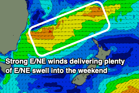
- Today will see the start of an easterly trough low form off the east coast and provide plenty of swell out of the E/NE from Thursday until Sunday
- E/SE winds will make Thursday and Friday a bit wild with a window late on Friday
- Winds will swing offshore for Saturday, with plenty of swell it’ll be the pick of the week ahead
- S winds for Sunday will mean southern corners pick up the most of the E/NE swell and have clean conditions
- A new S swell will combine with an E trade swell to keep wave heights around 3ft for the start of next week
- The E trade swell will keep waves up around the 3ft mark further ahead
Recap
Waves yesterday morning were small but surfable in that 2ft+ range with the E/NE swell but a S swell moved in late yesterday afternoon providing some 2-3ft+ sets, biggest at S swell magnets.
Due to the vast distance this S swell travelled it completely slipped through the net as I focussed on the dynamic low much closer to our coast. The S swell was the same that hit SW Western Australia for the WSL and continued east with strong winds whipping up a large swell for Victoria and now a more modest swell for us on the east coast.
Winds were light and variable offshore for most of the day, swinging between NW and SSW with rain preventing winds from getting too strong. Conditions were mainly clean and peaky with the two swells in the water.
Conditions are similar this morning 2-3ft in Sydney and the Illawarra and more like 3ft for the Hunter. Winds are light and offshore so expect some nice peaks to be had.
The end of this week
The region of low pressure will intensify as the day goes on today with winds building out of the S/SE as the day goes on. Expect this morning's light W winds to swing around to the SW and then SE with the Illawarra to have strong SE winds by the late morning, Sydney by the middle of the day and the Hunter by late afternoon.
 The strengthening of these winds is in line with the formation of the easterly trough low. Expect the stronger SE winds to whip up some additional SE windswell before the larger E/NE swell begins to fill in tomorrow. Waves will remain in that 2-3ft range, up around 3ft+ for the Hunter.
Larger waves will fill in tomorrow as a mid period E/NE swell forms thanks to persistent strong winds on the southeastern flank of the low. It will build rapidly throughout the day finishing up around the 6ft+ mark by the afternoon, biggest for the Illawarra closer to 8ft Unfortunately winds will be out of the S/SE in the morning before strengthening out of the E/SE from the mid morning making a mess of things for most of the day.
Strong winds on the southeastern flank of the low will have already created the largest of the swell though as we see it peak up around the 6-8ft+ mark in the morning on Friday, closer to 8ft+ for the Illawarra, although with the SE winds there won’t be too many clean options. The low will start shifting south and east on Friday allowing the strong E/SE winds to gradually subside and SW winds to slowly clean things up for the afternoon and into the weekend.
The Weekend
Saturday is looking to be the day with waves still solid and winds swinging offshore for the morning as the low moves off the coast and south. Wave heights will be 6ft for Sydney and the Hunter, more like 6-8ft for the Illawarra, easing a little throughout the day.
Winds will start off W/NW in the morning and gradually swing around to the N/NE by the afternoon. The morning will be the pick for the most options while the afternoon will be best in northern corners.
Sunday will see the swell drop off a little more, starting at 5-6ft for Sydney, 6ft+ for the Illawarra and easing into the afternoon. Winds will be out of the S all day so southern corners will be your best bet, picking up plenty of the fading E/NE swell.
Next week
There is a bit of model disagreement for early next week but swell wise it looks like Monday will see the last of the E/NE swell from the easterly trough low around the 3ft for Sydney, 3-4ft for the Illawarra.
Tuesday will see a mix of the fading E/NE swell, E/NE trade swell and a new S swell fill in throughout the day. The S swell will be hard to decipher but it is from frontal activity in the Southern Ocean. The E/NE trade swell is from the ridge north of NZ directing winds towards our coast. The mix of swells will ensure waves stay up around the 3ft mark.
It’s still looking a little up in the air regarding winds so check back in on Friday for an update.
Comments
pleasant surprise yesterday arvo. more like 4-5ft at the northern end of our sth facing magnet on the northern beaches.
Looks like swell b dropping steadily through sat, u reckon gonna be 5-6ft om sunday still ??
MHL buoy data not coming through.