Fun beachy waves from Wednesday
Monday, 13 February 2023
Fun beachy waves from Wednesday
Monday, 13 February 2023
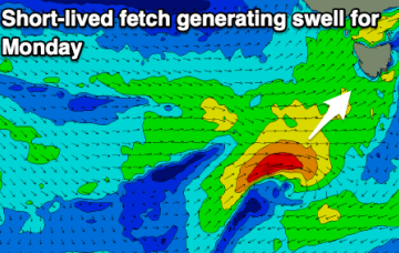
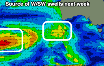
Inconsistent but fun sized W/SW swells with favourable winds for the beaches come Wednesday through Friday.
Inconsistent but fun sized W/SW swells with favourable winds for the beaches come Wednesday through Friday.
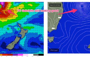
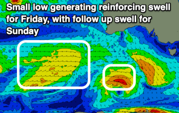
Now that the low axis of TC Gabrielle has moved south of the CQ coast we’ll see diminishing swells.
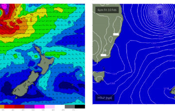
Severe tropical cyclone (Cat3) Gabrielle is currently tracking SE at about 21 knots and is located about 413 nm NE of Brisbane. This severe storm is expected to undergo an extra-tropical transition through Friday evening, resulting in an expansion of gale to severe-gales around its southern flank as it continues drifting south-east towards New Zealand.
We've had a good run but we look to be entering a slower period ahead of more action from next weekend.
Severe tropical cyclone (Cat3) Gabrielle is currently tracking SE at about 21 knots and is located about 413 nm NE of Brisbane. Early incarnations of the TC as it was drifting SW showed a fetch of storm force to severe gale NE winds around the NE quadrant which is producing a rare NNE-NE long period swell
Decent winds for the weekend with a fun sized swell for the South West. Larger surf is due next week but with dicey winds.
Severe tropical cyclone (Cat3) Gabrielle is currently tracking SE at about 16 knots and is located about 455 nm NE of Brisbane.
Weak windswells and average winds for the weekend, better into next week with a tiny, teasing swell on the Mid, better down South from Wednesday.
Distant W/SW swells with favourable winds developing from mid-next week following a trough and change tomorrow afternoon/Sunday.
We should start to see some long period N/NE swell appear, generated by the early stages of TC Gabrielle (developing tonight, actually).