Unusual long period N/NE energy; then an extended run of large E'ly swell

South-east Queensland and Northern NSW Surf Forecast by Ben Matson (issued Wednesday 8th Feb)
Forecast Summary (tl;dr)
- New S'ly swell for Northern NSW on Thurs, light winds in the south
- Small leftover E'ly swell elsewhere on Thurs, freshening SE winds north from Byron
- Strong, unusual N/NE groundswell building Fri (mainly SE Qld)
- Strong building E'ly swell through Friday; delayed across southern regions
- Large E'ly swells Sat thru' Tues; tricky winds at times
Recap
Peaky mix of south and east swells over the last few days, generally 2-3ft at most exposed beaches. Light morning winds, freshening afternoon sea breezes.
This week (Feb 9-10)
There’s another round of southerly groundswell moving up the Southern NSE coast today and it’ll provide a nice spread of surf across Northern NSW on Thursday.
South facing beaches will pick up the most size with sets around the 3ft mark, elsewhere we’ll see a smaller combo of east swell in the mix. SE Qld won’t pick up much of the south swell so it’ll be relying on the east swell, which is likely to ease a smidge from today but should otherwise still offer peaky sets at exposed beaches.
Local winds look OK across most of Northern NSW (light variable early, sea breezes later), though north from Byron and into SE Qld we’ll be at risk of fresh SE winds from the get-go as a ridge of high pressure strengthens in response to the southerly advances of TC Gabrielle in the Coral Sea.
This will affect surface conditions at exposed beaches so you may have to grovel around the semi-protected points for a small wave. Early morning may offer a window of light S’ly winds across the southern Goldy Coast.
Friday looks very interesting indeed.
Northern NSW will see easing S’ly swells from Thursday and there’ll be some minor E’ly swell in the water too, with similar winds as per Thursday.
However, we should start to see some long period N/NE swell appear, generated by the early stages of TC Gabrielle (developing tonight, actually). Model guidance has this particular slice of energy building through the day, reaching a peak later before easing into the weekend, and it’s a particularly unusual combination of period, size and direction for our neck of the woods.
In similarity to how south swells will bypass most of the SE Qld coast but show strong at south facing beaches in Northern NSW, this N/NE energy will probably appear the opposite - showing well at ‘north facing beaches’ (i.e. southern corners in SE Qld), and may bypass broad stretches of the Northern NSW Coast, depending on local bathymetry and land barrier shadows.
At the same time, we’ll also see a building mid-range E’ly swell from TC Gabrielle, which by Friday morning could very be a Category 3 system, positioned midway between Fraser Island and New Caledonia.
How big will the surf get?
Both swells should be worthy of 4-6ft sets by the afternoon, though the secondary N/NE swell will result in much larger waves at protected spots than we normally see, which may give the appearance of larger surf regionally (one or two swell magnets may pick up 6-8ft sets, though they’ll probably be very wind affected).
Expect a longer delay on the arrival (and subsequent upwards trend) from both swells, south of Ballina - of which the N/NE will be very flukey in this region thanks to the swell shadowing.
It’s worth nothing that the modelled strength of TC Gabrielle is capable of a LOT more size than I have estimated, but working against its surf potential is its steady south-east track towards the Northern Tasman Sea. Should it become stationary in the Southern Tasman Sea (with a supporting ridge to the south), we could easily double these height projections.
As it is, there’s only a few spots that’ll handle this size, along with the accompanying fresh S/SE breeze in the north. No prizes for guessing where either.
Winds should be much lighter as you head south from the Northern Rivers too; still onshore but more manageable with the smaller, delayed surf trend.
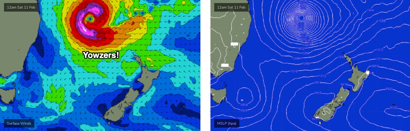
This weekend (Feb 11-12)
Over the next couple of days, TC Gabrielle will strengthen considerably and track south-east through the Coral Sea, enroute to the Northern Tasman. On Friday and Saturday we’ll see the cyclone muscle up against a large high near New Zealand, which will broaden and lengthen an impressive easterly fetch along its southern flank as TC Gabrielle undergoes extra-tropical transition.
It’s these developments - fair and square within our swell window - that will generate another four days of large easterly tending east-southeast.
We’ll see the most size across Northern NSW, with slightly smaller surf across SE Qld. Friday’s aforementioned secondary N/NE swell will ease steadily across SE Qld into Saturday so we will start to see a more typical spread of wave heights across the region.
As for size, let’s ballpark 6-8ft sets across Northern NSW both days of the weekend - perhaps a little undersized early Saturday - smaller around 4-6ft at exposed beaches in SE Qld, smaller again along the points.
Interestingly, thanks to TC Gabrielle tracking quickly into the Tasman Sea, the local pressure gradient will be weak over the weekend, resulting in light morning winds and afternoon sea breezes (with a northerly risk for Sunday).
We’ll firm things up on Friday.
Next week (Feb 13 onwards)
As mentioned above, the slow moving nature of (by this time) ex-TC Gabrielle will result in easterly swells holding at a similar size (as per the weekend) through Monday, and probably Tuesday, before easing Wednesday.
A poorly orientated coastal ridge will bring about a northerly wind risk through this period so let’s not get too excited about the surf potential just yet.
It's worth nothing that the strength of TC Gabrielle has the potential to generate much larger waves than what I've mentioned above, however the core fetch (see below) will be aimed into the Coral Sea, slightly off-axis for our swell window. If anything, Sunday afternoon and Monday morning could see a period of even bigger surf than I have indicated (i.e. 10ft+ sets in Northern NSW). Let's be cautious for now. Either way, it's very likely to be large and powerful for several days.
There’s nothing else on the long term radar behind this, so let’s see how the model guidance is shaping up on Friday.
See you then!
Comments
Just cos I can, here's one of my favourite Ween tunes.
Haha, Ween doing their Thin Lizzy thing.
So many great songs but this is up there with mine too Ben. Above ocean man, push th' little daisies, p!ss up a rope, your party and wavin' my slater in the wind
fire up the water ponies boys and girls. time to step off into a crowded line ups like true heros.
Capricorn cam showing some fun ones already
Potential interesting unicorn left hand points in that NNE swell
For sure mate. Been a while since Jelurgal Point worked :)
TC Gabrielle is looking a treat, bubbling away..
Winds look terrible for us, Nor/East swell with strong Nor/East winds is the prediction for the Lower Mid/Nth Coast, hopefully we'll get some offshores in the mornings before the onshores set in to rob us of any quality waves.
ASCAT looking good for the N/NE groundswell.
cant wait to see what this unique swell does.
Three little letters....GBR
We just come in from the Swains, no good for surfing out there, it's a mess.
agnes cam looks fun
I hope someone films some stuff around agnes tomoz. Even Bundy could pump
That would be cool to see (Bundy)
Just saw someone make a 2ft barrel, nice. Nice left off the point at Kellys. 1770 on the pump.
https://www.swellnet.com/surfcams/agnes-water
https://www.gpcl.com.au/environment/live-beach-cameras/
It’s very very ordinary this morning, 2ft at best at greenmount and packed
Largely overhyped swell unfortunately. Hundreds out at Noosa and lucky to be 3 ft, even at Granite.
As per the notes, the N/NE swell is expected to peak later today. By my calculations there's still twelve hours of sunlight remaining in SE Qld.
I wouldn't write it off just yet.
Very true, I've misread the note. Apologies all.
As Ive said many times in swellnet forecast notes before u paywalled them. NNE groundswell virtually dont exist in Qld. At best, they are a faint almost unnoticeable pulse. Perhaps its Bathymetry. But I spent most of my life surfing SEQ, and fishing the GBR.
ENE swells? Yes. Perhaps even a smidgen more than ene. true NE groundswells are a one in 20 year event, usually victory at sea with raging easterly winds, and a cyclone sitting off NE Fraser Island. NNE are a non event.
Im no exeprt in bathymetry. U had a dude write some articles here a while back on bathymaetry. Perhaps get him to look at it. Does the NW to SE slope of the great barrier reef do something? Doe that continental shelf redirect the deeper groundswells toward NZ? Lady Elliot Is and Fraser a factor?
In the future alwasy tread carefully calling "nne" swells in Qld. Cheers
you want to give advise to the forecasters/owners of swellnet but don't want to pay $6 per month for the privilege on having access to the forecast notes. ok sheepy
I do take Sheepies point- these are extremely rare and flukey swell events.
I also surfed a N facing Point this morning and there was some obvious extra energy from that direction in the water.
I got back slammed so hard on a shallow sandbar I saw star and am now hobbling.
a quick glance at the greeny cam shows the angle of swell.
Looks like the NNE swell is fading up north, Capricorn cam shows half the size of yesterday. Think it's (the NNE component that is) all over by tomorrow FR?
Currently sitting on beach along Kawana doing a lunch check. Pretty messy and no size. Definitely has some north in it but I wouldn’t classify it as “swell”.
For starters, Its advice, not advise. Secondly, I dont need their forecasts. I used to enjoy bantering over the forecasts. But I'm not paying a site to ad in my 40 years of surf and professional fishing/ ocean experience. Hence you rarely see me in here now.
But I totally get why Ben and Craig have chosen to do it. Their business model, their choice.
Still nice to see you stop by in the comments Sheepy- especially with a cyclone to get our teeth into.
Cheers, Steve. Only just getting back into the water. Had a bit of a nasty non surf accident. Out of action for nearly a year. Physio is a bitch. Stay safe
Fair enough sheepy. lets see how this afternoon plays out.
There was a perceptible difference out at a North Facing point/beachie just now, but it's main effect seemed to be peaking up the East swell. And inconsistent sets, predictably. The run-out tide will probably reveal it all a bit more. Water was fluorescent blue.
PL er....Overhyped Swell ....Go for a late arvo Surf out Granites....then Report back
PL has trouble reading. Calling a swell overhyped before it arrives is wild.
is that a ski on the cam at 2 foot noosa lmao
JW back in town. Quick, get Harry on the blower.
hahahahahahah.
Haven't they both left town now?
Who gets "local" status now?
Haha, a mate grew up there and goes out every decent swell, reckons he gets heaps of waves, just burns the floaters, so maybe him... and a thousand others...
FR Are you planning a Bribie Island strike mission?
negative.
surfed middle to southern beachie on the GC, was a bit of fun, angle of swell helped create some sidewinders.
Definitely a bit of push in the swell. Solid 3 foot (overhead).
2 kook foil boarders weaving their way through a crowded greenmount line up right now on the cams.
WTF is wrong with these people? Only a matter of time before someone gets hit a dies from one of these things.
100%. Can they not fuck off to Bilinga??
Kirra would actually be a better wave right now and not 1 person out.
I know who you are talking about. Those fuckwits are out there every day. One of them had a a huge cry at me at the spit one day 'for taking all the waves'. I politely told him to fuck off.
Peak swell periods just jumped to 14 seconds at the North Straddie offshore boy... still suggests a Friday arvo peak in SE Qld (not surprised Capricorn trend is heading down, it's much further north).
Oh, and the buoy is reporting swell direction as N/NE.
Thats just 1 out off 11 buoys, indicating an anomaly at this stage. The NNE swell is an over hype https://www.qld.gov.au/environment/coasts-waterways/beach/monitoring/wav...
It's not an anomaly. It's an offshore buoy reporting regional swell direction associated with the long period energy, which is N/NE as expected.
Inshore buoys will always record a swell direction that's been attenuated by local bathy and period (i.e. more E/NE).
In similarity, the offshore Tweed buoy will often record S/SE (or even S) when the inshore buoys are reporting SE or E/SE.
You can clearly see the extra N in the swell angle on Cooly cams.
There's the swell!
Definitely showing more at N facing Points than open beaches.
Possibly hidden in the sea state there?
I can confirm a very rapid change in surf conditions between dawn this morning and mid afternoon. And yes it had NE in the swell direction sheepy as I was at a north facing beach all day.
bigger sets rolling in now.
Wow..
Tracking quickly SE though..
Here in lies the key. Looks great on a still shot. But it’s rapid SE track is a bitch for swell production.
Yeah, it's picked up speed since last JTWC update.
Should slow overnight.
Here it comes, lines to the horizon, greenmount has doubled in surfers the last hour, this afternoon is going to be crazy crowded
looking at the crowd at greeny now, it's like 3-4 people thick... along the whole length. I also note that the angle is making it almost to fast allowing around 50 people to ride each wave, with 2-3 taking of at once with a take off/drop in, pump and pull in or whack a closeout. to be repeated every 20-30 meters.. as the wave rifles down the point..
Downgrade.
Any chance the wobbly noosa cam will be stabilised one day? getting motion sickness
I did drive by of Alley just after 1.00. Kites only, would blow dog off a chain.