Poor weekend, better options next week

South Australian Surf Forecast by Craig Brokensha (issued Friday February 10th)
Best Days: Protected spots South Coast today, Mid Coast for the desperate later Monday but more so Tuesday morning, South Coast Wednesday morning, Thursday morning and early Friday, Mid Coast for the keen Thursday morning
Features of the Forecast (tl;dr)
- Strengthening W/NW tending W/SW winds Sat with a building windswell on the Mid
- Easing windswell Sun with strong S/SW-S winds (S/SE early on the Mid)
- Small, inconsistent mid-period W/SW swell building Mon, peaking Tue with mod-fresh SE tending S/SE winds Mon, gusty E/SE-SE tending S/SE Tue down South (S/SW in the PM on the Mid)
- Reinforcing, inconsistent W/SW groundswell Wed PM and Thu AM, with morning N/NE winds ahead of SE sea breezes mid-PM both days
- Easing surf Fri with strong N/NW tending SW winds
Recap
Favourable conditions again yesterday morning down South with variable winds and 2-3ft of S/SW swell, still fun into the afternoon with relatively weak sea breezes. This morning at dawn conditions were great across all spots with 2ft of swell but freshening W/NW wind kicked up quickly, limiting the best waves to protected spots. Middleton Bay and Point look the best for a surf on something with a bit of volume.

Double barrel at Middleton.. Must be tripp'n
This weekend and next week (Feb 11 - 17)
The weekend isn't looking too crash hot, with today's freshening wind linked to a weak low moving in from the west. A tiny windswell will be whipped up across the Mid Coast today, while stronger WNW-W/SW winds tomorrow will produce more size to 2ft but with poor conditions.
The South Coast will be clean in protected spots but tiny with today's swell easing from 1-1.5ft. It'll be ideal for a log before winds go SW after lunch.
Sunday unfortunately looks poor for both coasts with winds shifting gusty S/SW-S through the day, S/SW on the Mid (likely S/SE early), but with no decent size left from tomorrow. Easing 1-1.5ft sets are likely in the gulf.
A high will move in slowly through early next week, shifting winds SE Monday morning, stronger S/SE into the afternoon, with gusty SE-E/SE winds Tuesday morning, giving into S/SW sea breezes on the Mid and S/SE sea breezes down South.
Swell wise, some inconsistent mid-period W/SW energy is on track to build Monday afternoon, peaking Tuesday.
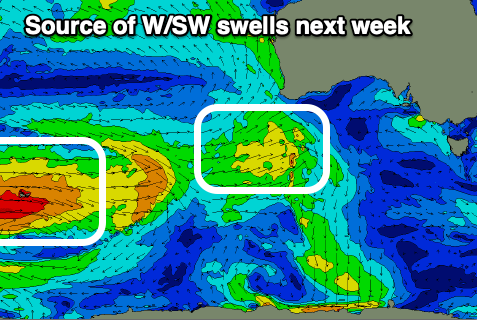
The source was a relatively weak, easing polar low spawning from the Heard Island region, with it generating weaker W/SW winds while dissolving south of WA today.
Today's fetch should generate Monday's building size, with increasing sets to 1-1.5ft, while less consistent levels of swell to 1-1.5ft should continue Tuesday, with the possibility of the odd 2ft'er on the favourable parts of the tide.
Middleton won't see much size from this and looks to come in around 2ft+.
The swell is due to ease back temporarily across the Mid Coast Wednesday morning, while the South Coast should still see 2ft waves across Middleton as winds tend light offshore out of the N/NE.
Later in the day but more so Thursday morning, a slightly stronger but inconsistent W/SW groundswell is due to arrive.
This is being generated by a secondary, stronger polar low that fired up west of the Heard Island region yesterday, generating a great fetch of severe-gale W/SW winds.
The low will weaken over the coming days while projecting east, with inconsistent sets to 2-3ft due across Middleton Thursday morning and 1-1.5ft sets across the Mid Coast.
Winds look to favour the South Coast most of the day with a N/NE offshore, giving into mid-afternoon sea breezes, clean again Friday morning with stronger N/NW winds ahead of a change.
This change will be linked to some stronger frontal activity projecting up towards WA later week, bringing decent swells from next weekend. More on this Monday, have a great weekend!