Fascinating synoptics for the next coupla weeks

Sydney, Hunter and Illawarra Surf Forecast by Ben Matson (issued Monday 18th May)
Best Days: Inconsistent mix of E/NE swell Tues/Wed and Thurs. Large S'ly swells developing Fri, persisting through the weekend and probably early next week. Decent E/NE swell over the weekend too, easing next week.
Recap: E/NE swells persisted all weekend though slowly eased in size. Saturday managed 3-5ft sets, Sunday saw occasional 3-4ft waves and today dropped to a very inconsistent 2-3ft. Winds have been generally light and variable so conditions have been clean. There’ve been a few patches of onshore winds but overall it’s been pretty good on the surface.
This week (May 19 - 22)
The short term forecast period is all about lully, inconsistent, long range E/NE swells - not too dissimilar to what we saw over the weekend though generated further away, from a flukier source, and therefore with lower confidence and a smaller number of locations likely to pick up the bulk size.
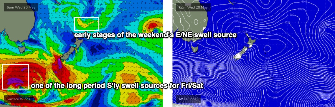
There’s no change to the broader thinking discussed last week, which is for small surf on Tuesday to be somewhat ‘between pulses’, ahead of a longer period (12-13 second) pulse pushing through for Wednesday and Thursday, before smaller energy pads out Friday and Saturday. The source of this fetch - a broad trough to the NE of New Zealand - has only just started to rotate out of our swell window so we should see some form of E’ly energy through until the weekend.
As for size, and keeping in mind that there will be extremely long breaks between the sets (so, no need to preface each day with ‘inconsistent’) I’m expecting Tuesday to see 2ft sets, before rebuilding to 3ft+ on Wednesday and Thursday, then easing to 2ft Friday.
Of course, the sheer inconsistency of this swell means you shouldn’t view any session this week as as a regular surf day. There might only be a couple of sets properly breaking every half an hour, so keep your expectations low and be pleasantly surprised if it exceeds them.
Actually, the inconsistent may be slightly overstated for Wednesday and Thursday anyway. A building ridge in the Tasman Sea is poorly aligned for our region but should allow a small spread of E’ly swell to reach Southern NSW, probably no more than 2ft+ but enough to keep open beaches rideable between the very infrequent long period sets from the South Pacific.
Surface conditions look OK each morning, but a high in the Tasman Sea will freshen NE winds Tuesday afternoon, before swinging more N’ly then N/NW on Wednesday. A general W/NW offshore flow is then expected on Thursday. Either way, the early sessions will have the best conditions, and both Tuesday and Wednesday will be at risk of some form of northerly flow. Wednesday and early Thursday may also see some small N’ly windswell in the water though no major size or quality is expected.
Friday is a real curveball.
At some stage the wave buoys are expected to pick up the leading edge of several long period pulses, originating from a succession of broad polar lows traversing the waters well SW of Tasmania over the coming days (see below). Swell periods will reach 18 seconds from this source, and in its own right should produce 4-5ft sets at south facing beaches and 6ft, maybe 6-8ft bombs across south swell magnets like the Hunter very late Friday afternoon and through Saturday.
But, coincidentally, a Tasman Low is expected to deepen off the NSW coast overnight Thursday, displaying gale force S’ly winds off the South Coast that will probably reach storm force through Friday.
Locally, winds will be generally SW across most parts of the coast but Sydney through the Hunter should see a reasonable period of W/SW winds - at strength - and this Tasman Low should generate building surf from 4-5ft (south facing beaches) to 6-8ft by late afternoon.
Of course, locations not exposed the south will be much smaller and the blustery conditions won’t be enticing for everyone, but there will certainly be plenty of size to finish the working week.
Let’s fine tune the size and timing on this in Wednesday’s notes.
This weekend (May 23 - 24)
There’s a bit of divergence between models as to how the synoptics will play out this weekend. Specifically, the US solution has - in addition to the Tasman Low - an ECL developing off SE Qld that the European solution doesn’t.
As such we need to be cautious on assessing the model output (I’m not confident on the ECL), but for now it’s a reasonable good chance that the Tasman Low will dominate our neck of the woods both days, with large southerly swells and gusty winds. There is a risk that the Tasman Low may retrograde a little too far west on Saturday, shutting down the southerly swell source somewhat, but I’ll have a better understanding on that over the next few days.
In any case, the proximity of the low to the mainland should allow for the wind to be more SW in direction at the coastal margin (even W’ly at times north from Sydney to the Hunter), and surf size should hold both days somewhere in the 6ft+ range. Also, remember that Saturday will see not only short range energy from the Tasman Low but also long period swells from the polar low (generated many days prior).
A developing surface trough north of New Zealand later this week (in almost the same location as the source for last Fri/Sat’s E/NE swell) is expected to develop another round of similar swell, with early indications suggesting 3-4ft+ sets from this direction both days.
Also in the mix this weekend will be another, smaller E/NE swell, originating from the northerly infeed into the eastern flank of the broader Tasman Low. There won’t be much size associated with this fetch but it’s worth noting anyway.
Next week (May 25 onwards)
At this stage I’m expecting the Tasman Low to meander thorough Southern NSW’s south swell window well into the start of next week, which suggests elevated southerly thru’ south-easterly swells through Tuesday and maybe even Wednesday.
Our weekend E/NE swell sources (two of ‘em, an E’ly fetch north of New Zealand and a N’ly fetch through the eastern Tasman Sea) will continue to supply energy across Southern NSW early next week. It’s too early to pin down specifics though.
So, there’s plenty to look forward to next week!
See you Wednesday.
Comments
Phew! It's not just me.
I'm hoping for the first one to move some fucking sand off the beach and create some banks! Nothing but cloesouts.
Wow, Is there a factor that is making this low unpredictable?
May I ask, do you have a "gut" feeling on the behaviour of this system? ( a science question, not an impatient forecast question).
Or, is one of the models just completely wrong?
Cheers
Each computer model has its own strengths and weaknesses, so it's not uncommon for the models to be divergent. It's more obvious right now because this weather system is forming right on our doorstep.
I see. Thanks.
We need a massive ECL .. to create some banks again it’s shithouse at the moment( gutters rip bowls etc) .. one decent bank for to many surfers
FWIW, 'massive ECLs' are not guaranteed to create good banks. They can often do the opposite.
yea I've noticed they often just create a massive shoreline parallel gutter with a close-out way out the back.
I’ve seen some classic sand banks form after an ecl on the central coast. Not guaranteed all the time but somewhere will benefit
I've found most spots round my haunt benefit from a big dump of rain moreso than the swell. fingers crossed we get some.