Dynamic action on the charts

Sydney, Hunter and Illawarra Surf Forecast by Ben Matson (issued Monday 27th April)
Best Days: Thurs: peaky NE swell with a W'ly change at some point (lunch/arvo looking great). Fri: fresh offshore winds, arvo building S'ly swell. Sat/Sun: large series of S'ly swells, easing from Mon.
Recap: Small flukey south swells graced the NSW coast over the weekend. Size didn’t manage to crack much more than 1-2ft across most south facing beaches, other than the Hunter which saw a few larger sets, however a small NE windswell graced exposed beaches on Sunday with sets generally around the 1-2ft mark. Winds were generally light both mornings with sea breezes Saturday afternoon and moderate NW winds Sunday afternoon. Today started off small but has built from the south, with early 2ft sets reaching 3-4ft this afternoon. A moderate southerly flow affected some regions early morning but it’s become generally light and variable this afternoon.
This week (Apr 28 - May 1)
Tuesday is expected to be on the backside of today’s pulse of S’ly swell. Early morning may see some leftover 2-3ft sets at south facing beaches (bigger near 3-4ft across the Hunter) but by mid-late morning it’ll be down to 1-2ft and 2-3ft respectively. Expect smaller surf from this source at locations not open to the south.
Also in the mix on Tuesday may be some small building E’ly swell from a developing ridge across the central Tasman Sea, and also some minor NE windswell from a local fetch adjacent the coast. No major size is likely from either source though.
As for conditions, we’ll see a brief period of light morning winds ahead of a freshening afternoon NE breeze.
The broad scale pattern for the rest of the forecast period will be characterised by an amplifying upper level long wave trough across the eastern states.
Essentially, we’ll see freshening N’ly winds through Wednesday and early Thursday - generating a local NE swell - before the LWT pushes eastwards, and a series of S’ly swells impact the region from Friday onwards.
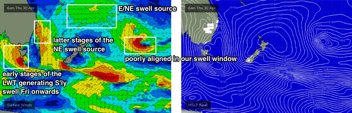
As a side note: it’ll be hard to detect beneath the stronger local swells, but a developing high in the Tasman Sea (partly responsible for the local mid-week NE windswell) will also display a broad E’ly fetch through the South Pacific (see chart below) and this will generate an otherwise useful E/NE swell for our region later this week and through the weekend. Under any other circumstances it would have delivered fun waves, but it’ll largely go to waste this time ‘round.
So, back to the influence of the LWT.
Wednesday will largely be pretty average in the surf department, with northerly quadrant winds and building short-range NE swells from 2ft+ to 3ft+ during the day (thanks to a longer upstream fetch, the South Coast will see bigger waves for this source). There'll also be some small peaky E'ely swell in the mix too, leftover from Tuesday.
The synoptics suggest pockets of light winds north from Sydney but this will be the exception rather than the rule.
Thursday is a much better option. We’ll see the NE swell reach a peak through the morning with occasional 3-4ft+ sets (smnaller at south facing beaches, and across the northern Hunter), but winds will swing from the north to the west as a cold front crosses the region. The timing on this change could be as early as mid-morning, but the best waves will probably happen around the middle of the day once it's hard some time to iron out the lumps and bumps from Wednesday night's winds. Local wind strengths could become quite gusty (from the west) into the afternoon and an easing swell trend is likely after lunch too.
Friday will be a really complex day for surf.
We’ll still be under the influence of strong westerly winds, and they’ll be gale to storm force exiting eastern Bass Strait. There’s not enough south in this westerly airstream to be totally confident for a flukey south swell, but the strength and breadth of the fetch can’t be ignored and it’s likely we’ll see an upwards trend through the day (leftover NE swell will be very small early morning, and flat by the afternoon).
At this stage I’m expecting most beaches to miss out completely, and I’m really not anticipating much new action before lunch - but south facing beaches should pick up occasional 2-3ft+ sets as the afternoon wear on (peaking late in the day) with the Hunter seeing occasional 3-4ft+ bombs on dark.
However, this is a very flukey swell source so let’s check back in on Wednesday to see how the models are resolving the pattern.
This weekend (May 2 - 3)
The LWT will push further east on Friday, allowing a series of surface fronts to properly enter our south swell window from that time onwards, generating large southerly swells for the weekend.
The general outlook is for fresh and gusty winds both days, initially W’ly tending W/SW on Saturday and then W/SW tending SW and then S’ly on Sunday.
It’s too early to pin down size specifics, but wave heights should reach 6ft or more at south facing beaches on Saturday, and possibly 6-8ft Sunday (with bigger waves are likely across the Hunter). Elsewhere it’ll be a lot smaller, thanks to the strong southerly swell component in the direction. But there won’t be any shortage of size this weekend.
I’ll fine tune things on Wednesday.
Of and of course, there’ll be a small underlying E/NE swell too.
Next week (May 4 onwards)
Solid but gradually easing southerly swells looks to be on the menu for the first half of next week.
There’s nothing else of any interest standing out on the long range charts right now (as per the chart below, a poorly aligned sub-tropical local east of New Zealand won't do anything for us.. thought is looks nice on the synoptics!).
See you Wednesday.
Comments
Worth pointing out that these notes have a heavy GFS bias. However, EC and other models are delaying the broader LWT progression, which would result in the timeline for the upcoming south swell shunted back a day or so.
Still early days though.
Can we order it for Monday when everyone goes back to work?
G'day, this is probably a stupid question, but what are the models? I've heard U.S. and European mentioned. Is there just one for these major continents? Thanks
My weather nerdism is only relatively mild but basically there are 3 or 4 widely known global weather models. Guessing they run all sorts of algorithms based on a range of inputs to produce forecast charts. The forecasts go out to 16 days but probabilities diminish the further you go out (imo).
As per Belly's reply.. the weather services of many countries run their own atmospheric models, which predict the state of the atmosphere up to a week or two (sometimes more) in advance, with varying degrees of accuracy depending on what you're looking for.
There's a few models from the US, a few in the EU, a UK model, Canadian, Japan and also an Australian model, all at different resolutions and domains, and of different levels of availability. Each has its own strengths and weaknesses.
Thanks. Do you have to pay to use their models? Like a subscription?
How’s the Swellnet model system coming along? And am I right in remembering that Craig discovered the full effects of the LWT on surf?
Our own model is getting an upgrade in the few months actually, a few recalculations but on the whole we're pretty happy with the way it performs.
Otherwise, we've had a bunch of ongoing R&D for quite a while, one of which involves the LWT. Hardest part is getting the data into a meaningful, user-friendly format. But there are some interesting learnings.
Yes for some, no for others. But then you've gotta be able to do something with the data (create charts/graphs, run wave models, etc). And you've gotta have significant servers to do all of that work (which costs a lot of $).
How do I my photos in the mix for photo of the day on the website Ben?
You can shoot them through to me, mate:
stuart@swellnet.com
1500x1000 unwatermarked jpegs preferred.
G'day Ben, will be interesting to see how the next South Swell event pans out on the Coal and Illawarra Coasts as we are not known to pick them up as well as Sydney and the Hunter.
Keen on this NE swell if the southerly is delayed
Is this because the swell is "lost" in the primary swells?
"As a side note: it’ll be hard to detect beneath the stronger local swells, but a developing high in the Tasman Sea (partly responsible for the local mid-week NE windswell) will also display a broad E’ly fetch through the South Pacific (see chart below) and this will generate an otherwise useful E/NE swell for our region later this week and through the weekend. Under any other circumstances it would have delivered fun waves, but it’ll largely go to waste this time ‘round."
It's because if there's a large south swell in the water, it's hard to see a small underlying E/NE swell. Not referring to model guidance.
Does this mean that beaches not open to south swell but are northeast magnets could get some waves through the weekend too ben?
Yes.
sounds good too me
Does anyone know when or if we are allowed to go say 2 hours down the coast for a surf? A mate told me we can from this Friday, just want to confirm. Thanks