Coupla south swells to keep the coast active

Sydney, Hunter and Illawarra Surf Forecast by Ben Matson (issued Monday 23rd March)
Best Days: Tuesday: solid S'ly swell (peaking in the a'noon), generally light morning winds then light/mod NE sea breezes. Size easing Wednesday with early clean conditions. Friday: easing S'ly and SE swells with light morning winds.
Recap: The weekend’s S’ly swell arrived a little later than expected, building from mid-morning Saturday (across Sydney), reaching a late peak around 4ft at south facing beaches with 5-6ft sets across the Hunter. Size eased from 3ft+ on Sunday, and both days saw early light winds and afternoon sea breezes (and a late S’ly change Sunday). Today saw a new S’ly swell rebuild back up to 4ft at south facing beaches (4-5ft across the Hunter) and mainly S’ly winds have created issues on the surface.
This week (Mar 24 - 27)
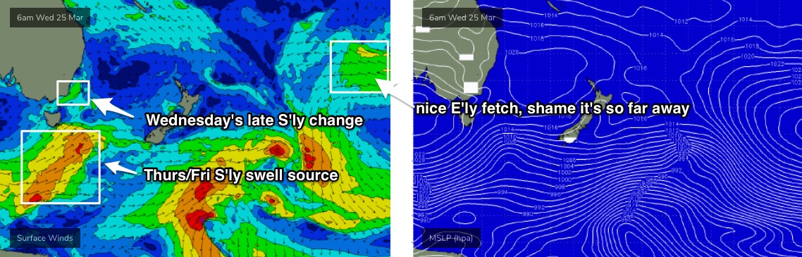
The front responsible for today’s change will clear to the east overnight, and we’re looking at lighter winds and sea breezes for the next two days ahead of the next southerly change, due late Wednesday, persisting through Thursday.
Although today’s S’ly swell will ease slowly overnight, a new long period south swell will push through during the morning, generated by a strong polar front/low that tracked well south of Tasmania over the weekend.
Wind speeds were a touch below model forecasts but the fetch was very broad in coverage, so at this stage I don’t have any major reason to downgrade the outlook of the last week or so.
And that is for south facing beaches to rebuild back up to 3-5ft tomorrow (more likely after lunch than before, except south from Sydney, so anticipate smaller surf at dawn), with some reliable south swell magnets such as the Hunter picking up 5-6ft+ sets late in the day.
As per usual, expect much smaller surf at beaches not exposed to the south, and the bigger sets will be quite inconsistent, coming from a more distant source (though there’ll be consistent smaller waves in the mix from today’s energy).
Early light winds will precede an afternoon NE sea breezes and Wednesday will see a steady easing trend from 3ft+ at south facing beaches (bigger in the Hunter), down to 2-3ft by the afternoon (smaller elsewhere as usual). Light morning winds may shift NW for a period but a S’ly change is due into Sydney mid-late afternoon.
We’ll then see two main swells pad out the rest of the week. A small trough will develop off the Southern NSW coast on Thursday, and a developing S/SE tending SE fetch in conjunction with this will build short range swells from this direction, peaking early Friday with 2-3ft sets.
More dominating from a surf perspective will be a bigger S’ly swell from the parent low/front associated with Wednesday’s change, which should kick up 3ft, maybe 3-4ft surf across south facing beaches on Thursday (4-5ft+ across the Hunter, but smaller elsewhere), easing from 3ft on Friday. Anywhere not open to the south will be smaller but there should be enough options to find some fun waves.
As a side note, the early incarnation of the primary low associated with this front (for Thursday's S'ly swell) is currently well below WA, and it's really strong - but positioned right on the northern periphery of our acute south swell window. Wind speeds have been really strong around the low but I fear most of the generated energy will bypass our coast (that being said, if we see longer-than-expected swell periods and a couple of bigger clean up sets in the 6ft+ range at south swell magnets, this is where it will have originated from).
Unfortunately, Thursday’s winds look problematic under a fresh - though easing - S’ly flow (slim chance for pockets of morning SW winds… not confident on this at all). Friday is a better bet with light variable winds and sea breezes.
This weekend (Mar 28 - 29)
The weekend looks a little average.
Saturday’s conditions will be clean with light variable winds and sea breezes, before freshening N’ly winds ruin things on Sunday.
Surf size will bottom out on Saturday as the S’ly and SE sources ease from 2ft at south facing beaches (a smidge bigger through the Hunter). As NE winds freshen on Sunday, a small undercurrent of E/NE swell will build across the region thanks to a broadening trade flow across the Northern Tasman Sea on Friday and Saturday.
No major size is likely from this source - and conditions look a little suss - but there’ll be waves both days. Probably Saturday morning for the pick at this stage.
Next week (Mar 30 onwards)
Small E/NE trade swells are expected early next week, with a suggestion for an enhanced E’ly flow to develop north of New Zealand next weekend, providing a mid-late week kick in larger surf for our region. Let’s check back on Wednesday to see how that is tracking.
There's also a nice though extremely distant source of E'ly swell developing in the Far South Pacific over the next few days (see below) that'll provide some small long range E/NE swell during the middle of next week. Ordinarily it woudn't be worth reporting unless all of our other swell windows become inactive, but I'll keep a watch on it anyway.
Otherwise, a surface trough/low in the south-western Tasman Sea on Monday looks like being a potentially punchy source of swell for our region mid-next week, and strong Southern Ocean fronts behind this may generate some useful S’ly swell over the following days. But it’s too early to have any confidence in how this will play out.
See you Wednesday!
Comments
Hey Ben, I know your good at forecasting, but this weekend and next week - End of May is bit of a stretch. Squidy
Shit! Didn't meant to leak our new R&D output. Have put it back under wraps.
Are they still monitoring surfers and keeping surfers out of the water on the EB?