Lots of southerly swell on tap

Sydney, Hunter and Illawarra Surf Forecast by Ben Matson (issued Monday 11th November)
Best Days: Tues: peaky NE swell. Wed/Thurs/Fri: strong S'ly swell with good winds.
Recap: Saturday delivered building S’ly swells, which reached 3ft+ across Sydney’s south facing beaches, larger near 4ft+ across the Hunter coast. Size eased into Sunday morning ahead of a late kick of new S'ly swell that came in a little under budget, peaking around 3-4ft at south facing beaches. Both Saturday and Sunday morning were clean with light offshore winds, ahead of moderate SE breezes into the afternoon. Size has eased back from early 3-4ft sets, now down to about 3ft. Early light offshore winds are now freshening from the NE.
This week (Nov 12 - 15)
This afternoon’s NE winds are expected to veer N’ly overnight, and their alignment within our immediate swell window doesn’t look overly promising for any major size. Still, we’ll see building NE windswells into Tuesday with perhaps some 2-3ft sets at reliable NE facing beaches early morning, easing to 1-2ft by lunchtime and into the afternoon.
Please keep updated on the local bushfire situation too, as it's shaping up to be very dangerous across large swathes off the Southern NSW coast.
Surf conditions will improve as winds trend more N/NW then W/NW ahead of a vigorous S’ly change that’ll push up the South Coast into the afternoon, reaching Wollongong around 5pm and then Sydney within an hour or so of sunset. It’ll probably arrive a little too late to generate any notable swell increase for Sydney, Hunter and Illawarra coasts.
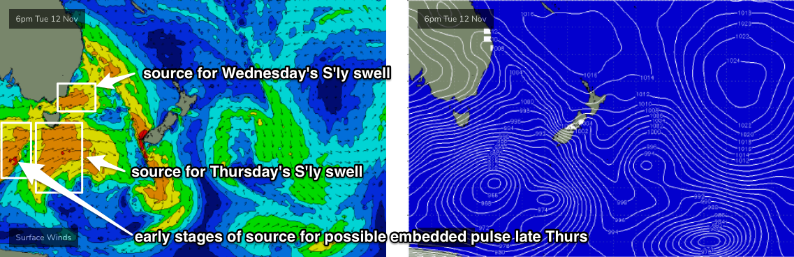
Tuesday’s southerly change will be at the the head of an amplifying long wave trough, that will dominate our surf outlook for quite a few days, slingshoting a series of strong fronts through the lower Tasman Sea from late Tuesday through Sunday or Monday.
At this stage, the front end of the storm sequence will be the most active and also the best aligned within our swell window, relative to Southern NSW’s swell prospects. Trailing fronts later this week will steer more zonally (west-east) and will consequently result in smaller surf throughout the region into the weekend.
Whilst Tuesday’s change will maintain W/SW gales across the Far South Coast into Wednesday, the front will largely clear to the east north from about Ulladulla, and a weak ridge of high pressure will allow light offshore winds to provide clean conditions on Wednesday morning. South facing beaches should push up into the 3-4ft+ range, and exposed south swell magnets like the Hunter should push 4-6ft at times, though anywhere not open to the south will be much smaller. Light to moderate sea breezes are expected after lunch.
Surf size will probably ease a touch into Thursday should still remain active thanks to the gale force fetch exiting eastern Bass Strait. But, we’ll see a strong secondary S’ly groundswell fill in on top, from the parent low traversing the waters south of Tasmania on Tuesday.
Additionally, a strong secondary front swapping around the primary low just south of Tasmania (late Tues, into Wed) should provide a short lived pulse of slightly larger surf either late Thursday or perhaps early Friday.
As such, I’m expecting overlapping S’ly swells to maintain 3-4ft across south facing beaches for Thursday, with a possible late kick into the 4-6ft range (again, bigger across south swell magnets). The South Coast is your best chance of picking up this embedded S'ly pulse before the sun goes down.
Wave heights will ease steadily through Friday but early 3-5ft sets at south facing beaches can’t be ruled out at dawn (again, bigger across the Hunter). But expect much smaller surf throughout the day as we push onto the backside of this event.
It’s worth pointing out that the swell sources are pretty flukey - the fetch will be SW, and coming ‘round the Tasmanian corner - so there’ll be a wide variation in size across Southern NSW, but on the balance there’ll be stacks of south swell all week to pick and choose from.
As for conditions, Thursday and Friday are both looking very good with light variable winds and afternoon sea breezes.
Let’s fine tune the details in Wednesday’s update.
This weekend (Nov 16 - 17)
A weak southerly change is on the cards for early Saturday morning. It’ll be shallow and short lived so won’t be too detrimental but needs to be closely monitored.
As for surf, Friday’s steadily easing S'ly swell will be down to about 2ft+ at south swell magnets for Saturday. Poorly aligned frontal activity below Tasmania Thursday and Friday will generate a small spread of similarly sized swell but it’ll only favour a handful of spots.
The storm track will lineup marginally better on Saturday which means late Sunday has a slightly bigger pulse of southerly swell on the cards, but not by much. Again, only south swell magnets are likely to benefit.
There’s also a suggestion for a trough to develop which may lead to freshening onshore winds during Sunday. I’ll have more info on this in Wednesday’s update.
Next week (Nov 18 onwards)
Another reasonable front is expected to pass below Tasmania on Sunday, which suggests a modest bump in southerly swell early next week.
Otherwise, the long term trend hints at coastal troughiness which could be the precursor to a significant local generating system in the western Tasman Sea some time next week.
Comments
Moody as southerly change!
It felt like ice when it hit huh!?!? I had to go down the harbour and wait for it, I really needed to be there to witness it's arrival.
Not quite ice haha, but def a sudden drop with the wind. Was great!