Small easing E'ly swells ahoy

Sydney, Hunter and Illawarra Surf Forecast by Ben Matson (issued Wednesday 19th March)
Best Days: Great condtions for the foreseeable future but only small surf on offer. Mid-late next week should see a return to slightly bigger swells with an E'ly swell and a S'ly swell due around Wednesday and Thursday.
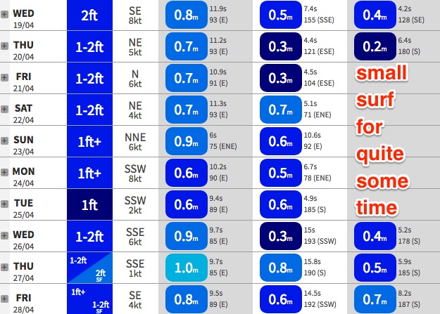
Recap: Our extended run of E’ly well is still continuing to produce fun waves across Sydney beaches, easing from 3ft+ Tuesday to 2-3ft today. Winds have been light so conditions are clean.
This week (Apr 20 - 21)
Our extended run of E’ly well will continue to slowly ease throughout the rest of the week.
Most swell events are usually up and down over the space of a day or two, but this particular one is unusual - it arrived on Saturday and has provided fun waves for the last five days, and in total should extend out to almost seven or eight days of rideable energy (interestingly, the early stages of the weather system that generated this swell was first mentioned in these Forecaster Notes as far back as Monday, 3 April - sixteen days ago). It's rare to see lengthy runs of easterly swell from distant South Pacific systems, and even more rare for these swells to coincide with a long spell of favourable conditions.
Remember though - we’re on the backside of a long range groundswell, so set waves will be very, very inconsistent at times. And with no other swells in the water there’ll be no other energy to fill in the gaps. Expect max size up around the 2ft+ mark through Thursday and a little smaller into Friday, with long periods of tiny surf between waves.
It’s also probably worth noting (on the off-chance we see a stray wave at south swell magnets) a long range S’ly groundswell may glance the region over the coming days. This is the same swell that’s lighting up Bells Beach for the Rip Curl Pro today with 6ft+ bombs. However it formed in a very unfavourable part of the Southern Ocean for NSW so I doubt we’ll see much action across our coast. Leading edge swell periods will be around 19-20 seconds so we can’t completely rule out a few rare waves but in general I don’t think we’ll see much.
As for local winds - a slow moving, stable synoptic pattern will provide light variable winds for much of the forecast period. So, conditions will remain very favourable for the next few days.
This weekend (Apr 22 - 23)
Still not a lot expected this weekend. The long range E’ly swell will continue to ease (very inconsistent 1-2ft sets likely both days), and a small trade swell expected to build across Northern NSW and SE Qld this weekend won’t be favourably aligned for Southern NSW. A handful of beaches north from Sydney may pick up occasional 1-2ft waves from this source but it’s not worth working around.
Winds should generally be favourable both days but there’s more chance for a little more strength in the afternoon NE breeze.
Next week (Apr 24 onwards)
A deepening surface trough south of Fiji on Friday is expected to form a nice easterly dip over the weekend. At the moment it’s expected to slowly consolidate into a decent swell producing system by Sunday or Monday, however by this time it’ll start to push close to the swell shadow of New Zealand’s North Island. So this is a concern, which will require close scrutiny in Friday's notes.
Anyway, current expectations are for a new E/NE swell to arrive in a couple of stages - a small renewal of energy later Tuesday ahead of a more robust push in size through Wednesday and Thursday, where set waves could push up into the 3ft range.
Otherwise, the Southern Ocean storm track looks generally unfavourable for much of the period, with just a slight tilt towards the Tasman Sea early next week, which should supply some small long range S’ly energy building from later Wednesday into Thursday too. No major size is currently expected though, maybe some 3ft sets at south swell magnets.