Stacks of south swell on the way for Southern NSW, best Friday morning

Sydney, Hunter and Illawarra Surf Forecast by Ben Matson (issued Monday 10th October)
Best Days: Wed: early light winds and a mix of small to mod south swells. Thurs: large building S'ly swell but with tricky winds, best at sheltered spots. Fri: early light winds and a large, easing S/SE swell. Sat: easing S/SE swell and light winds early.
Recap: Saturday morning offered a brief window of clean conditions from Sydney to Newcastle ahead of a southerly change that decimated conditions throughout the day. Things cleaned up nicely early Sunday with mainly light variable winds (excluding a lingering sou'easter in the Hunter) and a new S’ly groundswell arrived much earlier than anticipated, punching a little higher than forecast too with occasional 3ft+ sets at south facing beaches. Freshening northerlies into the afternoon created bumpy conditions at open beaches and they’ve generated a low quality NE windswell for today, which reached a peak mid-late morning with sets around 2-3ft at north facing beaches. Conditions were bumpy early under a moderate N’ly breeze but they’ve cleaned up this afternoon with winds swinging NW - but this has come at a price, with the NE swell now easing across the region to 1-2ft.

Manly offered a few OK peaky waves early afternoon once the wind slackened
This week (Oct 11th - Oct 14th)
We’ve got a steady succession of south swells for the entire forecast period.
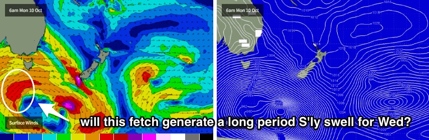
A slow moving gyre-scale (I liked Friday's adjective so much I’ve used it again!) low pressure system is moving through the Southern Ocean and will develop multiple S/SW fetches over the coming week.
Initially, they won’t be very well aligned within our swell window. So Tuesday will see a small increase in new south swell but no major size is expected. We’ll be starting from a very low base - mainly tiny leftover NE windswell from today - but south facing beaches should see a late increase towards 2ft, maybe some 2-3ft sets at reliable swell magnets right on dark (and a shade bigger through the Hunter).
This particular southerly swell will then hold into Wednesday morning before easing a little during the day, due to the short range fetch (between Tasmania and Sydney) weakening on Tuesday. So, in theory we should see an easing trend throughout the day, which is what the swell graphs are indicating.
However, an even less favourably aligned SW fetch - but much stronger, and broader, positioned SW of Tasmania today - will have generated a long period S’ly swell that’s due to move through the region on Wednesday, with peak swell periods in the 16-17 second range. Confidence is very low as to whether this swell will actually make landfall (as it will have been generated behind the Tasmanian swell shadow) so I’m unwilling to go out on a limb for this one. That being said, it’s entirely possible that reliable south swell magnets may pick up some very inconsistent 2-3ft+ sets from this source as the energy glances the coast (again, bigger in the Hunter). This will definitely be a case of wait and see what happens.
Surface conditions over the next few days look great in the mornings with moderate W/SW winds Tuesday tending SW during the day, then light W’ly winds and sea breezes for Wednesday. So most open beaches should have good options early (it’s a shame Tuesday morning will be so small).
A stronger secondary front will then push up into the lower Tasman Sea overnight on Wednesday, reaching the Sydney coast close to dawn Thursday. Unfortunately this will strengthen southerly winds about all coastal regions, so exposed spots will be quite choppy, but the good news is that the fetch is expected to mature right in an ideal part of our near south swell window. Which means plenty of size for most beaches open to the south.
Early indications are that we’ll see sets around the 6ft+ mark at south facing beaches through Thursday afternoon and maybe early Friday, though the models do have a small low forming at the bottom of the fetch on Thursday which could result in a secondary fetch responsible for a marginally bigger push on Friday, with a little more SE in the swell direction.
Friday looks the pick either way. We’re looking at much better winds as the front pushes away from the coast (light offshores and sea breezes, save a lingering S/SE flow in the Hunter), and there should be a lot of size and strength at open beaches. Though the trend will likely be downwards throughout the day.
Beaches not open to the south will be smaller through this southerly swell event, but as per usual, don't be surprised to see bomb sets across the Hunter a foot or two bigger than the Sydney region.
As a side note, in last Friday's outlook I mentioned a possible E/NE swell later this week from a distrbance developing south of Fiji. Unfortunately, the latest model guidance has weakened the potential of this system by reducing the fetch size and tracking it a little more quickly to the east than was previously modeled. So for now it's not viewed as a swell source any more.
This weekend (Oct 15th - Oct 16th)
Looks like a steady easing S/SE swell all weekend.
Saturday morning is shaping up to deliver light variable winds ahead of a freshening northerly, and surf size will depend on how much we see on Friday. I’ll ball park 3ft+ south facing beaches for now (bigger in the Hunter) for the early session but will revise throughout the week. Smaller surf is likely throughout the day.
Saturday afternoon’s northerlies should kick up a minor windswell for Sunday and this will mix in with small residual S/SE swell, though conditions look average with mainly moderate to fresh N’ly winds. A weak southerly change is expected overnight and into Monday morning so there’s always a chance for a NW trend during Sunday afternoon but at this early stage there’s no sign of any great surf.
Next week (Oct 17th onwards)
Another series of strong fronts through the lower Tasman Sea early next week should deliver several south swells through the first half of next week. However it’s too early to tell whether they’ll be any good. Let's revise this in Wednesday's notes.
Comments
Bondi now pushing the 2-3ft mark.
Solid at Bondi this morning.
Newy not looking too shabby this morning. And there's no-one out!
That first pic of winds aimed SW, could that tickle any islands further north of NZ haha?