Fun beachies Saturday; good mix of small to moderate swells next week

Sydney, Hunter and Illawarra Surf Forecast by Ben Matson (issued Friday 10th June)
Best Days: Sat: fun beachies with offshore winds. Mon/Tues/Wed: fun peaky combo of east and south swells with mainly light variable winds. Thurs/Fri: smaller E'ly component but continuing small/mod S'ly swells.
Recap: Our incredible week of east swell eased into Thursday but still delivered great waves around 4-6ft in the morning, before easing into the afternoon. A new reinforcing pulse of E’ly swell maintained 3ft+ surf today. However, with the swell source slowly retreating eastwards, the consistency of the swell has eased considerably. Conditions have remained clean both days with generally NW thru’ W/NW winds. A minor south swell should push through today, but only at south swell magnets.
This weekend (Saturday 11th - Sunday 12th)
Saturday looks like the pick of the weekend.
Winds should remain westerly for most of the day, with a passing frontal system to the south likely to steer winds more S/SW around dinnertime (earlier on the South Coast).
The surf will consist of small leftover southerly swell from today (2ft+ south facing beaches) and some very inconsistent but otherwise workable 2-3ft E’ly swell from the eastward retreating fetch in the Tasman Sea (now located north of New Zealand, and continuing to generate more swell for us early next week).
Bear in mind that there will be very lengthy breaks between the sets but with clean conditions it’ll be worth scouting an exposed beaches. Just be prepared to wait around for the bigger waves. This swell may ease slightly throughout the day too.
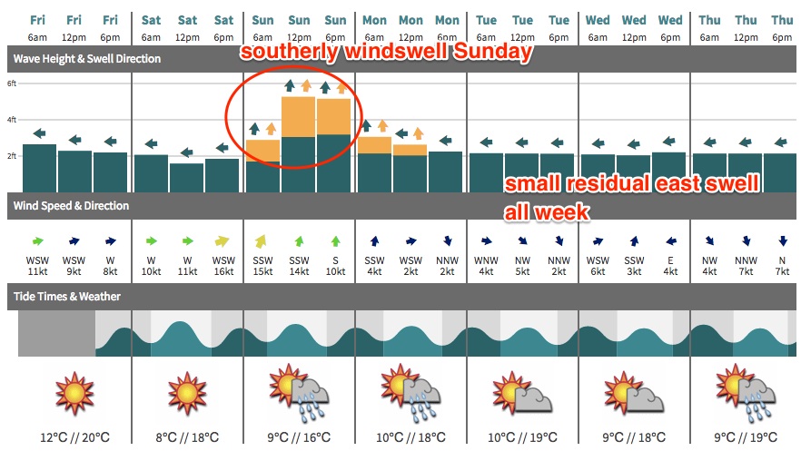
The passing cold front to the south will drive fresh southerly winds across most locations on Sunday, writing off surf conditions at many beaches. We may see an early SW breeze across the Northern Beaches but other than this localised pattern it’s hard to see much quality on the surface across most regions.
Sunday’s waves will consistent of residual E’ly swell from the long-lived Tasman fetch, and a short range southerly swell that could produce bumpy 3-5ft surf at south facing beaches. Quality will be hard to find though, and protected southern corners will be much smaller.
Next week (Monday 13th onwards)
A high pressure system will move in behind Sunday’s southerly change into Monday, allowing the pressure gradient to relax and surface wind speeds to abate and become light and variable. There may be some leftover lumpiness in the water (especially across the Hunter; less so from Sydney south) but on the whole it’s shaping up to be a reasonable day of waves.
The good news is that we’re expecting another pulse of E thru’ E/NE swell from the broad eastward-moving Tasman trough, thanks to today’s impressive developments north of New Zealand. This is generating a quality pulse of swell that probably won’t be in the water at first light but should start to build from mid-late morning onwards, reaching a peak into the afternoon.
As per today’s waves, the swell will be very inconsistent - but we should see occasional 2-3ft+ sets at exposed beaches by late afternoon. Prior to its arrival, Sunday’s south swell should offer workable 2-3ft+ waves at south facing beaches (much smaller elsewhere due to the direction), with an easing trend throughout the day.
The E/NE fetch out north of New Zealand will continue to (very) slowly track eastwards but remain in a positive swell production environment. The only downside is that as it draws further away from the coast, the size potential is slightly reduced and the consistency levels will also deincrease. But, the long range groundswell produced should be of a high quality. Expect 2-3ft surf from this source through Tuesday, a smidge smaller through Wednesday.
We’ll also see several long period south swells make landfall throughout this time, thanks to an active frontal progression south of Tasmania later this weekend and into the early part of next week. Although poorly aligned for our swell window, the sheer breadth of the fetch and its lengthy duration should ensure we see a small spread back up the mainland, favouring south swell magnets with inconsistent 2-3ft sets (building Tuesday afternoon, holding through Wednesday).
Mainly light variable winds are expected all of these days, so conditions should be generally favourable.
Looking further ahead, and we have a more standard seasonal pattern of migrating lows/fronts through the Southern Ocean that should continue to supply moderate intermittent pulses of south swell through the second half of next week and the following weekend. More on that in Monday’s update.
Comments
This morning was pretty darn fun. No one in the water, wind blowing from the west. 4-5ft south swell
Interesting... the southerly doesn't seem to have really made much of an impact across the Sydney/Hunter/Illawarra coast on Sunday, as models had suggested. So conditions were pretty good all day with the new south swell.
Plenty of south swell persisting across Sydney this morning.