Good size for the weekend at south facing beaches

Sydney, Hunter and Illawarra Surf Forecast by Guy Dixon (issued Wednesday 18th May)
Best Days: Each morning, particularly Saturday and Wednesday.
Recap:
A small southerly pulse brought slight relief from this dismal run of undersized surf on Monday afternoon with sets in the 2-3ft range breaking across south swell magnets.
This energy had largely faded by Tuesday morning, with only the odd 2ft set left over along the Hunter, smaller further south with not much more than 1ft breaking along south facing beaches of the Sydney and Illawarra coasts.
This morning, we have seen yet another small pulse, with south facing beaches picking up occasional sets approaching the 2ft range. The morning high tide was masking this energy at first, with improving conditions as the tide dropped.
As for winds, a light offshore breeze persisted all day on Tuesday, leading to clean, buttery conditions all day. This morning, a westerly breeze has persisted allowing for smooth conditions.
This week (Thursday 19th - Friday 20th):
Thursday is likely to see a low point in the size department without any new swell on the forecast. Instead, small, leftover options should be breaking across south facing beaches in the wake of this morning’s pulse, providing little more than 1ft at south facing beaches along the Sydney and Illawarra Coasts. The Hunter will likely highlight the small amount of energy in the water, but I can’t see much more than 1-2ft on the sets, especially with the early high tide playing a role similar to this morning.
On the plus side, conditions are likely to remain clean and groomed throughout the day under a persistent west/northwesterly breeze.
Better prospects for surf come on Friday, generated by a strong front and low which is due to move into our southern swell into Thursday.
Firstly, poorly aligned west/northwesterly fetches look to exit Bass Strait on Thursday, whipping up an initial pulse which is due mid-morning on Friday. However, this first pulses is somewhat insignificant in comparison to the better energy which is due to follow soon after.
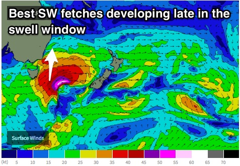 These west/northwesterly fetches over eastern parts of Bass Strait should tend more west/southwesterly with core winds of 40-45kts on Thursday afternoon, followed by better southwesterly fetches with the core of the low southeast of Tasmania. We have been monitoring the movement of this system over the past few model runs, which have been suggesting an eastward motion (even slightly east/southeastward at times), stalling briefly over the central/southern Tasman, before moving northeast once again up the guts of the Tasman towards New Zealand.
More recently, this stalling motion has been downplayed and delayed slightly. It looks as though the best time for swell generation will be a touch too late in our swell window, with the southwesterly 45-55kt core winds lacking the ideal alignment.
Nevertheless, the storm track of this system is leagues above the recent zonal activity we have been enduring, so we can still expect a promising end to the week, with southerly swell building across exposed south facing beaches to around 3-5ft by the late afternoon on Friday, larger across the Hunter and significantly smaller across the less exposed beaches.
The morning is likely to be clean under a southwesterly airflow, however breezes look to tend southeasterly by the afternoon, having an impact on wave quality as things are getting interesting.
This weekend (Saturday 21st - Sunday 22nd):
This energy is likely to peak overnight, somewhere in the 4-5ft range, easing from a similar size on Saturday morning, with the chance of a few left over bigger bombs at the magnets, particularly across the Hunter.
Weaker, broader southwesterly trailing fetches following this system up through the Tasman should maintain a small amount of energy for Sunday, more likely slowing the easing trend rather than providing more size. South facing beaches should ease slowly from around 3ft on Sunday, smaller at less exposed breaks.
Light northwesterly breezes are on the cards each morning, leading to generally clean conditions with only small amounts of left over bump from the day before. It’s definitely worth capitalising on the early session however as seabreezes are expected to develop each afternoon.
Next week (Monday 23rd onward):
Monday is likely to be in between swells, with only small leftover energy breaking across the magnets. Not to worry fresh swell isn’t far away.
The next frontal progression looks to dive down from the Great Australian Bight, contouring the coastline and moving into the southern swell window of NSW on Monday.
Similarly to the last system, west/southwesterly fetches are likely to lead the way, exiting Bass Strait in the afternoon and moving up the NSW coast, with more distant, stronger southwesterly fetches pushing up through the Tasman overnight and into Tuesday.
The core fetches don’t look as strong, just 35-45kts, but are elongated and moving in a slingshotting motion, despite ordinary alignment.
Two pulses are on the cards from this system, initially mid-range energy off the leading fetches building to the 3ft range on Tuesday across south facing beaches, with more size on Wednesday where sets look to build to the 3-5ft range.
Once again, the Hunter is likely to highlight this energy, seeing more size than coasts further south.
Despite being undersized, Monday will be clean under a persistent offshore breeze, associated with the front that is whipping up swell further south. Tuesday should be under a southwesterly breeze for the majority of the morning, tending southeasterly later. Wednesday morning is actually looking fairly promising, with light northwesterly breezes early, tending north/northeasterly from early afternoon.
The situation for both of these swells will be monitored in the coming model runs, with more detail on Friday.
Comments
Guy, would you say 2ft tomorrow morning? Thx mate
Which coast are you on? I'm thinking it'll still be pretty small first thing, building with some workable energy by lunchtime.
Unfortunately we don't currently have much surf as a base level, virtually building from nothing.
In Sydney thanks mate
While it seems there is quite a level of divergence in the models at this stage, do you see any potential in a SE/SSE groundswell originating from southerly/southeasterly fetches below NZ over the weekend, courtesy of the southern flank of the low that looks to stall over NZ? if the GFS model runs true (haha) I would almost say we could be in for a rather enjoyable swell event.