Peak of E'ly swell this weekend, followed by long awaited S'ly pulses next week

Sydney, Hunter and Illawarra Surf Forecast by Guy Dixon (issued Friday 6th May)
Best Days: Saturday, Monday afternoon, Wednesday Thursday and Friday.
Recap:
Easterly trade energy has been gradually building over the past few days and is providing sets in the 2ft range at open beaches today. South facing beaches saw a pulse of long range southerly swell on Thursday afternoon, refracted from SA and Victoria’s large swell earlier in the week.
Sets were breaking in the 3ft range during Thursday afternoon, find slightly to the 2ft to occasionally 3ft range today.
A late morning seabreeze had an impact on wave quality on Thursday, however today, westerly breezes are persisting.
This weekend (Saturday 7th - Sunday 8th) and Next week (Monday 9th onward):
We are due to see a peak in easterly trade energy over the weekend as a result of a westward motion of an east/northeasterly trade fetch earlier in the week.
Open beaches should see sets build to the 3ft range late on Saturday, holding at a similar size on Sunday.
A north/northeasterly fetch looks to develop local late on Saturday night, although not as favourable in the most recent model runs. The development of this fetch looks gradual, while lacking size and intensity during the early stages.
Sunday afternoon is only looking at hints of short range northeasterly energy in the 1-2ft range, holding at a similar size on Monday as winds intensify but with less favourable alignment.
Winds on Saturday morning are looking good with a light west/northwesterly airflow keeping conditions clean. Breezes are likely to swing northerly and eventually northeasterly throughout the morning, so capitalise early for the best conditions.
Sunday is much more likely to be impacted by the wind, with north/northeasterly breezes likely to dominate, with only the outside chance of tending north/northwesterly at times.
Trade-swell is then likely to gradually fade from early next week, with the easing trend slowed only by the westward motion of the fetch which is currently located north of NZ. After receiving a slight reinforcing pulse, the surf should slowly ease to around 2-3ft across open beaches on Monday, further on Tuesday easing from the 2-3ft range.
The afternoon session is looking better on Monday, with breezes tending northwesterly and cleaning up any bumps left over from the persistent northerlies. Tuesday should remain clean throughout the day as northwesterly breezes tend westerly.
The NSW coastline has been suffering under a dormant phase of the long wave trough, but things look to improve from next week as frontal activity fires back up in our swell window.
A west/southwesterly fetch with core winds of 40-45kts looks exit Bass Strait on Tuesday, followed by southwesterly fetches further south providing a fun pulse of much needed southerly swell on Wednesday.
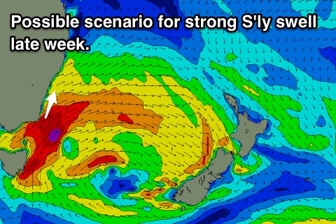 Sets are expected to build to the 3ft range across south facing beaches late in the day, before peaking at around 3-4ft on Thursday morning. We have the potential to see more size on Thursday and Friday as models dliberate the storm tracks of the following fronts. At this stage, there is the possibility that strong south/southwesterly fetches could slingshot up the coast, providing a strong increase in swell for Thursday and Friday.
For now, Wednesday is looking fun, with westerly breezes tending more southwesterly into Thursday.
Have a great weekend.