Small trade-swell peaking over the weekend

Sydney, Hunter and Illawarra Surf Forecast by Guy Dixon (issued Wednesday 4th May)
Best Days: No great days, cleanest each morning.
Recap:
Monday afternoon’s southerly pulse lingered into Tuesday, with south swell magnets picking up sets in the 2ft range. Elsewhere, small lines out of the east were breaking in the 1-1.5ft range, remaining generally clean and workable throughout the day.
Today, swell sources have eased, with options in the 1-1.5ft range becoming pretty tiny. On the plus side, conditions remain clean under an offshore airflow.
This week (Thursday 5th - Friday 6th):
As we are all probably well aware now, the long wave trough is not in a very favourable phase for NSW, but is instead favouring swell windows to our east and west (Vicco on the pump today).
As a result, any frontal activity will be poorly aligned, with the storm tracks generally moving in a southeastward motion - the complete opposite of the north thru northeastward motion we look for.
Pulses of southerly groundswell will be modest as a result, with sets in the 2ft range due on Thursday (larger across the Hunter), with a small reinforcing pulse keeping options in the 1-2ft on Friday morning, easing thereafter.
Our eastern swell window will otherwise have to take up the slack, with a small, slow increase in east/northeasterly trade-swell.
The strongest and most elongated trade fetch has been established from Tuesday but will start to weaken in the coming days. This weakening trend will be countered by the main fetches tending more east/northeasterly and drifting closer to the coast, setting up a slow and steady captured motion.
We are expecting a gradual increase in easterly swell across the open beaches as a result, with 1-2ft sets on Thursday, more so in the 2ft range on Friday.
Conditions look clean on Thursday morning under a west/northwesterly breeze, slowly swinging northerly and eventually giving way to a seabreeze later. Friday looks similar, perhaps becoming seabreezey earlier.
This weekend (Saturday 7th - Sunday 8th) and Next week (Monday 9th onward):
We should see this easterly energy peak late on Saturday and into Sunday, with options in the 2-3ft range, with the occasional bigger set in the mix.
Breezes look light/variable-offshore early on Saturday, putting up very little resistance to a developing seabreeze throughout mid-morning.
A local north/northeasterly fetch looks to develop overnight from Saturday into Sunday, before increasing and straightening up more northerly later on Sunday. This fetch is due to peak in strength into Monday, with northerly fetches just offshore of around 30kts before swinging offshore.
A small amount of northeasterly windswell should build into Sunday afternoon as a result, before peaking on Monday morning with options in the 2ft range, easing thereafter. Due to the local nature of this fetch, the prevailing northerly wind direction has a pretty good chance of impacting wave quality at open beaches.
Monday afternoon is actually looking better than the morning session as breezes swing northwesterly, cleaning things up.
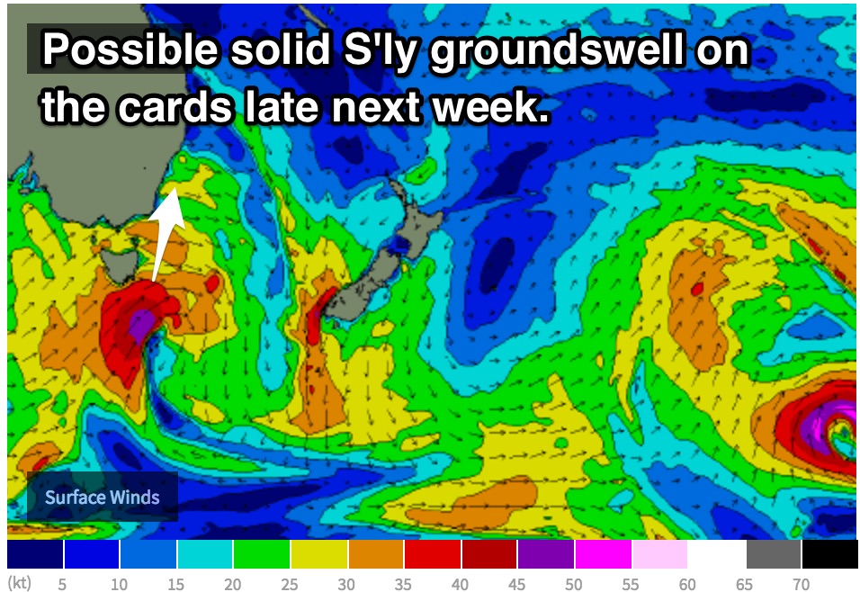
This increasing northerly flow is as a result of a tightening pressure gradient ahead of an approaching front/low, the first decent system in a while. South/southwesterly trailing fetches look to move into the NSW swell window on Tuesday, with good alignment and intensity (up 45-50kts).
Following an initial mid-range pulse, southerly groundswell off this system looks to peak late in the week, with solid sets in the 3-5ft range at south facing beaches. Lets hope models hold onto this scenario.
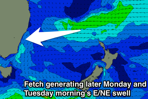
Otherwise, the weekend's easterly trade-swell will be re-inforced by one final pulse later Monday and Tuesday morning to a more consistent 3ft at open beaches. This will be related to a westward moving fetch of E'ly trades moving above New Zealand and then further into the Tasman Sea on the weekend.