S'ly groundswell and offshore breezes on Sunday

Sydney, Hunter and Illawarra Surf Forecast by Guy Dixon (issued Wednesday 6th April)
Best Days: Friday morning, Sunday
Recap:
Early seabreezes have been causing a few issues this week, limiting the chances of a semi-decent wave. The early birds may have been able to make the most of a few workable peaks, particularly on Monday morning under a southerly airflow, although for the most part quality has been lacking.
In terms of size, Monday saw a late kick to around 3ft across south facing beaches, fading throughout Tuesday with a small amount of northeasterly wind swell also in the mix. Today, options have been breaking in the 2ft range.
This week (Thursday 7th - Friday 8th):
A southerly change is still on track to move up the coast late this evening, whipping up a short range southerly wind-swell for south facing beaches. This swell is likely to peak on Thursday afternoon with options in the 3-4ft range.
A longer range southerly groundswell is also likely to be in the mix, building into Thursday afternoon generated by are more substantial front and associated low located to the south of Tasmania overnight.
Core winds of up to 50kts have been blowing over night, with the resultant swell due to peak in the 2-3ft range under a southerly breeze, easing and tending southeasterly as the day wears on. Quality will be hard to find, especially as the swell peaks later in the day.
As the working week draws to a close, options in the 2-3ft range should continue to fill in generated by south/southeasterly fetches off the back side of this low.
The morning session is looking workable under an early westerly breeze, with quality then due to deteriorate as breezes swing northeasterly during the afternoon.
This weekend (Saturday 9th - Sunday 10th):
The better part of Saturday will be forced to rely on small, weak background energy with options in the 1-2ft range as a mix of inconsistent east/northeasterly swell and residual southerly energy fills in.
No matter, a northeasterly breeze looks to increase throughout the day, so unless you’re up for a morning paddle, conditions will be ordinary.
The situation for Sunday’s southerly groundswell pulses has changed slightly since Monday’s notes, speeding things up a touch.
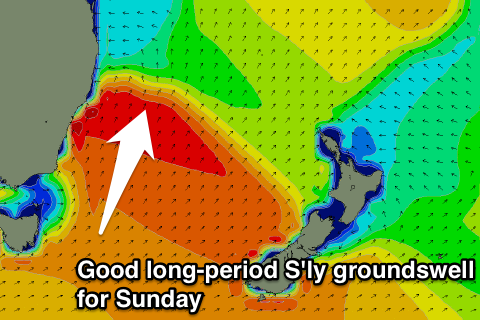
Two pulses of long range groundswell look to fill fill in with quick succession, peaking on Sunday morning with south facing beaches peaking in the 3-4ft range, larger across the Hunter.
The first pulse is currently being generated by an elongated frontal fetch south of WA, with a reinforcing system working on the sea-state activated by the last.
Fortunately, winds look to cooperate for this swell event, persisting from the west/northwest for the majority of the day. Good quality surf is on the cards right along the coast, with the largest options across south facing beaches, smaller elsewhere for the less experienced weekend surfer.
Next week (Monday 11th):
Southerly swell is likely to be the dominant source of energy into next week, with a strong frontal progression moving south of Tasmania on Sunday afternoon/evening, with the resultant swell building Monday afternoon and easing into Tuesday.
Exposed south facing beaches look to pick up sets in the 3-5ft range, with another larger, better pulse shaping up for Thursday.
The early session on Monday is likely to be clean under a west/southwesterly breeze, however as the swell peaks on Tuesday morning, a southerly breeze looks to be established, limiting options somewhat.
More detail on Friday.
Comments
Will be interested in your update Guy. Checked the charts not long after you posted this and just couldn't see a Sunday swell.
Latest runs tend to suggest that it won't be past Tassie shadow until Sunday night, so Monday and Tuesday more likely
Ye' of little faith BF.
The remnants of the frontal progression linked to Sunday morning's S'ly groundswell are currently weakening south of Tasmania.
Check the swell period charts, swell front is pushing into Sydney around 10-11pm Saturday night, with a peak still on the cards Sunday morning.
Cheers Craig.
Not so much a lack of faith, as a lack of information. Charts I'm looking at may not go far enough south to see what you're seeing.
Will await with interest!
Yeah, all our recent strong southerly groundswell energy has come from west of Tasmania, off most charts.