Wednesday the best of the period

Sydney, Hunter and Illawarra Surf Forecast by Guy Dixon (issued Monday 7th December)
Best Days: Wednesday morning.
Recap:
Easterly trade swell has been the primary source of energy over the weekend, providing an inconsistent, but prolonged stream of surf across open beaches. Sets held in the 3ft to occasional 4ft range throughout Saturday and most of Sunday, although few and far between. Even today, the sets are holding in the 3ft range across most coasts.
Each morning offered clean conditions under light/variable-offshore breeze, but have progressively deteriorated each afternoon with the arrival of a seabreeze.
This week (Tuesday 8th - 11th):
We are coming off the back of this easterly trade swell event, however it is expected to continue delivering inconsistent but workable options in the 2-3ft range on Tuesday morning, easing slowly thereafter.
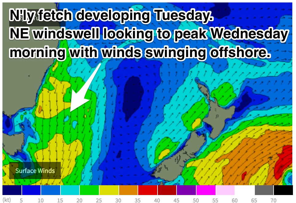 A north/northeasterly fetch is looking to increase along the NSW coast whipping up a short range northeasterly swell to around 2ft at open beaches, however the quality of the surf at these spots is likely to be impacted by gusty local northerly breezes. As a result, the south swell magnets which offer protection from the wind will be the go, particularly in the afternoon when there is more southerly swell.
Meanwhile, small southerly pulse is expected to fill in throughout the afternoon generated by a front which moved over the deep Tasman Sea on Sunday evening. The main swell generating fetch off this system had pretty ordinary alignment (southwesterly 30-35kts) however, its captured nature should allow for a touch more sideband energy, with decent periods peaking at around 15-16 seconds. As a result, south facing beaches are expected to build to the 2ft, with the occasional bigger set in the mix late in the day.
This southerly swell is then expected to peak on Wednesday morning, where south swell magnets should be picking up options in the 2-3ft range, larger across the Hunter. Similarly, the northeast windswell should also be at its largest, peaking at around 2-3ft.
The third and final significant swell in the water for Wednesday will be the remnants of the easterly trade swell, fading from the 2ft range.
The northerly fetch which developed throughout Tuesday will continue to blow during Wednesday, although much weaker and less well aligned. The morning session is looking at light northwesterly breezes leading to clean peaky options at most beaches, tending northeasterly during the day before a southerly change moves through under the cover of darkness.
Most of the significant swell will have dried up for Thursday, with the southerly change not contributing much to the table. You’ll have to make do with residual 1-2ft energy with your small wave groveller.
Similarly, Friday is looking quiet, with only hints of very poorly aligned southerly groundswell at the exposed swell magnets. The spots will be lucky to see 1-2ft sets.
Winds are looking workable, but nothing special on Thursday morning, with a light southeasterly blowing in the wake of the change, tending northeasterly in the afternoon. Friday morning has a good chance of clean surf with light northwesterlies first thing, tending onshore in the afternoon. Some models suggest that the seabreeze boundary will be right along the coast, so even the afternoon may be workable, however the lack of swell still poses issues.
This weekend (Saturday 12th - Sunday 13th):
A gusty southerly change is due to move through during the overnight hours of Friday into Saturday. This change is looking much stronger than Wednesday’s and is expected to whip up a short range southerly wind-swell to around 3ft at south facing beaches, peaking in the afternoon.
Don’t expect much in terms of quality with a moderate southerly breeze tending southeasterly throughout the day.
The short period nature of this swell will allow the size to rapidly ease during the night, with only 1-2ft remnants in the mix on Sunday morning, fading. A northerly fetch then looks to develop along the coast on Sunday, causing a northeasterly wind-swell to build to the 2ft mark.
Again, conditions are not expected to be anything exciting with a northeasterly airflow dominating throughout the day.
Next week (Monday 14th onward):
The outlook for the following looks fairly quiet with the southern swell window doing most of the work. We should only expect subtle ebbs and pulses to around 2ft for much of the week, likely peaking the following weekend.
Comments
hi guys, that little south swell still on track for tomorrow on the south coast?
Still on track for 2-3ft at south facing beaches.
Was definitely some south swell in the water.
Thanks heaps mate