Small period; then a renewal of solid southerly swell

Sydney, Hunter and Illawarra Surf Forecast by Ben Matson (issued Wednesday 29th July)
Best Days: Thurs: early morning for the tail end of this south swell. Sun: small south swell with freshening N'lies. Tues/Wed: building south swell. Thurs, maybe Fri: large south swell.
Recap: We’ve seen an excellent south swell over the last two days that came very close to forecast expectations - if anything nudged a little higher than what was anticipated. Tuesday saw solid 6ft sets at south facing beaches, easing to 4ft today (a little bigger in the Hunter) and conditions have been generally quite good with mainly W’ly winds in the mornings and southerly winds in the afternoon.
This week (July 30 - 31)
The trend for the next few days is down. Our current southerly swell will continue to ease, and while Thursday morning may see a few stray bombs in the 2-3ft range at south swell magnets (smaller elsewhere), it’s expected to become smaller by lunchtime. Conditions will be quite clean though with freshening NW winds.
A small long period southerly swell is expected to clip the coast later in the afternoon (the leading edge may show across the MHL buoy network with Tp around 18 seconds around the middle of the day) but no great size is expected to eventuate at the coast. The source of this swell is an intense polar low located well south of the continent several days ago, and its poor alignment within our acute south swell window - and the very large travel distance - means that only a handful of select locations will see any energy, and even then there’ll be very long breaks between the sets.
I doubt we’ll see much more than an occasional 2ft bomb at a couple of south swell magnets (and across the Hunter) late Thursday afternoon and early Friday, but it’s certainly worth keeping in mind as there are no other swell sources expected.
Otherwise, we’re looking at inconsistent 1ft+ waves at most south facing beaches on Friday and tiny to flat conditions elsewhere, under a W/NW wind that’ll probably ease into the afternoon and become variable.
Also, in Monday’s notes I mentioned that a poorly aligned front pushing east of Tasmania on Friday may generate a small pulse of swell for early Saturday morning. This system has been sped up slightly in the latest model runs, but it’s also been weakened slightly. As such, we may see a very late pulse (after 4pm) of small southerly swell at south facing beaches on Friday, with the last hour of the day possibly throwing up a few 1-2ft waves at the swell magnets. Certainly not worth getting too excited about though.
This weekend (August 1 - 2)
With Friday’s late pulse of south swell speeding up slightly, the downwards trend anticipated for Saturday has also been brought forward. So apart from a small line of lingering swell across the coast (maybe 1-1.5ft at south facing beaches) in the morning, I think Saturday is looking tiny indeed. But hey! It’ll be nice and clean with moderate to fresh W/NW winds.
The good news for Sunday is that the following front pushing through the lower Tasman Sea on Saturday has been marginally upgraded in strength, so we’re looking at a fun south swell for most of the day.
Unfortunately, we’re also looking at freshening pre-frontal northerly winds as a deep, vigorous front/low combo approaches from the west. So, you’ll need to dial into a south facing beach that can handle these winds as they’re expected to become quite fresh and gusty.
As for size, south facing beaches should see occasional 2-3ft sets however the acute southerly direction will result in tiny surf at beaches not completely open to the south. That being said, the Hunter region does pretty well under these scenarios so a few bigger bombs are likely. Just keep in mind that there’ll really only be a few locations raking in the most size from this source due to the source and direction.
Next week (August 3 onwards)
We’ve still got an incredible progression of deep low pressure systems lining up to smack the SE corner of the country this weekend and early next week. However, the initial series of lows look like they’ll remain just west of our swell window, which means we may not see an appreciable amount of size until later in the week, once the storm track finally clears to the east of Tasmania.
At this stage Monday is expected to start off small, with a combo of easing short range south swell from Sunday plus some small, long period refracted energy form the deep Southern Ocean. A strong front crossing the coast during the day will probably whip up a new south swell but I’m doubtful we’ll see much size until the evening, so for now expect small surf to persist all day.
Tuesday and most of Wednesday looks like it’ll be occupied by a building south swell originating from SW gales extending off the coast into the Northern Tasman Sea, so again - we’ll see a large range in wave heights between exposed south facing beaches (anywhere from 3ft in Sydney to 4-5ft in the Hunter), and with much smaller surf at beaches not open to the south.
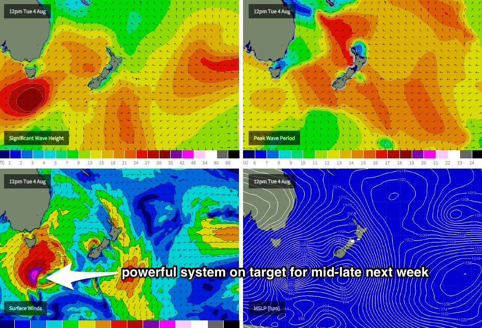
The final low in this progression looks to round the Tasmanian corner late Tuesday and into Wednesday (see chart below) and should kick up a very large south swell for Thursday morning, possibly in the 6-8ft range at south facing beaches, and even larger near 8-10ft at offshore reefs and across the Hunter (due to the associated large swell periods). Large southerly swells will probably then continue through into Friday, but are likely to ease throughout the day.
Most of this period will be accompanied by gusty SW winds, so conditions are likely to be quite challenging at exposed spots. In any case, let’s reassess things on Friday with the availability of updated model guidance as there’s been a little to-ing and fro-ing in the models over the last few days, and we’re likely to see this pattern continue for the next few days until the specifics are firmed up.
Comments
Well, there's the 18+ second (more like 19) long period south swell on the Sydney trace yesterday lunchtime. Shame it didn't produce much surf (as expected) - always nice to see Tp spike like this though.
I saw a two footer! Only one though.
Next weekend, 8th and 9th, looking pretty serious.
I know that Ben counsels not using the 0600 and 1800 model runs, but blimey the EC (?) models for next weekend have one of the biggest swell events for the east coast I have seen for a long long time.
Earlier model runs were showing some good size and possibly light winds from west to sou west, but on the latest run that has morphed into a perfectly directed nightmare gale force southerly monster.
But yeah, I don't give it much chance of coming off like that, but boy, if it did.
Would put a screen shot up if I wasn't too lazy to find out how to do it!
:-)