The southerly regime continues across Southern NSW

Sydney, Hunter and Illawarra Surf Forecast by Ben Matson (issued Wednesday 15th July)
Best Days: Thurs: fun pulsey south swell with good winds. Sun: large S'ly groundswell with light winds and improving conditions. Mon/Tues: easing S'ly groundswell with light winds tending NW. Wed: new long period S'ly groundswell with good winds.
Recap: Easing S’ly swell through Tuesday with initially some sizeable sets across the Hunter, ahead of a late reinforcement in secondary south swell that’s persisted for much of today. Great conditions both days with offshore winds.
This week (July 16 - 17)
Today’s southerly swell is expected continue trending slowly downwards into Thursday morning, however a new pulse of south swell is expected to arrive during the day.
This was generated by a low that formed SW of New Zealand’s South Island on Tuesday, in associated with the broad pattern occupying the Tasman Sea this week. However, the low wasn’t particularly strong and it hasn’t remained in the swell window for very long, so its influence will be brief across the coast.
That being said, I think the swell models are undercooking the size potential from this system (they're calling just 2ft at south facing beaches all day Thursday). Whilst the early morning is likely to dip in size from today, I think the arrival of this new swell (from about mid-late morning/lunchtime in Sydney, earlier on the South Coast) should deliver occasional 3ft+ sets at south facing beaches through the afternoon, with bigger bombs in the Hunter. Expect smaller waves at beaches with less southerly exposure, and with mainly W’ly winds tending NW during the day, most open beaches should be nice and clean so it’ll be well worth an afternoon session.
Friday is a completely different story. A developing low pressure system immediately east of Sydney overnight Thursday will drive strong W/SW (pre-dawn) tending S/SW winds across the coast, with a lot of rain as well at times. The latest model guidance has pulled this system right in to the coast so the trailing fetch will probably be straight south in direction, and also short in length - but regardless there’ll eventually be some big waves at exposed south facing spots (6ft, maybe 8ft by late afternoon and very wind affected).
Protected spots will therefore be your only option on Friday with much smaller surf inside sheltered southern corners due to the swell direction. Keep in mind that the early morning will probably be smaller, and winds are likely to be more favourable at this time - but don’t let this deceive you. It’ll be nothing but an upwards, messy trend throughout the day.
As a side note - it’s still 50/50 whether this low will be a Tasman Low or an ECL. Latest model guidance whisks it away rather quickly to the east (which suggests a Tasman Low) but modelled rainfall totals look reasonably good.
This weekend (July 18 - 19)
A cold front racing up through the lower Tasman Sea from the Southern Ocean looks like it’ll become absorbed into the latter stages of Friday’s coastal system. This is great for surf potential (as it’ll renew a reasonably solid round of energy from the south) but it also invigorate the southerly airstream across the coast.
Therefore, Saturday looks pretty windy with fresh southerly winds and 4-6ft surf at south facing beaches (protected spots will be much smaller but cleaner).
Sunday looks much better, thanks to a large high pressure system ridging in from the west. This will rapidly ease the local southerly flow, and create regions of light W/SW winds too, although there may still be some leftover lump and bump across the surface.
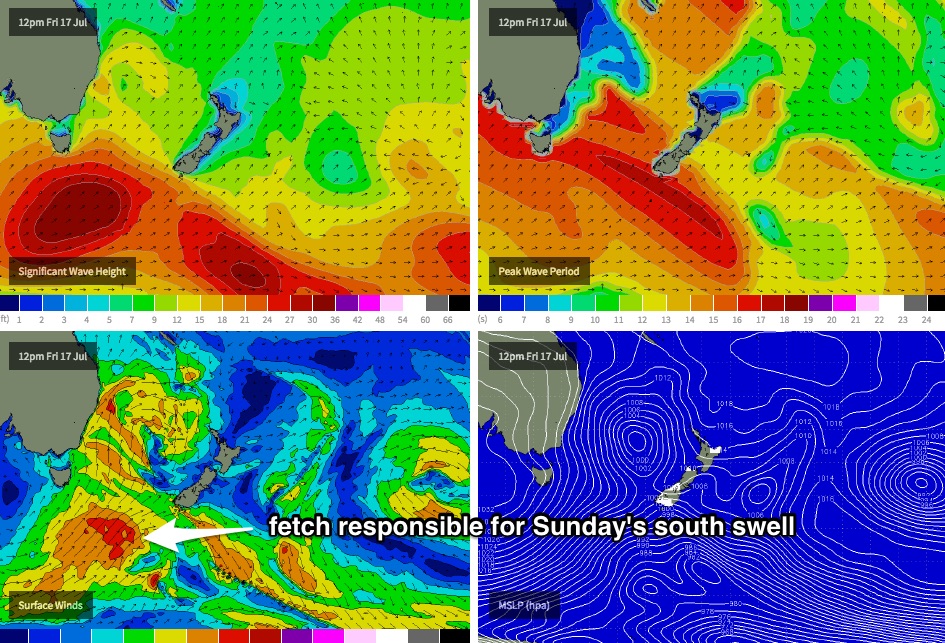
More importantly, we’ve got a series of strong southerly groundswells on the way, generated by a succession of intense polar lows developing off the ice shelf over the coming days. They’re expected to project up through the Tasman Sea (see chart below) and should supply plenty of surf at south facing beaches in the 4-6ft range for most of Sunday. In fact, due to to large swell periods associated with very strong core wind speeds around these polar lows, we may see occasional bigger waves at offshore bombies and across the Hunter.
So, there’s no shortage of surf expected this weekend but I’d recommend Sunday - great waves are likely at most coasts.
Next week (July 20 onwards)
Monday and Tuesday are looking very good across Southern NSW with easing southern energy from Sunday's pulse, and mainly light winds tending NW as the high pressure system moves slowly east.
Another deep polar low off the ice shelf over the weekend looks set to generate a very powerful, albeit distant southerly groundswell that’s modelled to arrive across the coast later Tuesday and provide a full day of very inconsistent, long period south swell through Wednesday. It’s still some time away so I don’t feel confident in size estimates, but as an early ball park somewhere in the 4ft range looks like at south facing beaches. More on this in Friday’s update.
Comments
Hmmm. Winds were W'ly at dawn across the Sydney region, but they're now tending S'ly from Cronulla to the Northern Beaches.
An easy assumption would be that the developing low off the coast is taking hold much earlier than expected (southerlies weren't expected until tomorrow morning) however a quick scan of the obs to the south - in the vicinity of the region where the low is expected to initially develop - shows that winds are SW at Bellambi, W/SW at Kiama and Point Perpendicular, and NW tending W'ly at Montague Island.
And to the north of Sydney, winds are W/NW at Norah Head and NW at Newcastle.
So, this doesn't quite make sense. Perhaps we've got a brief mesoscale low pressure system across the Sydney region - if this is the case we should see a return to the broader westerly flow across Sydney beaches around lunchtime or early afternoon.
Thanks for the forecast mate.
Winds look strong this weekend - do you think we'll be blown out down south or will there be enough W in it?
Saturday looks fresh southerly just about everywhere in southern NSW. We may see some pockets of early SW winds but I wouldn't plan a road trip.
Sunday looks better with light variable winds everywhere except the Hunter. They'll probably tend W/SW early but without much strength, it may not be enough to properly iron out the lumps from this afternoon's and tomorrow's winds.
But Sunday is the pick for sure. Plus there'll be a new southerly groundswell in the water too.
Looking small but fast at Manly this morning!
Still looking reasonable across the Manly stretch despite the terrible conditions at exposed beaches.
Building cooks 4-5ft this arvo with some bombs