Easing S/SE swell all weekend, strong S'ly swell for Wednesday

Sydney, Hunter and Illawarra Surf Forecast by Ben Matson (issued Friday 5th June)
Best Days: Sat/Sun: fun, easing S/SE swell with generally good winds. Tues: keep an eye out for a very late pulse of new S'ly swell (low chance for now). Wed: strong S'ly swell. Thurs/Fri/Sat: moderate, easing S'ly tending S/SE swells.
Recap: Pumping S/SE swell on Thursday with 6-8ft sets at exposed spots with light offshore winds for much of the day. Wave heights have eased overnight but conditions have remained excellent; swell magnets were still pulling in 3-5ft waves early morning but it’s easing slowly in size.
This weekend (June 6 - 7)
No major surf for the weekend but there should be good waves at south facing beaches both days. The currently S/SE swell will continue to ease, but will be reinforced by a series of smaller, distant S/SE sources.
These energies will originate from a frontal passage extending from the ice shelf up into southern New Zealand over the last few days, which, while not favourably aligned within our swell window, should still maintain inconsistent 3ft sets at south facing beaches on Saturday, easing to 2-3ft Sunday morning and 2ft by Sunday afternoon. There’ll be long breaks between sets too, and it’ll be smaller at locations not completely open to the south, so you’ll need to be patient.
However, conditions should be pretty good both days. A weak low pressure trough developing off the North Coast may instigate a light W/SW breeze at times across the Hunter on Saturday but for the most part winds look to be variable across Southern NSW. On Sunday we’ll see freshening NW winds as a series of cold fronts approach from the south-west.
As such, aim for Saturday morning for the biggest and best waves as it’ll really only be suitable for exposed south swell magnets on Sunday. Of the entire southern NSW coast, the Hunter region is likely to see the best waves of the weekend as it’s usually very reliable from this swell direction.
Next week (June 8 onwards)
We’re looking at a couple of lay-days early next week. A vigorous frontal passage across Tasmanian longitudes over the weekend looks to be too zonal (west-east) in alignment to favour Southern NSW however exposed south swell magnets may pick up a few stray 1-2ft waves on Tuesday (Monday will see very tiny residual energy from the weekend, only at south swell magnets).
Conditions will however be very clean both days with freshening NW winds Monday and early Tuesday ahead of a W/SW change Tuesday lunchtime that’ll trend SW late afternoon.
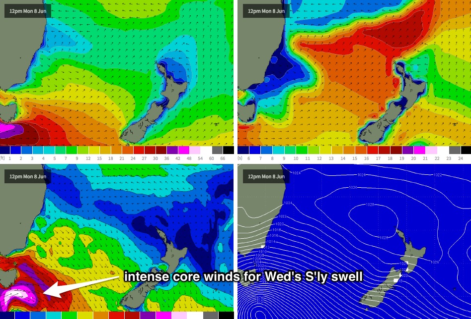
A much more intense low/front combo will cross Tasmania late Monday, with winds of 60kt+ expected to impact the southern part of the state (see chart below). The strongest winds within this system will be somewhat unfavourably aligned for Southern NSW however the trailing fetch looks pretty good - very strong, quite broad and reasonably aimed within our acute south swell window.
We’ve actually got two swells expected from this pattern, however the first - a small, directional south swell originating from W/SW gales exiting eastern Bass Strait - may not arrive until very late Tuesday, so it could very well be rendered useless for surfing purposes (as the bulk energy is expected overnight). This fetch should produce 2-3ft+ waves at south facing beaches - and bigger in the Hunter - but I wouldn’t expect anything to arrive before about 3-4pm Tuesday at the earliest - it’ll be a late session at best, if anything shows at all. I'll revise this estimate in Monday's notes.
This swell should be well and truly in the water for Wednesday morning, but it’ll likely be overshadowed by a bigger S’ly swell originating from the primary fetch south of Tasmania (leading edge may display 17-18 second swell periods early Wed morning, but there won't be much size with it). This is expected to reach 4-5ft at south facing beaches throughout the day, however the Hunter Coast usually responds really well to these synoptic setups and I wouldn’t be surprised if set waves push north of 6ft to almost 8ft at times. As always, expect smaller surf at beaches not completely open to the south.
As for local conditions - they're looking pretty good on Wednesday with early light W/SW winds trending SW during the day.
Wednesday’s swell will then ease through Thursday however we’ll see smaller reinforcing S/SE swells to finish the working week, originating from secondary lows within the progression as it tracks towards New Zealand longitudes.
Beyond this there are no signs of any major weather systems but it’s very likely that well see the development of another strong series of cold fronts through the Southern Tasman Sea later next weekend or early in the following week, as is common for this time of year.
So all in all, we’ve got another strong week of south swell ahead. Get stuck into it! Have a great weekend, see you Monday.