Lotsa south swell, plus some NE potential

Sydney, Hunter and Illawarra Surf Forecast by Ben Matson (issued Monday 2nd February)
Best Days: Wed AM: early window before a S'ly change hits. Wed PM/Thurs: outside chance for some small NE swell at swell magnets. Sat: fun south swell with light winds.
Recap: Large southerly swell continued through the weekend, initially 6-8ft at south facing beaches on Saturday but down to 4-6ft on Sunday and just 3ft this morning. Winds were generally good both mornings on the weekend (before moderate sea breezes kicked in) but freshening southerlies today have caused a deterioration in surface conditions at most locations.
This week (Feb 3 - 6)
The ridge building along the NSW coast today will weaken slightly into Tuesday so we can expect southerly winds to slowly ease throughout the day. This should gradually improve surf conditions although it’ll probably remain below average in general. There’s an outside chance for a period of light SW winds at dawn but if this occurs, it’ll probably be confined to a handful of coasts (i.e. Northern Beaches).
Tuesday’s surf will mainly consist of slightly easing energy from today, so biggest at south facing beaches with perhaps some early 3ft sets at swell magnets. Keep your expectations low.
Wednesday looks pretty ordinary. A weak trough attached to a deep Southern Ocean low tracking through the southern Tasman Sea will push along the coast, restrengthening the southerly airstream. Just ahead of it, we’ll probably see a brief period of SW winds but this will probably be confined again to the Northern Beaches and perhaps the Hunter region (although Newcastle may still be under the influence of the ridge).
A small new pulse of southerly swell from a weak front that just nosed into the southern Tasman Sea today should maintain 2-3ft waves at south facing beaches, but you will have to be early to score anything worthwhile.
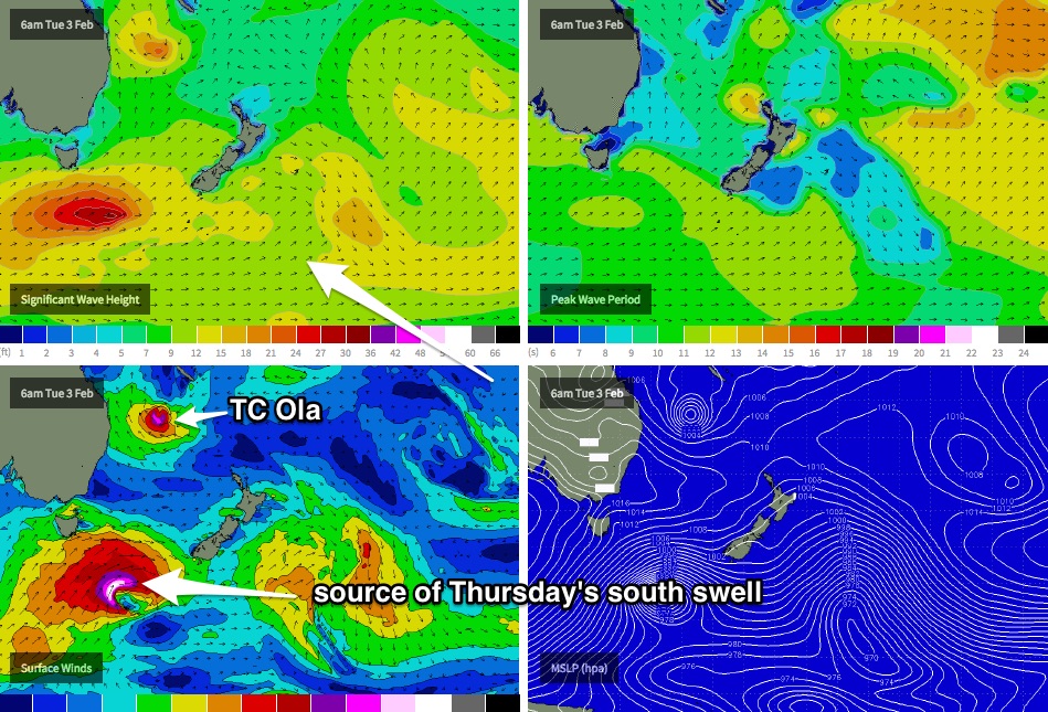
The swell period charts are showing a strong 'swell front' from the north-east arriving on Wednesday, originating from Tropical Cyclone Ola which formed on Saturday and is currently Cat 3 status, just SW of New Caledonia.
However, I’m not expecting much swell from TC Ola at this stage, mainly due to the short fetch length that has developed inside our swell window, and the position of TC Ola relative to the swell shadow offered by the Hunter curve.
However, there are a couple of aspects about TC Ola I do like, such as the projected storm track over the next few days (somewhat of a beeline towards Southern NSW) and its forward speed (not too fast, maybe even ideal enough to create a captured fetch scenario).
Nevertheless, right now I don’t think we’ll see any great size from TC Ola in the short term, perhaps two or maybe three feet on Wednesday afternoon at NE swell magnets (and much smaller in the northern Hunter). There’s a chance for some bigger waves further along the South Coast which is more open to this swell direction but I wouldn’t hedge any bets on it.
In any case we’ve got a stronger south swell due Thursday morning, originating from the parent low/front to the weak trough that’s expected to cross the coast on Wednesday.
This system looks impressive, with a broad SW fetch spanning the entire southern Tasman Sea down to polar latitudes (see chart below), and should provide a brief pulse of 4-5ft surf for exposed south facing beaches on Thursday (maybe a few bigger bombs in the Hunter). Fresh S/SE winds associated with a building ridge will however ruin surf quality at most exposed locations.
At the same time, we’re likely to be close to the initial peak of NE swell from TC Ola on Thursday morning. At the present time I don’t have any data to justify much more than what we’re expecting by late Wednesday, which is: inconsistent 2-3ft sets at exposed NE facing beaches between Sydney and Wollongong (smaller in the Northern Hunter) but with a chance for a few bigger bombs on the South Coast. Size will probably ease during the day, although with a strong S’ly swell in the water it may be hard to distinguish the infrequent NE swell at open beaches anyway.
However I gotta say that confidence for swell potential from TC Ola is rather low, for many reasons - first and foremost because cut-off systems, of Cat3 strength, in this neck of the woods, are extremely rare. So we don’t have any benchmarks to work against. Keep your expectations low and be pleasantly surprised if something eventuates.
Thursday’s south swell will then be supplemented throughout Friday by a second pulse of south swell from a secondary frontal system, with wave heights expected to reach a similar size (3-4ft south facing beaches). The timing on this pulse is not yet clear, it may not be until the afternoon. However, local winds will probably be similarly annoying from the S/SE as per Thursday. The NE swell from TC Ola (if it shows up) is also expected to continue to trend downwards during this time, so expect very small surf from this quadrant.
Also, it’s worth pointing out that the wind outlook (and also the NE swell potential) for Thursday and Friday hinges on the eventual track of TC Ola, which will probably push close enough to the mainland to influence local winds to some degree. This will be much greater felt on the Northern NSW coast than the Southern NSW coast, but we are still likely to feel the onshore effects across Sydney, Hunter and Illawarra coasts (the South Coast will probably fare better). As such, there is a possibility that there could be a slight condition upgrade in Wednesday’s notes.. stay tuned for that.
This weekend (Feb 7 - 8)
At this stage TC Ola is expected to focus its alignment towards the Far Northern NSW/SE Qld region through the second half of this week. So right now it’s not expected to have a direct influence on Southern NSW's surf this weekend.
As such, the weekend will be relying on swell sources from the south. Friday’s new swell should hold into Saturday morning with inconsistent 3-4ft sets at south facing beaches easing during the day. Smaller waves are expected on Sunday, and winds both days should be fine in the morning under a light//variable pattern ahead of afternoon sea breezes.
Next week (Feb 9 onwards)
Still some more tropical activity expected to pop up on the long term charts for the next little while, which suggests there could be more east or north-east swell in the pipeline for the following week. but with the model guidance showing no general agreement, we’ll have to give it a few more days to assess the long term options.
Comments
.
Can someone out there tell me when Sydney had the last genuine cyclone swell not
a trade swell a real NE cyclone swell? I know we use to get them.
I would say Cyclone Ita last year. There were good weeks generated from the Tasman but the last proper Cyclone swell was last year in april with Cyclone Ita which generated good waves for about four days in the Sydney Region.
Ok I think I was in Bali. The only one I can remember was March 2006, huge and good
and I was in Hawaii for the worse 2 weeks of rain and flat surf in the islands history I think