Average short term, still potential for an active next week

Sydney, Hunter and Illawarra Surf Forecast by Ben Matson (issued Wednesday 4th June)
Best Days: No great days.
Recap: E/NE swell held its size across southern NSW on Tuesday, a smidge more than was expected on Wednesday’s notes (2-3ft all day against a forecast of 2ft+ easing). Size has backed off today though, and a small southerly swell is also showing up at swell magnets, originating from a moderate front existing eastern Bass Strait (both swells are weak in the 1-2ft range). Conditions have been clean with offshore winds for the most part but light to moderate southerly winds are now developing across the coast.
This week (June 5-6)
Nothing major to finish the week. A broad, stationary high in the Bight is directing a moderate southerly wind across southern NSW and it’ll keep a lid on quality for the coming days.
In fact these southerlies will freshen through Friday as a trough deepens across the western Tasman Sea, and this will in turn generate a short range southerly swell that’s expected to build at exposed south facing beaches throughout Friday. However these beaches will be bumpy under the southerly breeze and other locations not open to the south will be very small. All in all not worth working around unless you’re desperate.
This weekend (June 7-8)
The various computer models on which we base our forecasts went a little skewy this morning, which has thrown a curveball into the long range forecast regarding next week's projected ECL (which I’ve been discussing since last Friday).
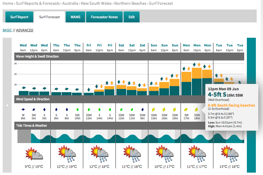
However, the most recent data available (18Z GFS) has come back into line, reiterating Monday’s forecast for a strengthening short range S/SE fetch just off the coast over the weekend that should gradually ratchet up wave heights at south facing beaches - see the graph below.
Saturday should start off similar to late Friday (2-3ft sets at south facing beaches) however Sunday afternoon looks like it’ll offer the biggest surf with south facing beaches expected to reach 4-5ft, and smaller waves elsewhere.
Unfortunately it looks like conditions will be pretty ordinary due to the presence of these strengthening southerlies across the coast (that’ll significantly deteriorate wave quality at exposed breaks) however there will certainly be some waves around and there’s a reasonable chance for brief periods of SW winds across certain pockets of the coast. Let’s take a more detailed look at this in Friday’s notes.
Longer term (June 9 onwards)
As mentioned above, the computer models have wigged out a little in the last 12 hours regarding the projected developments of an ECL early next week. Although the most recent GFS run is back on track (predicting 6-8ft at south facing beaches on Monday, see below), the overall confidence levels for this event have been wound back a few notches. Right now all of the ingredients are still there for a really significant swell event during the first half of next week but we’ve simply gotta give the models a few more days to breathe before committing to anything. Let's see how things are looking on Friday.