South for the Sydney win

Sydney, Hunter and Illawarra Surf Forecast by Ben Matson (issued Monday 5th May)
Best Days: Tues: moderate south swell with good winds in the morning (may get a little funky in the south). Wed: another solid south swell, but with tricky winds. Thurs: slightly larger south swell, but again with tricky winds (should improve slowly though). Fri: easing south swell with great conditions.
Recap: What a weekend! Tiny waves Saturday, with a strong building south swell on Sunday that seemed to follow the script reasonably well. Dawn revealed near-flat conditions along the Northern Beaches but within a few hours small clean lines were pouring into south swell magnets. Wave heights were overhead by lunchtime and through the mid-late afternoon 6ft+ bombs were observed at many exposed beaches. In fact one offshore bommie on the South Coast was considerably larger than that, closer to 12-15ft (we’ll have some images on the site tomorrow to qualify these claims!). Winds were straight offshore all weekend, but at strength - so it made for challenging conditions at exposed locations.
Sunday’s swell seems to have held nicely into this morning, with 6-8ft+ bombs reported in the Hunter but smaller 6ft surf across exposed breaks in the Sydney region (still some big sets on the South Coast though). Winds have fortunately throttled right back so conditions are nice and clean.
This week (May 6-9)
Anyone a Souths fan? Good news for you - we've got plenty more south swell on the way.
There’s no real change to Friday’s notes, with our current swell easing slowly through Tuesday (3-5ft south facing beaches, bigger in the Hunter but smaller at beaches not open to the south) ahead of two pulses of fresh south swell for Wednesday and Thursday. In fact, the South Coast may pick up Wednesday’s swell a little earlier, i.e. late Tuesday afternoon.
Tuesday’s winds will be good in the morning across the Illawarra, Sydney and Hunter regions but a fresh southerly change is expected in Sydney around lunchtime (earlier on the South Coast). So make the most of the early session.
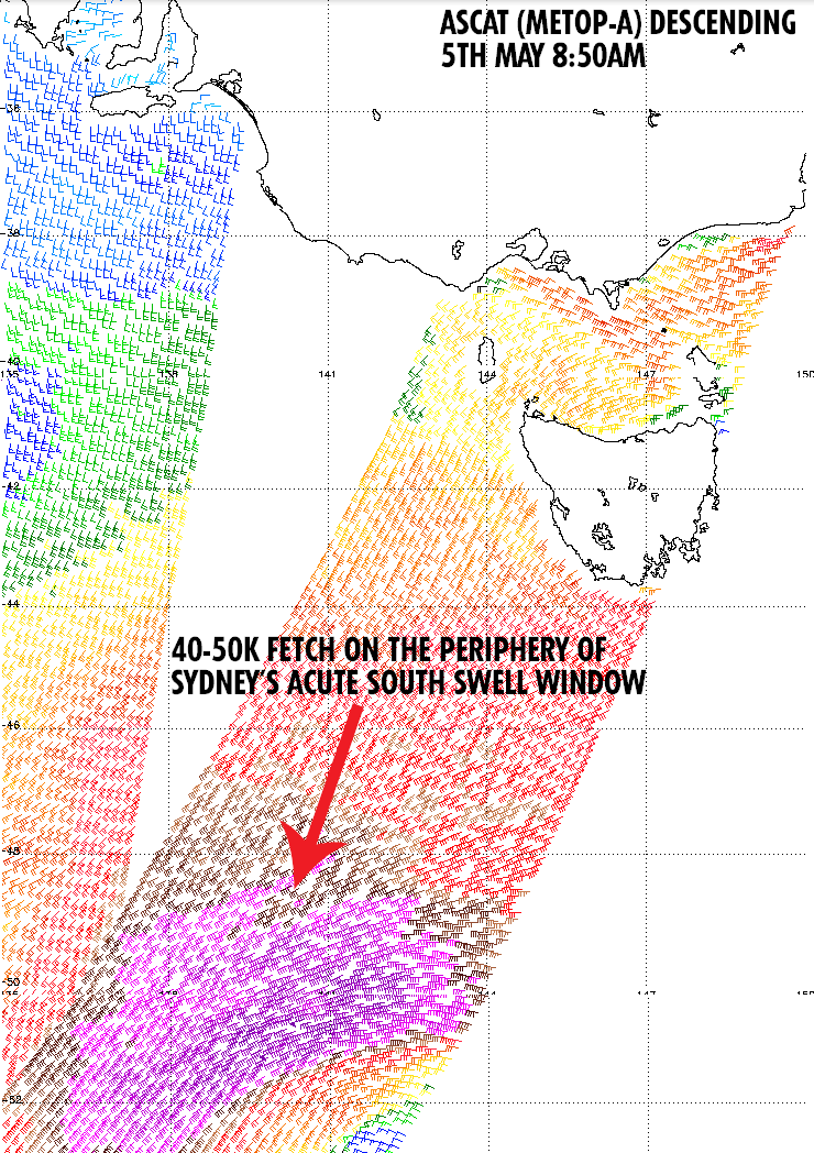 Wednesday’s building swell will be generated by a strong front presently crossing the Tasmanian coast. It’s a strong, dynamic system but is poorly aligned for the Australian East Coast (quite SW-NE in orientation through the lower Tasman Sea) so swell prospects will be down a bit compared to a more meridionally aligned fetch. Still, just prior to this front pushing across Tasmanian longitudes, it was packing a punch in the Southern Ocean with 40-50kt winds sitting just outside the periphery of our acute south swell window (as you follow the appropriate Great Circle path). See the image to the right which shows where the fetch was this morning.
The resulting peak swell periods from this part of the storm will be quite large - say, 17-18 seconds - but only a small percentage of energy will be contained within this spectral range as it arrives overnight on Tuesday. Instead, most of Wednesday’s increase will originate from the marginally weaker remnants of the front as it rounds the corner into the lower Tasman Sea overnight into Tuesday morning.
The other good news is that this fetch will be working on an already active sea state generated by the weekend’s Tasman Low, which means we should see a decent increase across the coast into the 5-6ft range at south facing beaches (smaller 3-4ft waves at open beaches, 1-2ft inside protected southern corners).
Winds are however looking dicey on Wednesday as a high in the Bight and a low in the Tasman directs fresh southerly winds across the region. There’s an outside chance for a brief period of SW winds at some locations (probably just the Northern Beaches, which I’d give a 40% possibility) however in general you’ll have to aim for protected spots for the cleanest waves.
Of more interest is yet another strong S/SE swell due to fill into the region on Thursday. This pulse will be generated by a small secondary low pressure system located well to the S/SW of New Zealand today (in the vicinity of Macquarie Island) which is expected to merge tomorrow morning with the tail end of the aforementioned front tracking into the lower Tasman Sea. The interaction between these two systems will re-strengthen a fetch of storm force southerly winds later Tuesday and into Wednesday morning between New Zealand and Tasmania but well to the south, in the Southern Ocean.
Again, this fetch will be working on an already active sea state and I think there’s a good chance that this particular swell event may punch slightly above its weight across exposed beaches - our model forecast has peak wave heights in the 6ft range but I think it’ll probably be somewhere closer to 6-8ft at south swell magnets. The timing isn’t 100% right now but there’s a good chance it’ll be into the South Coast before dawn, arriving into the Sydney region within a few hours of sunrise.
As for Thursday's winds - we’re unfortunately looking at a lingering moderate+ S/SE breeze however there’s again an outside chance for a period of SW winds across a couple of locations (mainly the Northern Beaches). So for the most part this swell may be spoiled however I’ll reassess this in Wednesday’s update. If there is a positive, it is that the overall synoptic trend suggests winds will slowly abate during the day so let's hope future model run updates pushes these develops a little further ahead.
Friday is looking excellent with a strong but slowly easing south swell and a light variable wind all day.
This weekend (May 10-11)
With such a great week of waves on the charts, surely you didn’t think it’d hold through the weekend too?
Yes, unfortunately all of this swell activity will continue to ease throughout the weekend. We’ll still see some fun peelers on Saturday at exposed swell magnets and winds will be NW early, tending N’ly during the day. Even smaller surf is expected Sunday with similar winds.
Next week (May 12 onwards)
Looks like we’ll see a new front push across Tasmanian longitudes later int he weekend that may bring about a renewal of south swell for the start of next week, but that’s still quite some time away. Let’s take a closer look on Wednesday.
Comments
Hey Ben can I ask is there a reason in the Sydney reports often the northern beaches is lucky enough to get early sou'westerly winds?
Great forecasting Ben - the weekend pretty much went to plan. Pumping! Loving the detail in the notes. I look forward to them every Mon, Wed & Fri!!
It seems to be due to presence of the hills and mountains just behind the beaches with cold air sinking down the slope towards the ocean, enhancing the land breeze effect, swinging a southerly gradient more westerly.
Cronulla and the Eastern Suburbs don't have the hills or mountains close by, but head just south to the Coal Coast and you'll see the land breeze similar to the Northern Beaches working again.
It's common to see SW winds on the Coal Coast, S'ly winds in Cronulla and then SW winds again around the Northern Beaches.
thanks Craig good to know
Once again, Winds were W'ly on the Northern Beaches but S/SW across the Eastern Beaches and Cronulla. The Hunter is doing well right now with W/SW winds on the Cenny Coast and NW winds in Newcastle too, but it won't last long - Wattamolla (just south of Cronulla) has 20-30kt S'ly winds that'll spread northwards over the coming hours.
Cronulla point went off on sunday 4 ft with 6ft+ sets
Cronulla has no good waves everybody knows that.
Seems a few latest charts have it holding pretty solid through friday, where previously it was called to drop off fairly steadily....
I'm planning on a trip south on Friday, winds should have turned just nicely on Friday arvo with my expectations that the swell hanging in there, as per gibbsy's comments.
And the early on Saturday could be pretty sweet also.
Though not quite as good as the charts were suggesting this morning, at least the ones I was looking at.
maybe too solid for some spots methinks....
Incoming from the south.
Looks like the swell front is somewhere between Crowdy and Coffs judging from the buoy array.
That photo is about 20ks south of me and I get south swells so
where is the swell?????????????????????????????????????????????