Strong swell to end the week

Southern Tasmanian Forecast by Craig Brokensha (issued Wednesday May 21st)
Best Days: Friday, Saturday working the winds
Features of the Forecast (tl;dr)
- Small W/SW swell tomorrow with N/NW tending E/NE winds
- Mod-large W/SW groundswell Fri, easing later, further Sat
- Moderate N tending fresh NE winds Fri, fresh N/NE tending W/SW later AM Sat, then W/NW later
- Small to tiny Sun with N winds
- Solid stormy swell likely Tue/Wed with strong SW winds Tue, W/SW Wed
Recap
The swell was still a good 2ft+ through yesterday, holding most of the day with this morning backing off to a smaller 1-2ft.
This week and next week (May 22 - 30)
A small low moving through our swell window through yesterday has generated a small pulse of W/SW swell that should be seen later today, peaking tomorrow to 1-2ft under N/NW tending E/NE winds.
This is the lemon next to pie though, with our larger, W/SW groundswell due to come in much stronger Friday morning.
The ‘bombing’ low linked to it is currently weakening to the south of Western Australia while still generating fetches of W/NW gales.
Before the low weakened we saw a tight, very intense fetch of storm to hurricane-force winds, abating slowly through yesterday as the low expanded in scope and pushed east.
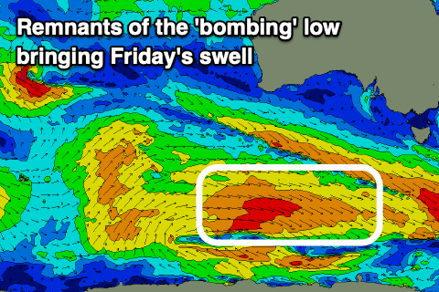
This has generated a large, long-period W/SW groundswell that should peak through Friday to a strong 3-5ft across Clifton, though mostly in the 4ft range and with favourable N tending fresh NE winds.
The swell is due to start easing into the late afternoon, with Saturday likely coming in at a smaller 2-3ft, smaller through the day.
Winds are tricky with gusty N/NE winds, shifting W/SW later morning but then possibly W/NW later.
Sunday looks small to tiny, as does Monday before a strong cold outbreak moves in and across us from the west later in the day but more so Tuesday.
Yesterday this outbreak was looking more significant and better for an oversized, stormy S/SW swell but the models have cooled off a little on the polar fetches, with most of the storm activity sitting too far north of our swell window.
With the dynamic nature of the coming swells you’ll have to check back Friday for a clearer idea on the local winds and sizes as GFS is much stronger and better than the more reliable ECMWF.