Easing surf ahead of some new swell into the weekend

Southern Tasmanian Surf Forecast by Craig Brokensha (issued Wednesday October 11th)
Best Days: Tomorrow morning for the keen, early Friday, Saturday morning, Sunday morning, Monday morning, Tuesday morning
Features of the Forecast (tl;dr)
- Easing S/SW groundswell tomorrow with N/NW tending NW winds, shifting SW late
- Small mix of W/SW and S/SW swells Sat with W/NW tending SW winds mid-morning
- Moderate sized SW swell building Sat with fresh W/NW tending strong SW winds
- Peak in SW swell Sun with fresh W/NW tending strong SW into the PM
- Easing swell Mon, mixed in with an inconsistent W/SW groundswell with W/NW tending SW winds
- Smaller Tue with N/NW winds ahead of sea breezes
Recap
Monday’s swell eased back into yesterday and conditions were a little lumpy/bumpy under variable morning winds. A new pulse of S/SW groundswell expected later yesterday has peaked this morning on forecast with good 2-3ft sets across Clifton under better winds.
Sea breezes are now making a mess of it along with a drop in swell.
This week and weekend (Oct 12 - 15)
The current swell is due to ease back through tomorrow with tiny 1-1.5ft leftovers due for the keen under a N/NW tending NW breeze, giving into a late SW change as a cold front clips us.
This front will bring with it a small pulse of weak W/SW swell Friday to 1-2ft, mixed in with some polar swell from a late forming front today.
The window for clean conditions looks minimal though with a dawn W/NW breeze due to shift SW mid-morning and strengthen.
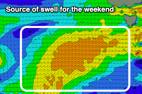
Another more robust polar frontal system will be responsible for Friday morning’s change, with a great fetch of strong winds being projected up through our south-western swell window through Saturday.
A moderate sized + SW swell is due to build Saturday and peak Sunday, coming in at 4ft+ across Clifton.
Local winds look workable through this period and WNW Saturday morning with 2ft or so of swell, shifting strong SW into the afternoon , then W/NW again Sunday morning, shifting SW into the afternoon. Similar W/NW tending SW winds are likely on Monday as the swell eases, but we’ll confirm this Friday.
It’s worth noting that there’ll be an inconsistent W/SW groundswell in the mix Monday morning, though generated by a distant polar low that’s currently around the Heard Island region.
Into the rest of next week, a strong groundswell is likely Thursday, generated by a strong low firing up to the south-west of us early next week. More on this in Friday’s update though.