Poor run of weather and surf until next week

Southern Tasmanian Surf Forecast by Craig Brokensha (issued Wednesday May 4th)
Best Days: Possibly Friday arvo/evening for savvy surfers, Monday
Features of the Forecast (tl;dr)
- Inconsistent mix of moderate sized W'ly swells tomorrow but with moderate SW tending strong S winds
- Moderate sized, junky S/SE windswell Fri with strong S/SE-SE tending light E winds
- Small mix of swells Sat with fresh SW winds
- Good, mid-period SW swell Sun with fresh SW winds, easing
- Easing SW swell Mon with N/NE tending variable winds
Recap
Small 1-2ft waves the last two days with a bit of rain today as the remnants of a strong frontal progression forms into a broad, multi-centred low across us and Victoria.
Tim Bonython's Australian Surf Movie Festival is coming up real soon, with incredible new 8K footage of Nazaré, Jaws, Mavericks, Teahupo’o and more, that simply HAS to be seen on the big screen. Get your tickets to the Hobart show (Village Cinema) on Sat 7th May here: https://swllnt.com/3v2MlNc
This week and next (May 5 - 13)
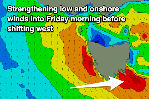
The broad, multi-centred low linked to the current cold and wet weather will strengthen during tomorrow and it now looks to sit right over us for the coming days, bringing onshore winds and some chunky, localised windswell.
 Tomorrow will be average with a moderate SW'ly, strengthening from the S'th into the afternoon as the low strengthens and this will spoil an inconsistent mix of W'ly groundswell and mid-period energy. 2ft+ sets are due across Clifton but with that onshore wind and choppy conditions into the afternoon.
Friday will be a mess with strong S/SE-SE winds feeding into the low along with a junky windswell in the 3-4t range.
We're expected to see the low shift to the west through the day, allowing winds to ease and tend lighter E'ly into the afternoon, though the surf will still be lumpy and scrappy. Keep an eye on things later for a window.
The low is expected to shift back to the east on Saturday with a return to onshore S/SW-SW winds but with the S/SE swell fading overnight Friday, leaving no swell with any size or power.
We may see weak 1-2ft waves but with those onshore winds.
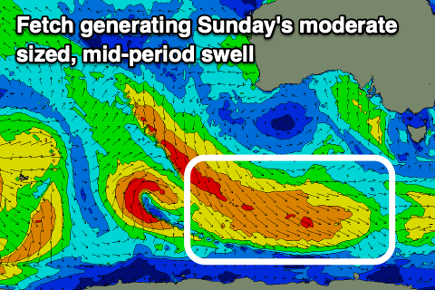 Come Sunday we've got a new mid-period SW swell due, generated by a healthy polar fetch of strong to gale-force W/NW winds pushing in through our swell window over the coming days.
This should provide good 2ft+ sets, though spoilt by persistent SW winds on the backside of the low as it pushes further east.
Conditions should finally clean up on Monday with N/NW tending variable winds but easing 1-2ft surf.
Longer term there’s nothing too major at all for next week as a slow moving, blocking high pushes in across the south of the country, but we'll have a closer look at this Friday.
Comments
The low has shifted west and winds have gone offshore..
Wow and 79mm to 9am in Hobart.