Nice groundswell to finish the week, then a windy weekend

South Arm Surf Forecast by Ben Matson (issued Wednesday 21st October)
Best Days: Thurs/Fri: inconsistent but fun new long period groundswell with light winds. Sat/Sun: plenty of swell but generally bumpy and onshore.
Recap: Building long period groundswells increased from 2ft to 3ft+ through Tuesday, before easing slowly today. Conditions have been clean with light winds.
This week (Oct 22 - 23)
*This week’s Forecaster Notes will be a little erratic as Craig’s on annual leave*
The next swell is on the way. I’m anticipating the leading edge to reach the Cape Sorell buoy tonight - probably the early hours of Thursday morning - so the early session on Thursday will probably start out undersized, with leftover energy from today. But, a steady increase will occur through the day and by late afternoon we should be seeing plenty of new energy across the region.
Expect small conditions early on in the 2ft range, building to 3-4ft into Thursday afternoon. However, set waves will be very inconsistent at times, and I'm a little suss on the swell direction - models suggest SW but the storm track was a little further north than ideal, which may bring about more of a W'ly direction across Southern Tasmania and this may have an adverse affect on size and consistency.
Nevetheless, we will see some fun waves across the region, and conditions should be clean all day with light variable winds. Size will then ease into Friday with similar winds across the region.
This weekend (Oct 24 - 25)
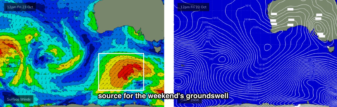
We’ve actually got a decent groundswell on the way for the weekend, courtesy of a nice cycle of polar lows below the continent from tonight through into Saturday (see below). This is a very good region of our swell window, as the more eastern storm track results in a little more S/SW in the direction, which allows the energy to get into the South Arm more efficiently.
However, there is a risk of onshore winds both days - especially on Sunday - as the associated fronts clip the coast. Early morning will see the best chance for a window of lighter W/NW winds but it’ll probably swing W/SW at moderate to fresh strength by mid-late morning, holding into the afternoon. Winds will then veer S’ly into Sunday as the system moves further to the east.
As for size, the more eastern position of the storm track suggests a little more size than from a typical front, so we should pick up occasional 4ft sets by late Saturday (smaller earlier), holding into Sunday morning. However, it may be a little undersized for the sheltered points.
Next week (Oct 26 onwards)
A high pressure system will dominate our weather early next week, with E’ly winds developing around Tuesday, tending NE into Thursday.
A synoptic blocking pattern is expected to develop upstream this weekend, and this will essentially shut off the swell supply to the South Arm for a few days. So, expect very little in the surf department throughout this period (early Monday may see a few small waves, leftover from Sunday, and it’ll be clean with light winds).
Fortunately, there are some interesting developments for the long term.
An amplifying Long Wave Trough well west of WA next week will slowly migrate eastwards. Small long period forerunners from the Indian Ocean activity will grace out coastline from Thursday onwards, though no major size is expected through into the weekend at this stage. However as the storm track shifts more favourably into our swell window later next week, we’ll start to see size prospects increase for the following week.
More on this in Friday’s update.