Small conditions to persist for some time; solid and windy next week

South Arm Surf Forecast by Ben Matson (issued Tuesday 19th March)
Best Days: No great days at this stage.
This week (Mar 20 - 22)
Today’s Forecaster Notes are brought to you by Rip Curl
*this week's Forecaster Notes will be occasionally brief and erratic, as Craig is on annual leave - they’ll be updated Tues/Thurs/Sun - to receive notification when they’re updated, please update your account preferences*
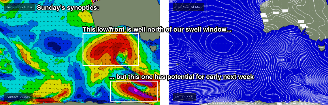
We’re in the midst of a regional blocking pattern with the main influence for our region being a stationary belt of high pressure across the Southern Ocean, stretching from underneath Western Australia through South Australia to a position below Tasmania.
In addition to delivering mainly light winds across the state, the block is forcing Southern Ocean weather systems away from our near swell window, which is reducing the size and strength of inbound swell events for the short term - most of the energy we’re seeing at the moment is sourced from polar lows/fronts travelling through our far swell window(s) over the last few days.
A continuation of this pattern is expected for the rest of the week, with mainly small residual swells and light winds on offer.
A new swell is expected to reach the region on Friday but the storm track associated with the source fetch is a little too north in latitude to favour the South Arm, so we’re looking at only small surf to finish the working week; a slight kick is possible late in the day but I’d be surprised it it pushed north of 2ft.
This weekend (Mat 23 - 24)
The regional block is expected to break down later this week, and will result in a frontal passage over the state this weekend. We’ll see strengthening N’ly winds on Saturday veer W’ly into Sunday at strength.
However, the storm track will still be positioned out of our swell window at this time so it’s unlikely we’ll see any new swell for the weekend.
Friday’s late pulse should hold into Saturday morning but we’re unlikely to see much more than a stray 2ft set early in the day easing to 1ft into the afternoon, and remaining at this level into Sunday.
Next week (Mar 25 onwards)
A much more vigorous weather progression will cross the Tasmanian region early next week, as a series of complex lows moves across our longitudes (see below). It’s still early days, but current indications are for small windy conditions Monday ahead of solid mix of SW swells on Tuesday and Wednesday with gusty winds from the W thru’ SW. Strong secondary swells are possible behind this too.
Let’s take a closer look in Thursday’s update.