Large swells inbound with varying winds

Southern Tasmania Surf Forecast by Craig Brokensha (issued Wednesday 6th March)
Best Days: Thursday, selected spots Saturday morning, Sunday morning beginners, next Wednesday
Recap
Tiny surf yesterday, but our strong new W/SW groundswell for today has come in nicely with clean 2-3ft sets across Clifton but limited surfing options.
Today’s Forecaster Notes are brought to you by Rip Curl
This week and weekend (Mar 7 - 10)
Today's swell will ease off through tomorrow, but there should still be fun 2ft+ sets on offer through the morning with a NW offshore, only tending W/NW later in the day.
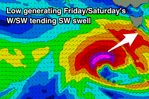 Friday morning will start tiny, but a strong and deep low forming west of us tomorrow will generate a fetch of severe-gale to storm-force W/SW winds through our western and then south-western swell window while tracking quickly east.
A large though short-lived W/SW tending SW groundswell should be seen, building to 2-3ft later Friday with onshore SW winds as the storm passes south of us, easing from 3ft+ Saturday morning, down to 2ft into the afternoon and 1-1.5ft Sunday morning.
Winds Saturday are funky with a light E/NE breeze due through the morning, giving into SE sea breezes, so surfing options will be limited.
Sunday will be cleaner with a N/NW offshore but tiny easing swell.
As touched on last update, a strong node of the Long Wave Trough will develop across the south-east of the country early next week, and with this we'll see a significant storm steered up towards SA and Victoria but through our western swell window.
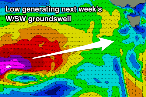 A fetch of storm-force W/SW winds will be projected through our western swell window, with the storm weakening and moving more into our south-western swell window Monday evening and Tuesday.
We should see a large long-period W/SW groundswell generated, building late Tuesday and reaching 3-4ft by dark, easing from a similar size Wednesday morning.
Winds Tuesday look onshore, but Wednesday should offer cleaner conditions with a W/NW offshore. We'll confirm the size, timing and local winds surrounding this swell on Friday.