No significant swell until next week

Southern Tasmania Surf Forecast by Craig Brokensha (issued Wednesday 5th September)
Best Days: Beginners late Friday and early Saturday, Monday afternoon and Tuesday morning
Recap
Good easing 2-3ft sets on the coast yesterday morning with a mix of new W/SW and easing S/SW swell.
This morning it's back to a tiny 1-1.5ft and better at more exposed spots with the northerly breezes.
Today’s Forecaster Notes are brought to you by Rip Curl
This week and weekend (Sep 6 - 9)
I hope you made the most of the last few days of waves, as we've got a slow period ahead with nothing of significance until next week.
We're looking at tiny surf tomorrow with N/NE winds, while a very minimal increase in W/SW swell may be see on dark Friday from a small fetch of W/SW winds around a low tomorrow.
We're talking 1ft+ on dark, easing from a similar size Saturday providing waves for beginners.
Winds will be favourable and W/NW later Friday and N/NW Saturday.
Our new W/SW swell from a strong but distant polar front later Sunday has been downgraded with the front now due to be weaker.
 With this only a very slight increase in swell may be seen on dark, with inconsistent 1ft+ waves due.
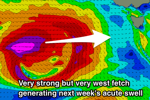
A much stronger but northerly placed front will aim a great fetch of severe-gale to storm-force W'ly winds through our western swell window, dipping south-east and away from us on approach Sunday.
An acute long-period W'ly groundswell is expected, filling in Monday and kicking to 2-3ft through the afternoon, easing Tuesday.
Winds look great and offshore from the W/NW tending NW Monday and N'th Tuesday, with the next increase in swell likely Wednesday from a mid-latitude front pushing across us. More on this Friday.