Fun swells over the coming days, strong clean swell Saturday

Southern Tasmania Surf Forecast by Craig Brokensha (issued Monday 9th July)
Best Days: Tuesday, Wednesday morning, Thursday morning, Saturday, dawn Sunday
Recap
It's great to be back after my sojourn around the Basque Country, if you get a chance it's more than worth a trip.
Saturday was tiny, but a strong front pushing up into us yesterday brought with it a stormy increase in swell, though kind of in between sizes.
This morning conditions were still poor as the swell dropped back to 3-4ft.
Today’s Forecaster Notes are brought to you by Rip Curl
This week and weekend (Jul 10 - 15)
Want to receive an email when these Forecaster Notes are updated? Then log in here and update your preferences.
We're looking at smaller waves into tomorrow but cleaner conditions as winds swing NW and hold most of the day.
Smaller easing surf from 2-3ft is expected, while into Wednesday morning a new reinforcing SW groundswell should keep fun waves hitting Clifton.
This was generated over the weekend by a short-lived polar low south of WA, aiming a fetch of gale to severe-gale W/NW winds through our swell window.
Sets to 2ft+ are expected but winds look to be the issue with a surface trough due to drift in from the south. We should see a period of NW winds most of the morning, shifting SE before midday. So don't sleep in too long.
 Thursday morning should see a return to offshore N/NW winds but small fading surf from 1-2ft.
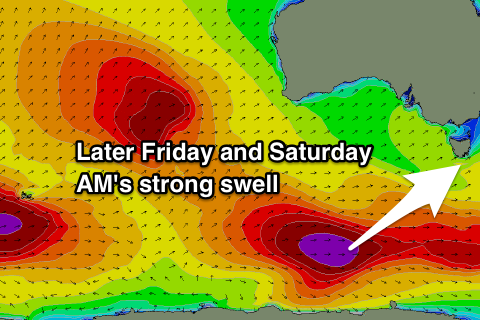
Moving into later Friday and Saturday morning, we've got a great new long-period SW groundswell expected across the region, generated by an intense and slow moving polar low that will form south-southwest of WA tomorrow morning.
The low will produce a stalled fetch of gale to severe-gale W/NW winds before pushing slowly east along the polar shelf through Wednesday and then slowly weakening Thursday south-west of us.
Friday morning will start tiny, but a strong pulse in size is due late to an easy 3ft but with a gusty S'ly change, with clean rapidly easing 3-4ft sets Saturday morning under a N/NW tending N'ly breeze.
Sunday will be clean but smaller and fading from 1ft to maybe 2ft.
Longer term there's nothing significant on the cards until mid-next week when the Southern Ocean starts to fire up to our west. More on this Wednesday.