Friday morning the best of the period

Southern Tasmania Forecast by Craig Brokensha (issued Monday 23rd June)
Best Days: Wednesday morning for keen surfers, late Thursday, Friday morning, early Saturday
Recap
The weekend saw pulses of small but fun S/SE groundswell either side of 1-2ft and exposed spots were the go to maximise the swell. Today we've seen the surf drop away back from a tiny 1-1.5ft and we'll see tiny waves continue until Thursday.
This week (Jun 23 - 27)
Give the surf a miss until later Thursday and more so Friday. We may see some small W/SW groundswell sneaking in Wednesday from a large swell hitting SA and Vicco tomorrow and Wednesday, but the winds generating this swell seem to be too north and out of our swell window.
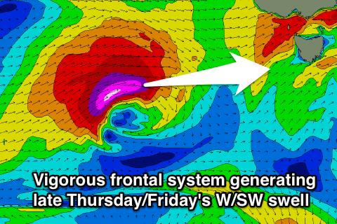 Into Thursday though a vigorous frontal system pushing in from the Bight is expected to aim a fetch of severe-gale W/SW winds through our swell window from early Wednesday morning right until it crosses the state Thursday afternoon.
A strong W/SW groundswell should result that's expected to build later Thursday to 3ft or so across Clifton before peaking Friday morning to 3-4ft.
Winds should be favourable and fresh to strong from the W/NW all day Thursday with excellent N/NW tending N'ly winds on Friday, opening up lots of options.
Get in early though as the swell will drop steadily through the day.
This weekend onwards (Jun 28 onwards)
Friday's swell should continue to fade into Saturday from 1-2ft or so but into Sunday a mix of S/SW groundswell and S'ly windswell are due.
The groundswell will be linked with a weak but favourably aligned polar front firing up right below us on Friday while the windswell will be a result of another strong cold front pushing across us. Size wise there doesn't look to be much in it above 2ft on Sunday and winds look a little dicey and from the W/SW. We'll confirm this on Wednesday though.
Of greater importance is the movement of the storm track into a much more favourable position early next week. A strong node of the Long Wave Trough looks to move across the entrance of the Southern Tasman Sea, directing polar frontal activity up through our southern swell window. This might result in a strong S/SW groundswell Monday/Tuesday next week but we'll look at this again Wednesday.