Poor weekend, Monday morning the pick

Southern Tasmania Forecast (issued Friday 6th June)
Best Days: Monday
Recap
A new W/SW groundswell came in as expected yesterday with inconsistent 1-2ft waves across Clifton under all day offshores, while today the swell is slipping away from a tiny 1-1.5ft.
This weekend onwards (Jun 7 onwards)
There's nothing to get excited about this weekend as a cold front pushing across the state brings with it a fresh to strong onshore change just after dawn, creating poor conditions and kicking up a low quality windswell to 1-2ft or so.
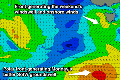 The windswell will drop through Sunday in the wake of the change and winds look to linger from the S/SW, continuing to create average conditions.
Monday is looking a touch better as a small increase in S/SW groundswell arrives, generated by a polar front at the base of the system responsible for tomorrow's change.
This should provide a fun 2ft of swell Monday morning before easing into the afternoon and fading Tuesday. Winds should swing light offshore from the NW and then tend variable into the afternoon, creating a full day of clean conditions.
Longer term there's nothing major on the cards until next weekend when we should see some better W/SW and SW groundswell filling in. This will be related to a strong node of the Long Wave Trough pushing east from WA through the Bight, bringing some better polar frontal activity with it. Check back here on Monday for the expected size and timing of these swells, as the models are still a little divergent on the make up of the storm track.
In the meantime, have a great weekend!