Solid round of south swell, then a quality E'ly groundswell

South-east Queensland and Northern NSW Surf Forecast by Ben Matson (issued Wed 7th Dec)
Forecast Summary (tl;dr)
- Only small in SE Qld next couple of days
- Fun S'ly swell Thurs across Northern NSW, though tricky winds (aim for an early session before the S'ly change pushes through).
- Bigger S'ly swell building Friday but wind affected
- Large S'ly swell building Sat/Sun across Northern NSW, much smaller in SE Qld, generally good winds most of Sat and early Sun
- Great E'ly groundswell later next week/weekend
Recap
Easing E'ly swell managed 3-4ft sets across exposed spots on Thursday with good winds for the open beaches. Wave heights eased through the day and further into this morning, though a new south swell is starting to fill in across the Mid North Coast this afternoon. Winds have been offshore early morning ahead of afternoon sea breezes from the NE. A brief, shallow S'ly change pushed across some regions overnight Thurs.
This week (Dec 8 - 9)
The current south swell pushing into Northern NSW reached a solid 4-5ft across Southern NSW today, which is bang on expectations so I'm not adjusting my outlook for Thursday - which is for stray 3-4ft sets at a handful of reliable south swell magnets south from Byron, easing through the day. It's a flukey, acute swell so expect much smaller at most other beaches, along with a small level of residual east swell.
SE Qld will be very small for the most part, just a foot or two of leftover energy at the regional swell magnets.
The main issue on Thursday will be the local winds.
We've got an approaching southerly change that's due mid-late morning on the MNC, and then mid-late arvo on the Northern Rivers, before it peters out (as mentioned Monday, the wind may swing earlier, but the bulk wind strength isn't really due for a few hours behind this).
Ahead of the change, we'll be at risk of fresh northerly winds though the gradient flow won't be terribly broad so I'm hopeful for pockets of NW winds at times.
Friday will see southerlies entrenched across the region though they won't be terrible strong and some regions may pick up early sou'westers.
The good news is that we've got a building southerly swell on the cards for the next three days, though the models aren't resolving it very well - expecting a similar size range from Friday thru' Sunday. I have a feeling Friday's model guidance is being overcalled, but the weekend is being undercalled.
Friday's surf will be generated by the trailing fetch behind Thursday's change, which won't be very well consolidated and not particularly strong either. Couple that in with a predominant southerly airstream and we're looking at wobbly 3-4ft+ waves at select south swell magnets south of Byron, but much smaler surf elsewhere, and very small surf throughout SE Qld - mainly locally generated from an adjacent S/SE fetch of short length associated with a developing ridge across the southern Qld coast.
So, keep your expectations pegged a little lower than normal for Friday.
This weekend (Dec 10 - 11)
On Thursday and Friday, a new Tasman Low will develop off the Southern NSW Coast and move slowly eastwards. The latest model runs have strengthened this low, broadened its fetch and slowed its eastwards track.
Which means bigger surf for the East Coast, though generally favouring Southern NSW.
The main energy wull push through the Mid North Coast on Saturday morning, reaching the Northern Rivers by the early afternoon, holding into Sunday morning before trending down through the day.
Keeping in mind the delayed arrival in the north and an earlier arrival in the south, we're looking at a peak with solid 5-6ft+ sets at south facing beaches south of Byron, and good options at semi-protected locations under a generally light variable airstream.
SE Qld will see much less size, though exposed northern ends shoud pick up 3ft+ sets at times, however we will be under the influence of the a weak local ridge which will steer winds to the SE. Early morning should offer small windows of SW winds, mainly across the southern Gold Coast (a little less likely on the Sunshine Coast). Either way, expect only small surf at the semi-exposed Qld points as the swell direction will simply be too south to benefit these spots to any major degree.
Surf size will slowly taper off through Sunday, though should still be pretty chunk at first light at south swell magnets. Wave heights should lose a couple of feet at least through the afternoon.
Early light winds will give way to freshening NE breezes in the afternoon that may become quite gusty across the Mid North Coast. So, aim for an early session.
And again, it'll be much smaller throughout SE Qld. You'll have to hit up exposed northern ends in the early morning for the biggest and best waves on Sunday.
Next week (Dec 12 onwards)
Early next week should see some peaky NE windswell from the local source developing through Sunday afternoon, though we'll need to identify the specifics of a W'ly wind change associated with an approaching low from the south-west. The timing on this isn't clear but I'll have a better idea in Friday's notes. Either way, small peaky beachies are on the menu right now for Monday or Tuesday in tandem with easing S'ly swell from the weekend.
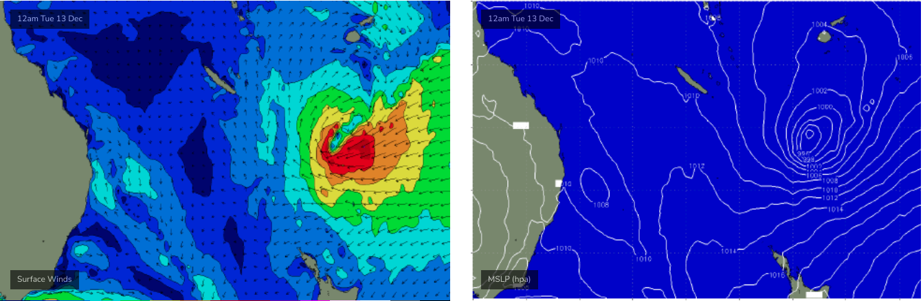
Elsewhere, and the good news is that the long range models are suggesting a deepening tropical low near Fiji from this weekend onwards (see below) - plus a strong supporting ridge and associated trade flow to its south-east - that's expected to generate a cracking E'ly groundswell for the end of next week and the following weekend. Possibly up into the 4-6ft range across some exposed spots, though it's early days right now and I'm feeling a little perky (I mean, have a look at the synoptic chart below! If that eventuates, we'll see a little more size).
See you Friday!
Comments
TASTY
4 - 6ft the ski hero’s better tune up their engines and camera skills.
Maybe Thor and Mark Mathews can bring a proper film crew and edit out the paddle surfers next time
These swell pulses lately are coinciding with the weekend. Brizzos will be loving it .
Northerlies have been gusting 25kts at Cooly since 10am, but Cape Byron's NE gusting 15kt. Normally 'tis the other way around.
The S'ly got into Port Mac around 11am but hasn't reached Coffs yet.
Wasn't much south swell on the Tweed this morning either.
Looks like EC and GFS coming into alignment for the earlier parts of development of this tropical low. GFS still slightly more bullish long term with the fetch stretching out just above NZ north island mid next week.
EC seems to have the better forecast track for our swell window.