Think the charts look devoid of activity? Have another look...

South-east Queensland and Northern NSW Surf Forecast by Ben Matson (issued Monday 22nd July)
Best Days: Tricky outlook overall - but aside from a small SE swell Tuesday (mainly Northern NSW) there is good E'ly swell potential from Wednesday onwards, with the weekend possibly becoming quite sizeable throughout SE Qld with a long period E'ly swell event.
Recap: The weekend delivered super fun waves across Northern NSW around 3-5ft, easing to 3ft+ on Sunday and still managing a few stray 2ft+ sets this morning. Surf size was significantly smaller across SE Qld due to the southerly swell direction, with only south facing beaches really offering anything worthwhile.
This week (July 23 - 26)
Today’s Forecaster Notes are brought to you by Rip Curl
By and large, the swell charts look devoid of activity at the moment, with an amplifying node of the Long Wave Trough over WA and SA steering cold fronts to the south, away from our region.
However, we have a few unusual swell sources to keep a watch out for.
As Craig mentioned on Friday, a small SE swell will filter through on Tuesday, thanks to a brief fetch of poorly aligned S’ly winds off the SW tip of New Zealand yesterday. The models aren’t picking up this swell very well, but I still think there’s a chance for inconsistent 2-3ft sets across exposed beaches (mainly south facing) south of Byron on Tuesday, though it’ll be tiny across SE Qld (just a few stray 2ft sets across exposed northern ends and south facing beaches).
It’s not a swell event to work around as the sets will be slow, flukey and inconistent, but fortunately it’ll be clean with light winds through the morning. There may also be a slight delay in the Far North and into SE Qld early morning. Keep an eye out for a possible N’ly breeze after lunch too.
The only other local swell source this week is a modest front pushing through eastern Bass Strait overnight Tuesday and into the early hours of Wednesday morning. We’ll see a late increase in building S’ly swell across the Mid North Coast, but Thursday morning should see a peak in size from this source, around 3ft at south facing beaches south of Byron, much smaller elsewhere, and unlikely to offer anything worthwhile through SE Qld. Conditions should be OK with light winds though lingering S/SW breezes are possible about some coasts.
This swell will then ease slowly into Friday, again favouring south facing beaches south of Byron Bay.
Now, while this is going on, a much more significant sub tropical low pressure system will have been spinning off the NE coast of New Zealand (see below).
It’s an absolute doozy.. but.. it’s sitting mainly inside New Zealand’s swell shadow.
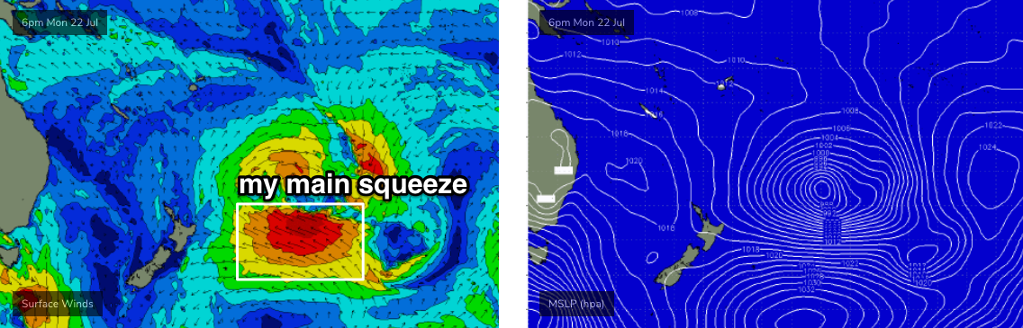
The most impressive feature is its slow eastwards trajectory, whilst strengthening and broadening as it ridges up against a large high pressure system to the south. The resulting E’ly fetch will be broad, very strong and long lived - and had New Zealand not been in the way, we’d have been looking at an epic five day groundswell in the 5-6ft+ range, with a couple of days punching well above this figure.
Alas, most of the Australian East Coast will miss out on any major swell from this system. Your best chances for scoring good waves from this low are in SE Qld, especially around the Sunshine Coast region, which will experience less shadowing than everywhere else to the south.
The main swell energy is not due to arrive until the weekend, but prior to then we’ll see fluctuating E’ly swells build slowly from Tuesday (inconsistent 1-2ft sets), building a fraction more into Wednesday and again on Thursday - perhaps some 3ft+ sets - with Friday afternoon likely to punch a little higher again as successive pulses reach the coast.
However, it’s not a straightforward event, with a leading edge, upwards phase, peak and plateau then downwards phase. Instead, we’ll see intermittent, lully energy with long periods of flat conditions. These kidns of events are frustrating to predict and even harder to verify.
Additionally, anywhere south from (say) the Gold Coast can expect proportionally smaller surf than what’s mentioned above. The swell models are not handling this swell event particularly well, so confidence is not high - and with the regional wave buoys positioned only just off the coast, there won’t be much advance notice of the incoming energy so you’l have to monitor the surfcams like a hawk (we’ll provide more observational info in the comments below).
So, despite the otherwise unimpressive swell graphs, this week is certainly not one to write off, especially if you’re in SE Qld.
This weekend (July 27 - 28)
The E’ly swell is expected to hit full stride across SE Qld this weekend.
And I gotta say, it’s very hard to be totally confident on how much size we’ll see, because the primary fetch will remain right on the periphery of the swell window. Another couple of degrees to the south, and we could see almost no surf - another couple of degrees to the north and it’ll open up a much greater percentage of Northern NSW coastline for maximum surf size.
So, the best I can do is to estimate a possible peak in size for Saturday across SE Qld - again, more likely the Sunshine Coast than anywhere else - and expect smaller surf south from this point. Though local bathymetry will play a key role here (there’ve been plenty of similar synoptic charts in previous years, where we’ve seen bigger surf across the Mid North Coast than some parts of the Northern Rivers).
So.... in general, Saturday should see wave heights pushing a solid 4-5ft+ at exposed northern coasts, easing to 3-5ft on Sunday. We can expect the swell to be uncharacteristically strong - with swell periods north of 15-16 seconds - but it’ll be a little inconsistent at times (not as much as what you’d think though, due to the slow moving, long-lived synoptic pattern responsible).
Winds look generally light in the north (morning SW, afternoon SE) but we may see more strength across the Mid North Coast as a series of fronts push through the lower Tasman Sea.
Yes, it's a good weekend to be planning some water time. Let's take a closer look on Wednesday.
Next week (July 29 onwards)
Whatever the weekend delivers easterly swell-wise, we’ll see a gradual weakening through next week - though Monday should still be pushing 3-4ft+ at exposed beaches, and even Tuesday will only see a small drop in size and plenty of quality options. Model guidance keeps this impressive subtropical low active until the end of this week, which means we should see some form of easterly swell probably until next Thursday or Friday at least.
More on this in Wednesday’s update.
Comments
Ben, would you expect this E swell to behave similar to this swell below from July 2017...?
https://www.swellnet.com/reports/forecaster-notes/south-east-queensland-...
That was a slow 2-3ft 1 dayer (Fri 7th) so hopefully better!
Yeah, agree. We did a little better than that. 3-4 for a couple of days. But I remember how strange it acted. I’m a little north of Coffs, expected to be shielded from NZ and it was bigger in our area than the Sunny Coast and from memory they were predicting a decent swell up there..... bathymetry...... Hence why I asked if Ben had followed up on that strange outcome and whether his notes were going to reflect that, as the swell is being produced in a similar location. Sydney even generated E swell from the 2017 event.....
That sounds about right. Swell aimed directly at SC, actually twice as big south of the border.
Dear NZ, please GTFO of the way.
Regards
East Coast
Haha, I see that comment without fail every time there is a swell like that sitting behind New Zealand. I recall swellnet even did an article on why that would be a bad thing - because I think New Zealand helps the development of East coast lows?
Anyway, 15-16 second wave periods on this coast from the east is definitely something to look forward to. Wherever it hits, it will be worth a drive.
Your real problem is the entire Australian continent to the west of you. Get rid of most of that, leaving a thin strip of land and you'd have a west coast in easy reach. Similar to the far north of NZ as it happens.
15-16 period 3ft super inconsistent E swells are actually one of the hardest nuts to crack on this stretch of coast.
usually too long and straight for the beachies and barely worth it for the Points, unless you have some secret bank stashed somewhere.
Does NZ aid in the development of Tasman or ECL's? I'd say that's pure speculation.
Just for shits and giggles I tracked the swell window for South Brazil after the Rio comp , because I was was surprised how much swell they seemed to get. They had some substantial Atlantic lows with fetches aimed back at Brazil; similar to this current mid lat South Pacific low drifting polewards.
No doubt NZ blocks substantial amounts of quality E swell from these sources.
Very substantial
Though I doubt Enzed surfers see it that way
Anyone seen any signs of the longer period showing up?
Nothing yet. It's very early days, of which the next 72 hours are low confidence right across the coast. We'll post updates as obs start to show the new energy.
Small E'ly lines starting to show at Yamba.


And a few lines in Coffs too.


Swellnets Goldcoast report of "desperate stuff, but it's been that way for a while" sums it up well.