Back to back large southerly groundswells ahead

South-east Queensland and Northern NSW Surf Forecast by Ben Matson (issued Monday 21st February)
Best Days: Extended period of long period S'ly swells, biggest south of Byron, peaking Wednesday and then Friday a'noon though still solid either side. Much smaller across SE Qld.
Recap: No shortage of S’ly swell over the weekend, though the acute direction and long periods have resulted in a wide variation in size across the region. Saturday saw the most size up to 5-6ft across south swell magnets south of Byron Bay, easing to 3-4ft Sunday and holding in and around this size this morning before building to 4-5ft throughout the day (in fact, Hsig at the Crowdy Head buoy is now above 3m, which suggests much more size than that). SE Qld beaches have mainly see very small surf no more than a foot or two over the last three days, however exposed northern ends of the Gold and Sunshine Coast did pull in occasional 2-3ft sets late Saturday and occasionally at times on Sunday. Conditions have been clean with light winds.
Today’s Forecaster Notes are brought to you by Rip Curl
This week (May 22 - 25th)
We’re in the midst of a strong autumnal south swell pattern, with no signs of any let up in the near future. In fact it looks like we’re going to go up another gear or two as we progress into the end of the week and beyond, related to a slow moving node of the Long Wave Trough.
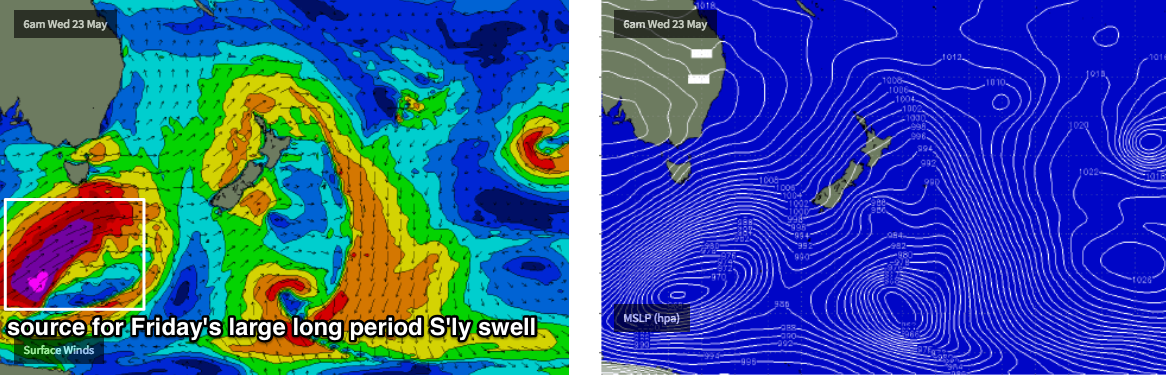
We’re staring down the barrel of back-to-back long period southerly groundswells, each offering varying levels of size, period and degrees of southerly direction.
By and large, because of this synoptic pattern, these Forecaster Notes are almost the same for Southern NSW as they are for Northern NSW, except for a few key points: (1) the higher northern latitude will result in a time lag by half to one day, (2) a slightly less favourably aligned fetch/swell direction (compared to Southern NSW) will result in an even wide range of maximum wave heights (3) a much reduced level of consistency, especially across SE Qld (where it’ll be a lot smaller than Northern NSW).
The only other notable point is that a brief ridge on Wednesday will freshen southerly winds across the region, accompanying the first large southerly groundswell throughout Northern NSW.
Tuesday should initially see continuing mid-range energy from today - most south facing beaches south of Byron are expected to hold out around 3-5ft though the anomalous size seen at Crowdy Head this evening - 3m+ Hsig and still trending up, with strong swell periods - would suggest another couple of feet on top of that. However most other buoys aren’t quite so strong so we’ll have to wait and see what the morning brings.
SE Qld will remain similar small as per today with tiny surf around the 1ft+ mark at most beaches, but keep an eye on exposed northern ends for a few sneaky 2-3ft sets. I wouldn't go hunting for 'em though.
Very late in the day (across the Mid North Coast) and into Wednesday (elsewhere) we’ll see the start of a series of step-ladder increases in height. This will be generated by a powerful front rounding the Tasmanian corner today, displaying very strong winds in excess of 40-45kts but more impressive is the length and fetch of the width, its relatively slow core forward speed (for a Southern Ocean front) and a slight meridional (north-south) tweak in its alignment through the lower Tasman Sea as we head into Tuesday.
Initially, south facing beaches south of Byron should see a building trend from the head of the fetch that’ll ratchet up wave heights into the 4-5ft+ range early morning, but this is by no means the strongest part of the system: Wednesday afternoon is looking at an almighty pulse of powerful long period southerly swell that’ll light up south swell magnets with very big surf in excess of 6-8ft+.
However, as mentioned above, southerly winds will freshen during the day and confine the best waves to sheltered points and southern corners, which will be smaller in size.
SE Qld’s outer points will fare well under this southerly wind regime but it’s difficult to have confidence in how much size we’ll see - the basic rule of thumb with south swells in Queensland is to halve your initial expectations, and then halve it again for good luck. But in all seriousness, south swells are very flukey north of the border, inconsistent and don’t often break well along the points compared to swells with a decent easterly component. More times often than not they disappoint rather than surprise with unexpected size. But for these notes we need a size anchor, and it’s likely that outer Gold Coast Points should see 3ft sets into the afternoon, a little smaller on the Sunshine Coast. Exposed northern ends will be bigger but more wind affected from the southerly.
And just on wave heights for all regions: with the associated long periods, it’s common to experience a wide variation in size from beach to beach, depending on exposure and bathymetry (as per Craig’s excellent article from last week Analysis: The long and the short of long period swells). But no matter how you slice it, Wednesday afternoon is looking pretty big and beefy south from Byron so even protected spots should have workable waves.
It doesn’t end there.
Thursday will see a steady drop in size from Wednesday, though still remaining elevated across south facing beaches south of Byron with sets around 6ft+, easing to 4-5ft throughout the day. A lingering southerly is likely across a few areas but in most regions we should be back around to light SW breezes. Expect smaller surf across the semi-exposed points and sheltered beaches.
SE Qld will also see smaller surf, easing from 2-3ft to 1-2ft across outer Gold Coast points, and a little smaller across the Sunshine Coast. Exposed northern ends could see 4ft+ surf and with lighter winds they’ll be more manageable.
Whilst this is happening, an even more powerful Southern Ocean low will have developed south of Tasmania, and is expected to slingshot through out far southern swell window, broadening and lengthening an impressive fetch of storm force SW winds through the southern Tasman Sea into Thursday morning.
If anything, this swell looks a little better on paper with stronger core winds, though it’s alignment isn’t quite as good as the fetch generating Wednesday’s swells. This will translate to larger swell periods but with slightly less ocean size at the coastal margin. This will probably in turn exaggerate the variation in wave heights across the coast even more from our mid-week event.
The new energy is expected to arrive throughout Friday, becoming largest into the afternoon. Those handful of offshore bombies and other reliable locations that accentuate long period south swells particularly well should be larger again - perhaps north of 8-10ft at times - but regular south facing beaches (south of Byron) will probably max out in the 6ft+ range, whilst everywhere else comes in much smaller. Across SE Qld we’ll probably see a peak around 3ft across outer Gold Coast points again, slightly smaller on the Sunshine Coast, but with very long waits between the bigger sets. Light to moderate SW tending SE winds are expected across all areas which will favour the points.
Again, I need to reiterate the fact that there'll be large discrepancies in wave heights from coast to coast. Despite being a stronger system, this swell won't be aimed as well for Northern NSW and so this time around, a smaller percentage of locations are likely to pick up the bulk energy.
This weekend (May 26 - 27)
Friday’s large southerly groundswell is expected to peak overnight and then ease slowly through Saturday though remain very solid across south facing beaches. Early sets should still be up in the 6ft+ range at south facing beaches south of Byron, but it’ll abate to 3-5ft throughout the day.
SE Qld will be half the size again, easing from 2-3ft at outer Gold Coast points Saturday morning (smaller on the Sunshine Coast). Light winds are expected to maintain clean conditions.
Into Sunday, yet another long period S’ly swell will grace the coast but this time ‘round it’ll be from a less favourably aligned system pushing through the south-eastern corner of the lower Tasman Sea (plus a little further south in latitude) so we’ll see smaller size than our last few long period swells.
That being said, it won’t be small by any measure - back up into the 4-6ft range at south facing beaches south of Byron into the afternoon (smaller earlier). SE Qld should see a small increase in size late in the day too, up to 2ft+ at outer Gold Coast points, smaller on the Sunshine Coast though bigger at exposed northern ends.
Also in the potential mix for Sunday across SE Qld beaches is a small short range SE swell originating from the tail end of a ridge stretching through the Coral Sea. No major size is expected though.
Let’s take a closer look in Wednesday’s notes.
Next week (May 28 onwards)
This entire progression of southerly swells - related to a slow moving node of the Long Wave Trough - will migrate to a position off New Zealand’s East Coast next week, whilst our Tasman swell window shuts down for a brief period. We may see some flukey long range SE swells from this LWT pattern but there’s nothing noteworthy on the long term charts at this stage.
Early next week may also see a continuation of small E’ly swell from the ridge in the Coral Sea but again, no major size is expected.
Comments
well pretty useless around these parts ...needs a good point break.
I was at two of northern NSW's most reliable south swell magnets this arvo........barely 3ft.
close to flat elsewhere.
no real new energy in the water close to dark.
I'd say that Crowdy buoy reading was an anomaly.
Swell pouring into Port on the cams later today.
Looks like that swell pulse hit just after dark according to Byron buoy data and periods have declined quickly through the wee hours. see what the morning brings.
at a certain world class point break NNSW it pumped 1/2 hour before dark. 3 guys out, highly blessed
Mmmm. That spot might be good on wednesday, depending on wind.
its all about sneaky long period pulses that most people brush off because they dont realise the gem on offer
Cheers for the great report Ben, and welcome back from hols. Looks like a full on week of swell if we get it.
Just before twilight swell started to rise with strong looking lines of swell appearing after checking it around 3:30, when there was nothing happening.
Lovely small empty peaks at D'Bah this morning.

Even a few lil' runners at Snapper too.

Felt like a few sets started to hit on dark around ballina 3-4ft, backed off at first light though, back to 2-3ft.
Was lucky to be 2ft at south magnet in yamba area today.
Ben do you think will get morning offshores on sunny coast . The night time temps don’t look to be getting that low at night which seems to be a bit of a caveat for morning offshore in the morning?
No sign of anything here this morning, small and weak.
This is pretty big for a non-south swell magnet in Coffs Harbour. Whitewater line is thick and chunky and the trail shows it breaking way off the headland (usually only when it's in the 6ft+ range). 'Twas a random capture by the surfcam too, so may not necessarily be indicative of the largest size either.

Hey Ben have to correct you about the above spot as it does catch a lot of swell from the south.
My point was that it's not the regional south swell magnet (so, other coasts that are even more exposed would be bigger).
But you are right, it does pick up south swells pretty well.
fcuking hell, that swell never showed up here.
Spoke to a bloke south of here and he said it was a soft 6ft.....it was 2-3ft here on dark and the arvo high tide buried that.