Stacks of short range E'ly swell ahead

South-east Queensland and Northern NSW Surf Forecast by Ben Matson (issued Monday 13th March)
Best Days: Wed: small building E'ly swells in SE Qld with pockets of OK winds, stronger swell on the Mid North Coast though more wind affected. Thurs: solid E/NE swell on the Mid North Coast with light winds, smaller surf in Far Northern NSW/SE Qld but also good conditions. Fri/Sat/Sun/Mon: building short range E'ly swells though onshore winds will develop over the weekend, confining the best surf to a handful of protected locations. Could become sizeable around Sunday.
Recap: Last week’s pumping E/SE tending SE groundswell held into Saturday but eased throughout the day. SE Qld saw perfect 3-4ft sets across the Gold Coast (see Snapper Rocks surfcam footagebelow), with slightly smaller surf across the Sunshine Coast, whilst Northern NSW pulled in solid 5-6ft sets ahead of the drop in size later that afternoon. Winds were light offshore in the morning with afternoon sea breezes. Sunday morning saw a further drop to 2-3ft and 3-4ft respectively as winds swung to the northern quadrant, but surf size eased more throughout the day. Today has delivered tiny conditions across all coasts with winds holding from the north.
This week (Mar 14th - 17th)
There’s nothing I love more than a stationary synoptic pattern. Slow moving weather systems - even small, weak patterns - always have their swell potential amplified and also result in a much more drawn out swell event, which increases the chances of finding favourable windows of opportunity.
And that’s what we’re looking at this week.
A slow moving trough of low pressure over the eastern states is expected to slow intensify over the coming days, assisted by a stationary high pressure system off New Zealand’s West Coast. Initially, this fetch will be focused into the Mid North Coast, and then Southern NSW, so there’ll be a range in mid-late week wave heights between the Mid North Coast (solid) and SE Qld (smaller).
Fortunately, the tail of the fetch will extend a reasonable a distance back into the northern Tasman Sea so we will certainly see a building trend across SE Qld at this time. And if you want to draw a positive against the smaller surf size (relative to the Mid North Coast) it’s that locations further north will see a higher chance of lighter, variable winds - and they’ll kick in earlier (sometime Wednesday, as opposed to Thursday everywhere else).
Anyway, the ridge will continue to concurrently develop further out to the east during the coming days, and later in the week it’ll realign into SE Qld’s swell window as a new high pressure system builds through the Tasman Sea. This will kick up a better swell potential for northern coasts this weekend.
Back to this week - the broad trend across Far Northern NSW and SE Qld will be slowly upwards, starting from a pretty small, weak base on Tuesday morning. By the afternoon we should see low quality 2ft+ sets across open beaches, then 2-3ft through Wednesday, 3ft through Thursday and 3-4ft into Friday.
If anything, expect wave heights to be slightly smaller on the Sunshine Coast.
Winds will be mainly onshore each and every day, but apart from Tuesday we should see pockets of light variable winds - becoming more prevalent from Wednesday afternoon into Thursday.
South of about Byron or Yamba, we’ll see an initial kick in short range E/NE swell through Tuesday afternoon and Wednesday, peaking Wednesday afternoon or early Thursday but accompanied by moderate to fresh onshore winds at times. These winds should become light and variable through Thursday and Friday as the trough moves slightly off the coast; Thursday morning is probably the pick with potentially 4-5ft+ surf in the south of this region, and good winds to boot.
So leave your surf until the second half of the week though keep in mind that wave heights will ease to background trade swell levels by Friday (3-4ft).
This weekend (Mar 18th - 19th)
The weekend outlook is quite dynamic for the region.
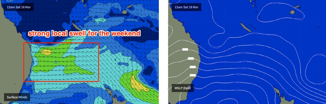
As high pressure builds across the Southern Tasman Sea, we’ll see a strengthening ridge across the Northern Tasman Sea. Of more interest are some modelled easterly dips between New Caledonia and the mainland, which are expected to retrograde westwards towards the mainland, enhancing wave heights from what’s likely to be a fully developed sea state.
This suggests building surf from 3-5ft on Saturday (SE Qld, Far Northern NSW) up to 5-6ft+ on Sunday if all goes to plan - though it’ll be accompanied with fresh E/SE winds. As such only protected locations will offer worthwhile conditions with open beaches and even some outer points likely to be blown out.
The swell trend from this pattern will be similar across the Mid North Coast, though smaller in size. Winds speeds may be a little lighter south of about Yamba but it’ll still hold from the eastern quadrant.
So, there’s plenty of waves in store for the weekend but clean options are likely to be limited to a handful of locations.
It is however worth pointing out that microscale systems embedded in the broad easterly flow can sometimes result in brief windows of favourable winds for various locations. These are impossible to forecast at long or even short range; it'll be a case of waiting patiently, watching the local obs and pouncing when they eventuate. More on this in Wednesday's notes.
Next week (Mar 20th onwards)
The first half of next week is on track to continue the weekend’s easterly infeed across the coast, driving gusty onshore winds, plenty of rain and solid surf to Far Northern NSW and SE Qld.
A gradual easing in all three parameters is likely during this period however we will need a few more days to firm things up, as this system is currently modelled to be right on our doorstep and therefore small movements in its position could have a dramatically different outcome.
Also of interest is a modelled system just NE of New Zealand later this week that’s expected to energy from the swell shadow and could be a source of small long range E’ly swell through the middle of next week for locations north of about Coffs Harbour. Ballpark size range about 3ft and very inconsistent, but useful if our local swell sources dry up quickly.
See you Wednesday!
Comments
Currumbin looking deceptively fun this afternoon!
Fun shoulder high sets at Dbah this afternoon. Winds seem to be SSE but it's not causing many problems here.
Thanks to all for fun appreciating surf this arvo. Hooting and laughing and sensible wave sharing. We do this for fun. Mantra.
Dbah looks fun ...whys that guy got a steamer on ?
Asian I suspect. Tend to feel the cold a bit more or so I'm told.
The rain is hammering down on the Tweed Coast in biblical proporations this morning. Haven't seen it like this in ages!
According to the BOM, Goonengerry (just west of Byron) has picked up 161mm in the last 3 hours.
Currumbin ain't looking too bad!