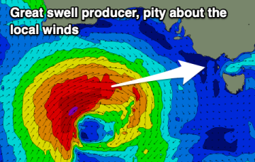
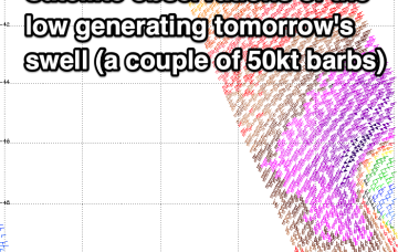
Good swell spoilt by south winds
A good quality swell for tomorrow with average though workable winds, cleaning up on the beaches later week but with no swell.
Another huge swathe of severe gales pushing of Japan Tues/Wed tracks towards Hawaii with a captured fetch , generating another large/XL swell Fri with size pushing up into the 15ft range, with light SE winds expected as the edge of the windfield sweeps past the island and a weak high pressure ridge builds in behind it.
A poor outlook with average winds when the swell finally comes up. Maybe head to the cricket instead.
The slowed movement and enlargement of the wind field as it approaches the North Island are on track to deliver more powerful long period E-E/NE swell, not ideally aimed for Tasmania but with enough strength to deliver some 3-4ft sets through Mon and Tues.
The slowed movement and enlargement of the wind field as it approaches the North Island are on track to deliver more powerful long period E-E/SE swell, right on the edge of the Southern CQ swell window.
There's been an upgrade in one of the storms generating Sunday's reinforcing swells.
The low (Ex TC Cody) is drifting slowly south-southeastwards towards the North Island with an extensive swath of storm force (50knot) winds along the south-western flank. These storm forces winds are embedded in an expansive gale force wind field.
The incoming swell looks to be initially a little more west in nature which is a plus.
TC Cody is the main game in town and the system has now undergone extra-tropical transition and is classified as a storm force sub-tropical low.
We've got an average run of winds and conditions, spoiling a good quality groundswell next week.