Fun waves for the gulf early next week

South Australian Surf Forecast by Craig Brokensha (issued Friday January 14th)
Best Days: Late Monday on the Mid Coast, Tuesday and Wednesday morning on the Mid Coast
Features of the Forecast (tl;dr)
- Tiny, mid-period W/SW swell buiding later Sun, peaking Mon with S/SE winds
- New W/SW groundswell building late Mon, peaking Tue with fresh SE tending strong S/SE winds
- Easing SW groundswell Wed with fresh SE tending strong S/SE winds
- Easing mix of SW and S/SE windswells Thu with moderate E/SE tending fresh S/SE winds
Recap
A shift in winds to the W/NW yesterday morning down South with a tiny 1-1.5ft of leftover S'ly windswell, similar this morning but even smaller. The Mid Coast has been tiny and wind affected.
This weekend and next week (Jan 15 - 21)
The coming weekend doesn't look to offer anything in the way of surf with the swell bottoming out into tomorrow and Sunday morning. Winds will be light out of the S/SW on Saturday, shifting S through the day and then around to the E/NE on Sunday morning but it's all academic.
The Mid Coast should see a tiny, mid-period W/SW swell arriving late on Sunday, peaking Monday to 1ft, generated by a relatively weak mid-latitude front pushing up towards Western Australia the last couple of days. S/SE winds will create favourable conditions across the Mid Coast on Monday for beginners.
Of greater importance is the moderate to large W/SW-SW groundswell due into Tuesday.
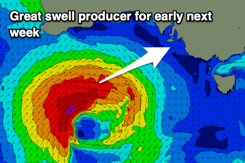 The low linked to this swell is currently developing south-west of Western Australia and now looks to move more favourably through the Mid Coast's swell window initially before moving through our south-western swell window.
A great fetch of gale to severe-gale W/SW winds are forecast and this should generate a moderate to large groundswell that will likely be seen later Monday but peak Tuesday.
The Mid Coast may reach 1-2ft by dark but Tuesday looks to offer 2-3ft sets on the favourable parts of the tide with 4-6ft waves across Middleton. Winds will unfortunately be gusty from the SE tending stronger S/SE, favouring the Mid Coast with similar winds on Wednesday as the swell eases. There'll also be moderate levels of S/SE windswell in the mix on Tuesday afternoon and Wednesday, easing through Thursday as winds shift lighter E/SE through the morning.
Unfortunately by the time winds shift E/NE-NE on Friday morning there'll be no groundswell left in the mix with fading levels of S/SE windswell.
Longer term the outlook goes quiet again so try and make the most of the swell from later Monday through Wednesday. Have a great weekend!