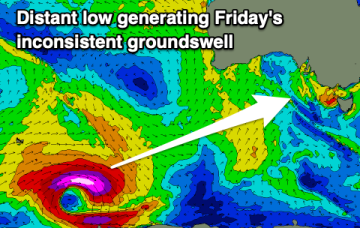
Good surf tomorrow, tricky weekend
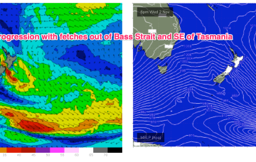
A fun new swell with offshore winds is due tomorrow, poor Friday but then improving on the weekend with a new swell for Saturday morning.
We’re in the middle of a winter-style pattern more common in August than November with a small low formed in along a front/trough line off the Gippsland Coast accelerating W’ly winds across most of the Eastern seaboard. A series of deeper fronts and lows are also transiting the lower Tasman as part of this cold outbreak. While they are not ideally positioned for maximal S swell production up the East Coast we are still looking at some useful S swell pulses over the rest of the week and into the weekend.
Plenty of swell with favourable conditions developing from Friday around Victor Harbor, while the Mid Coast will fade and become tiny.
We've got a slight upgrade in the expected size over the coming periods and winds look generally favourable with options all over.
All the action is in the Southern states right now, with a deep dual-centred low pressure gyre backed up by a strong high moving in from the Indian Ocean generating a powerful fetch which is just behind Tasmania with respect to the S swell window.
There's no lack of swell inbound, with good windows for the savvy to work around wind wise.
Easing surf over the coming days ahead of some new SW groundswell energy through the end of the week. Slowly improving winds before going onshore Friday.
While we won’t get the full payload of S’ly swell from this system as the system gets shunted SW as it enters the swell window (NE would be ideal!) we’re still on track for a few usable S swell pulses this week mostly south of the border, with a trailing frontal system providing bigger S swell into and over the weekend.
There'll be no issue with swell over the coming period, though winds will spoil conditions until later week but more so the weekend.
While we won’t get the full payload of S’ly swell from this system as the system gets shunted SW as it enters the swell window (NE would be ideal!) we’re still on track for a few usable S swell pulses this week, with a trailing frontal system providing bigger S swell into and over the weekend.