Tons of swell with workable winds

Victorian Surf Forecast by Craig Brokensha (issued Wednesday 2nd November)
Best Days: Later today Surf Coast, tomorrow morning Surf Coast, Friday Surf Coast, Sunday morning all locations, Monday morning on the beaches, Tuesday on the beaches
Features of the Forecast (tl;dr)
- Moderate sized mid-period SW swell tomorrow through Sat, with a SW groundswell for Fri PM
- SW winds tomorrow, strengthening into the PM, but W/NW for a period in the AM on the Surf Coast
- Light-mod W/NW tending S winds on Fri
- Inconsistent, moderate sized + SW groundswell arriving later Sat, peaking Sun AM, then easing
- E/NE tending S/SE winds Sat, local offshore tending S/SE Sun
- Easing surf Mon with E/NE tending S/SE winds
- Smaller Tue with gusty N/NE winds
Recap
The swell increased out of the W/SW yesterday morning, cleanest on the Surf Coast with sets to 2-3ft, bigger but wind affected to the east. Into the late afternoon some new S/SW swell started to show but with choppy conditions under a strong W/SW breeze.
Today we've got a peak in S/SW swell along with lumpy but workable conditions on the Surf Coast, hitting 4ft+ on the sets across the magnets, with choppy 5ft+ waves to the east.
Winds will shift W/SW-SW through this morning but revert back to the W/NW later afternoon as a cold front approaches from the SW. This will create good waves for the late session with the S/SW energy holding a good size.
This week and weekend (Nov 3 - 6)
Today's S/SW swell energy is a mix of swell from a low that formed to the south of Tasmania, and fetch of SW winds at an oblique angle to our swell window, south of South Australia through Monday and Tuesday.
We can expect this energy to ease into tomorrow as some new, reinforcing mid-period SW swell fills in, holding Friday, then easing slowly later Saturday.
 There'll also be stronger pulses of groundswell for Friday afternoon in the mix, as well as our secondary, better pulse of swell for later Saturday and Sunday morning.
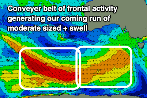
The progression as a whole has been upgraded slightly and we're looking at a conveyer belt of favourable wind activity, mostly strong and acting on top of an active sea state, but also followed by a great fetch of gale to severe-gale W/NW-NW winds swinging in on its tail.
The mid-period energy should come in at a good, consistent 4ft across the Surf Coast with 5-6ft sets to the east from tomorrow, while there's likely to be the odd bigger one on the magnets west of Melbourne.
The groundswell for later Saturday and Sunday morning, generated by the W/NW-NW fetch looks come more in the 4-5ft range on the Surf Coast magnets, 6ft+ to the east, then easing through the day Sunday, smaller Monday.
Winds are looking generally favourable but there'll be a couple of better windows to target over the coming days.
A late evening SW change today should revert back to the W/NW on the Surf Coast tomorrow morning (SW elsewhere), and with this there might still be a bit of leftover lump and wobble to conditions. Winds will swing back to the SW later morning and strengthen, creating average conditions into the afternoon.
Friday looks nice and clean with a light to moderate W/NW breeze, shifting S late morning but without much strength as a weak trough moves through the region. This should create workable waves through the afternoon, just a little bumpy.
As we move into the weekend, Saturday doesn't look to drop below 4ft on the Surf Coast and 5-6ft to the east, but winds will create tricky conditions, shifting E/NE ahead of S/SE sea breezes.
Sunday still looks favourable for both regions with light, local offshore winds (N/NW Surf Coast and N/NE on the peninsula and Phillip Island) before S/SE sea breezes kick in mid-afternoon.
Early to mid next week looks best for the beaches as the swell from the weekend eases and winds take a shift to the NE. More on this in Friday's update.
Comments
Amazing how this time next week the temperature will be double today!
Wonder if summer is gonna be dominated by those easterlies again. Good for water temp but not much else.
Wait for it Patrick, gotta see it to believe it.
Computer forecast is intriguing from Sat onwards. 8 day offshore/light winds and not dipping below 3ft. Believe it when I see it but that some sort record breaking shit.
We can live in hope.
Looks pretty solid this morning.
Was chunky, had heaps of fun.
Sorell still climbing, easy 6ft sets west from Melbourne.