Plenty of swell, cleanest on the weekend

South Australian Surf Forecast by Craig Brokensha (issued Monday October 17th)
Best Days: South Coast Friday morning, South Coast Saturday and Sunday, South Coast Monday
Features of the Forecast (tl;dr)
- Building mid-period SW swell tomorrow with strong SW winds (W/NW in Victor at dawn)
- Moderate sized + S/SW swell for Wed AM, easing a touch with strong SW tending W/SW winds
- Moderate sized mid-period S/SW swell Thu and Fri with S/SW winds Thu (S/SE in the AM on the Mid but tiny)
- Inconsistent SW groundswell for Fri PM with vairable E/NE tending S/SE winds
- Easing surf Sat with N/NE tending SE winds
- Inconsistent, moderate sized SW groundswell for Sun AM with N tending S/SE winds
Recap
Easing surf with choppy conditions on Saturday across the Mid Coast, cleaner Sunday but tiny.
The South Coast was cleaner with fun surf easing from 2-3ft, best in protected spots Saturday, cleaner Sunday but small and to 1-2ft.
Today the surf is at a low point and an approaching cold outbreak is bringing a W/SW change and cold, showery weather.
This week and weekend (Nov 1 - 6)
We've got a wintery few days of wind and weather ahead as a strong, slow moving cold outbreak pushes across us.
Swell wise, nothing overly significant is due owing to the frontal progression not having any major strength to it, but we'll still see surf up in that 4-5ft range at its peak owing to fetches of strong S/SW-SW winds projecting up and into us.
Looking at the evolution and today we're seeing strong SW winds directed through our south-western and western swell windows, with building mid-period W/SW energy due through tomorrow but with strong SW winds. At dawn in Victor a W/NW breeze is likely but it'll be brief.
Building mid-period surf to 2-3ft is due on the Mid Coast into the afternoon, 3-4ft down South but with those terrible winds.
S/SW swell energy will dominate Wednesday with easing sets from 4ft+ across the Middleton stretch along with strong SW winds, easing a little and tending more W/SW into the afternoon as a cold front clips the south-east of the country. The Mid will be onshore and easing from 2ft.
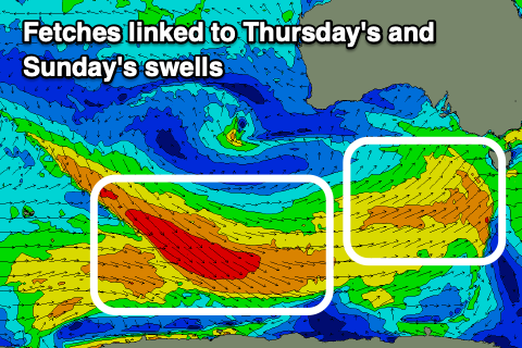
This front will be one of a couple, generating fetches of strong SW winds through our southern swell window, producing moderate pulses of S/SW swell from Thursday through Saturday.
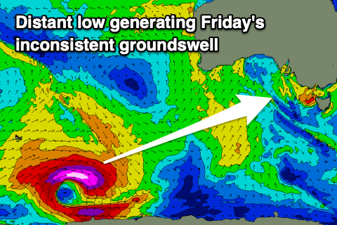 Also in the mix will be some inconsistent SW groundswell for Friday and Sunday morning, generated by firstly a strong polar low that developed east of the Heard Island region yesterday and second, a trailing fetch of NW gales sliding in behind it.
Size wise, the first pulses of mid-period S/SW swell for Thursday and Friday look to be 3-4ft across Middleton while the Mid Coast will be tiny and in the 1ft range.
The groundswell looks to be a similar size into Friday afternoon, with easing surf due on Saturday.
The secondary SW groundswell for Sunday looks to hold 3ft+ across Middleton, then easing into the afternoon and early next week.
 Winds are the main issue and look to be S/SW across the South Coast on Thursday in the wake of Wednesday's front, with a S/SE breeze across the Mid in the morning.
Lighter, more variable winds are due Friday morning, tending E/NE-NE through the morning ahead of SE sea breezes.
The weekend looks clean and fun with a N/NE offshore Saturday morning ahead of SE sea breezes, though not overly strong and N tending S/SE winds Sunday.
Longer term there's nothing too major on the cards but we'll have a closer look at this Wednesday.
Comments
Hi Craig, cheers for all the hard work at swellnet. There has been a crack in the screen on the knights cam for a couple of months now. Is there any chance of getting it repaired?
Hey Jasper, thanks mate! We'll be looking to replace and upgrade it in the next few weeks.