Strong south swells from Sunday onwards
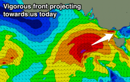
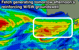
We’ve got a strong southerly swell due this weekend, originating from a vigorous front entering the lower Tasman Sea on Saturday morning.
Large stormy W/SW groundswell for tomorrow with limited options, clean and easing in protected spots on the Surf Coast Sunday. Smaller and clean again on the Surf Coast Monday, with a fun new swell Tuesday.
So, a couple of curveballs already this week. And it’s resulted in an upgrade for Thursday across Northern NSW (though only the morning).
Today’s south swell has me a little on edge.
Flat ahead of a small S'ly pulse Sunday morning and hopefully better increase early next week.
Easing W/SW swell tomorrow, tiny Friday, with some new onshore building SW swell Saturday, cleaner for a small window Sunday morning but smaller.
Western Australia Surf Forecast by Craig Brokensha (issued Wednesday 2nd Novemeber)
Best Days: Saturday as the swell builds before the sea breeze, possibly dawn Sunday, protected spots Monday, Tuesday morning
Recap
Tiny waves around Perth and Mandurah but clean conditions each morning, while swell magnets around Margs have been the best the last couple of days.
This week and weekend (Nov 3 - 6)
Mix of easing and reinforcing SW and W/SW swells tomorrow with offshore winds during the morning, easing Friday and clean through the morning. Solid swell building Saturday but with poor winds, better Sunday morning and best Monday.
Mix of easing and reinforcing W/SW groundswells tomorrow, cleanest on the Surf Coast, easing into Friday. A better window of clean conditions early Friday to the east. Large and stormy Saturday and then cleaner and great on the Surf Coast Sunday morning.
Large N/NW groundswell for Thursday and Friday across the North Shore, with an XL N/NW groundswell for Tuesday next week. E/NE-NE trade-swell for Micronesia and PNG from Friday.