Strong south swells from Sunday onwards

Sydney, Hunter and Illawarra Surf Forecast by Ben Matson (issued Friday 4th October)
Best Days: Sun, Mon, Tues: strong series of south swells with good winds early.
Recap: Thursday and Friday delivered another two days - making three consecutive, in total - of unexpected southerly swell across Southern NSW. Wave heights held in around the 3ft mark and conditions have been clean with light winds. Without going into much detail (as I’m going to spend some time over the weekend and early next week undertaking a comprehensive hindcast of this event), it appears that this series of south swells was sourced from an extremely remote and unusual part of our southern swell window. More on that early next week.
This weekend (Nov 5th - 6th)
We’ve got a strong southerly swell due this weekend, originating from a vigorous front entering the lower Tasman Sea on Saturday morning.
However, the timing is such that most of Saturday will see small leftovers from today (inconsistent 1-2ft south facing beaches, smaller elsewhere). The leading edge of this new swell should start to show across the South Coast during the middle of the afternoon, and may just reach the Sydney region very late in the day (slightly higher chance for the Illawarra coast, slightly lower chance for the Hunter coast).
Early NW winds will precede a brief S/SW change before lunch but winds should ease right back from the south into the afternoon. So conditions will be reasonably good throughout the latter part of the day however it’s hard to gauge how much size we’ll see - the most likely outcome is that Sydney’s south facing beaches will see late 2ft+ sets in the few hours before dark, but much more size is possible across the South Coast due to the swell reaching here earlier.
Sunday is therefore shaping up to deliver strong southerly swells, with south facing beaches seeing 4-5ft sets and the Hunter pulling in 6ft+ bombs. Conditions will be excellent with early light winds and afternoon sea breezes, however beaches not directly open to the south will be much smaller.
Next week (Nov 7th onwards)
The parent low to Saturday’s front will stall S/SE of Tasmania on Saturday, slingshotting a series of fronts through Bass Strait into Sunday (all contributing fresh south swell to our region) whilst also generating a secondary south swell off a S/SW fetch across its western flank.
This is expected to supply plenty of south swell across Southern NSW on Monday, probably of a similar size to Sunday however a little more consistency is expected as there’ll be two or three swell trains running concurrently. This may also create the odd bigger set at swell magnets.
Early morning winds should be very favourable, light out of the NW however they’ll freshen from the N and then NE during the day so make the most of the morning session.
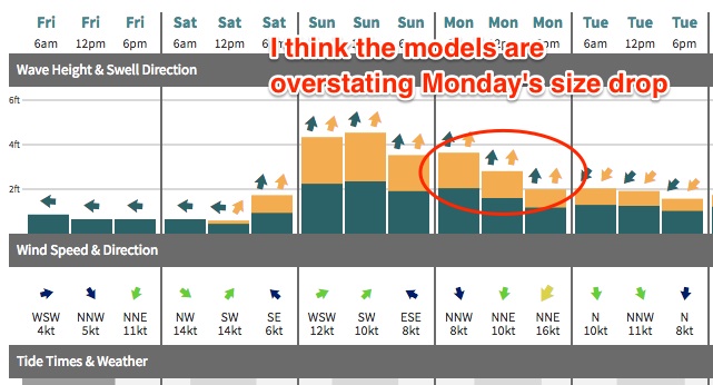
These southerly swells will then rapidly abate through Tuesday with freshening northerly winds ahead of a late southerly change across the South Coast. A small NE windswell is also possible across exposed NE facing beaches on Tuesday (from Monday’s freshening winds) however I’m doubtful we’ll see much size.
It looks like we’ll see a wind change across the Sydney region overnight Tuesday though no great strength is expected, and by Wednesday morning we’ll be back around to a light offshore breeze. Model guidance has a small S’ly swell trailing the overnight change though I think it’s overstating surf size at the moment, I’m not confident that there’ll be any major energy in the water on Wednesday. However south facing beaches should have some small weak waves in the 2ft range.
Looking further ahead and there’s nothing of any significant standing out in the long term forecast period at this stage.
Have a great weekend, and I’ll see you Monday!
Comments
Looks like that south swells arrived
Absolutely. It's doing it right now.
I just surfed a certain Northern Beaches point break that would usually be absolutely packed in such conditions but had a nice thin crowd this evening. Super consistent 4ft+ with very short periods (I counted about 7s between most waves). Jumped from near flat to pumping in about an hour.
Pancakecollaroy, I concur.
I checked the Port Botany buoy at 5:40, saw the kick in swell and headed straight to Freshy.
Expected a kick in size, but from 1-2ft to 4ft+ in an hour, not so!
It was amazing to be in the crowded ocean picking off super fun lefts to then see the size building set by set, cleaning out the crowds and pumping before it became too overpowering on the low tide.
Love this shit!
Here's the buoy readings, sitting on my computer when I left home and pushed the go button.

Little did I know the readings would jump so much! Ha!
Yeh paddled out in 1-2ft. Came in 4-5ft. Lots of fun!
definitely long waits along the NB stretch, bummer
Watched a couple of NB locations this morning.. sets were strong and clean but jeez it was pretty straight.
Swell totally missing at magnets down south, waist high low period grovel :(
Wow, really? And after many comments about how the forecasts have undercalled S swells on the South Coast.. seems very odd.
Yeah I know! Totally skunked! Maybe further north of Ulladulla pulled in the swell, but further south was almost flat.
the batemans bay buoy was a fair bit smaller than i thought itd be when i checked it around 10, we had reasonably strong south swell in illawarra, was quite fun. Ben, theres a few forecasts showing a short range NE swell in the water tomorrow, is this going to make things messy in the morning?
Yeh saturday lunch time was nearly flat between kiama and geroa then at 2pm it was waist high and by 3-4pm there was sets around double head high with odd bigger then by 7pm it was back to shoulder high.. swell was around the 10-11 sec period very clean and powerfull and consistant , winds were also strong west with 50 kmh gusts no worries definitely not a light sea breeze.. today tho it was only head high between kiama and geroa odd slightly larger sets. And much lower period maybe 8-9sec it looked like a wind swell, winds were light west till 8:30 before southetly started then veared sse by 11am i spoke to a mate in the durras region who said it was only waist high and slow down there and another frend reported solid double head high at Newcastle early this morning... definitely a little different then i anticipated compared to forcast today was a real disappointing but yesterday arvo was a extrem and welcom surprise
forecast notes still on track for tomorrow?
Sorry I haven't been able to comment much over the weekend, been out of range for the most part. Looking pretty good across the Sydney coast this morning as per the Bondi grab below.
Very interested in your updates for next weekend Ben.
Wasn't so much hope earlier, now hearing unreliable rumours of another south swell next Sunday, which I couldn't see getting here till Monday. Will go back to the charts and check for myself, but your learned comments required.
Yeah nothing our of the south until dark Sunday if that, more so Monday.
Spot on Craig.
New Forecaster Notes up now!
https://www.swellnet.com/reports/forecaster-notes/sydney-hunter-illawarr...
may as well called it flat south of batemans bay
It was small way down south? Wow that's bizarre. On the south coast there were some sizey sets coming through late afternoon sunday at the reef I paddled out at which doesn't even pick up southerly swell very well - mostly around 4ft but inconsistently 6ft+. The local guys I talked to in the water said the spot just around the corner open to south swell was 'pretty big and chunky, didn't feel like getting a flogging today'.
Early this morning still had some size around 4ft at the same reef and 3-4ft on the sets at an east facing beach, slowly dropping off and getting less consistent throughout the day.