Large stormy swell tomorrow, clean and easing Sunday

Victoria Forecast by Craig Brokensha (issued Friday 4th November)
Best Days: Surf Coast Sunday, Monday, Tuesday and Wednesday
Recap
Pumping waves on the Surf Coast all day yesterday again with a mix of W/SW swells and 3-4ft+ sets. Today the swell was on the ease from the 3ft range on the Surf Coast with offshores at all locations, while the Mornington Peninsula was clean and solid with 4-5ft sets.
Winds will swing NW and freshen through the morning ahead of a late W'ly change, so the Surf Coast will be best from late morning.
This weekend and next week (Nov 5 - 11)
Late tonights change is linked to a vigorous cold outbreak approaching from the west-southwest west.
This frontal system has been generating a tight fetch of gale to severe-gale W/SW winds, but this fetch will broaden and maintain its strength right until it pushes into us this evening in a 'captured fetch' motion.
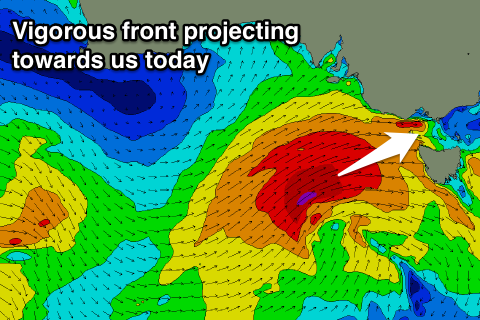 With this we'll see a large stormy W/SW swell for tomorrow, peaking during the late morning/middle of the day.
The Surf Coast will be a raw and choppy 6-8ft with 10ft+ waves on the Mornington Peninsula but with strong W/SW winds.
Into Sunday the swell will ease back steadily from the 4-5ft range on the Surf Coast (possibly the odd bomb at magnets early) and winds will tend back to the W/NW, persisting most of the day as another small front pushes in quickly from the west.
The strengthen of this front has been downgraded a touch, with the reinforcing swell due off it not really amounting to much.
With this we'll continue to see the surf easing Monday from 3ft on the Surf Coast and 4-5ft on the Mornington Peninsula.
Conditions will be best on the Surf Coast again with a N/NW tending NW breeze ahead of a late shallow change.
Into Tuesday a mix of very long-range and inconsistent long-period energy from a distant low off Madagascar earlier this week, and close-range mid-period W/SW swell is due.
The long-range energy probably won't be noticeable, but the close-range energy will be produced by a strengthening mid-latitude front approaching from the west on the weekend.
A healthy fetch of W/SW gales will be generated, with the swell peaking through the day at what looks to be 3ft to occasionally 4ft on the Surf Coast an 5-6ft on the Mornington Peninsula with westerly winds.
Beyond this easing surf is due, but more on this Monday. Have a great weekend!
Comments
Straight up WSW swell now? Not too much south anymore?
Was always forecast as W/SW Nick.
Geez when are these westerlies going to piss off. We have had 7 storms in October from the WSW and the average is 3. Shitful. Craig how strong are the WSW mean't to be on Saturday and is the swell more west than south?
Can you read ?
'large stormy W/SW swell for tomorrow'
'strong W/SW winds'
Sucks that Craig puts all the time to compile a good set of forecaster notes and still has to waste time repeating himself
Take a prozac and calm down. I know it is going to be blowy around 25+ kph I just thought Craig might have a bit more info'. Swell wise makes a big difference of how much south is in it as you should know coming from the west.
This is actually related to a strong negative AAO/SAM index.
When the SAM is negative, the polar westerlies are further north and closer to Australia, while when positive, the westerlies retract towards the pole.
Looking at 20-25kt W/SW winds, abating a bit through the day and yes swell more west than south.
Wow cool, does a positive AAO/SAM index indicate more SW fetches hence swells? Where is it taken, and how far in advance would the index be regarding wind and swell propagation ? Or is it just a real time measurement of the Antarctic pressure anomalies and not a forecasting tool.
You could expect more southerly swells if it's positive, but this also has to tie in with where the storm track is focussed etc. So it can all depend.
It's real time, there are forecasts though, but I don't think they're especially accurate.
Thanks Craig.
Lorne point looks pretty nice on the surfcam and swell seems to be still building if on,y the wind had co operated
winds werent that strong yesterday, amazing how a heading of the forecaster notes can affect crowds .... normally everyone sees westerly winds and crowds the winkis long lost brother but apparently there was only 5 out or so and winki was pumping with only a few. apparently two drowning at fishos ... ? condolences for the families
Shit thats full on torquooly condolences. Don't tell people that the forecast can be off sometimes mate just quietly enjoy.
South channel only recording 8 knots yet back beaches are white capping??
I thought they just fixed the thing
Winds were a fair bit stronger flinders/WP than bayside this arvo. Just one of those strange peninsula things, need a wind station oceanside. Or not
Nah we don't geek people can go for a drive get outside mate if they want to check the surf.
What he said.......
I was at the outside. At the beach. Just wondering why such difference. Soz yall
I've got it all sorted, I've secured funding from the goverment to employ an ex power plant worker as a butler/ chauffeur, I just send him down to check the surf for me.
Go outside and get a chill, really?
Must be an impressive bridge you live under Hako .
You know room for a Butlers quarters an all ! ;-)
Or does he just get the non waxed cardboard box !
You got it :-)