Flag the working week; the weekend is shaping up nicely

South-east Queensland and Northern NSW Surf Forecast by Ben Matson (issued Monday 5th December)
Sign up to Swellnet’s newsletter and receive the South-east Queensland and Northern NSW Forecaster Notes and latest news sent directly to your inbox. Upon signup you'll also enter the draw to win a surf trip to P-Pass for you and a mate. It doesn’t get much easier so click HERE to sign up now.
Best Days: Sat/Sun: small bumpy trade swell across SE Qld. Sat/Sun/Mon/Tues: plenty of south swell across Northern NSW, with OK winds in the mornings.
Recap: Small NE windswells and mainly fresh N’ly winds left very little to be desired across most coasts over the last few days. A small window of clean conditions was observed early Sunday morning - most likely due to Saturday’s intense thunderstorms pushing the synoptic northerly fetch off the coast (which also resulted in wave heights coming in a little smaller from this source). Nevertheless it’s been an extended period of unsurfable pain for SE Qld and Northern NSW surfers.
This week (Dec 6th - 9th)
The short term doesn’t look good.
Northerlies will persist on Tuesday, whipping up a small low quality windswell for the region.
Wednesday will see a reprieve from the northerlies as a shallow trough moves across the region, resulting in light winds tending some form of moderate southerly across Northern NSW throughout the day, possibly reaching the Gold Coast late in the day (unlikely for the Sunshine Coast though).
With no fetch behind the trough, we won’t see any swell from this source however Tuesday’s freshening northerly winds should kick up some small peaks for the Southern Gold Coast and Tweed Coast, and perhaps a handful of swell magnets around the Byron and Ballina region - maybe 1-2ft tops.
Elsewhere, surf size will remain tiny.
A small S’ly groundswell may also make its way up along the Northern NSW coast during Wednesday, though confidence is not high for any notable size or strength. An intense low tracking south of Tasmania looks good on the charts however it’s tracking to the south-east, perpendicular to our Great Circle path and is therefore unlikely to generate any meaningful surf to the region.
At best a couple of swell magnets may rake in occasional 1-2ft sets through the afternoon, but I wouldn’t get your hopes up.
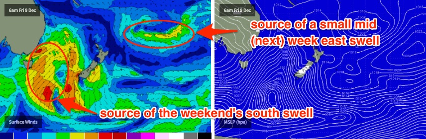
As for the second half of the week, the tropical system noted in Friday’s notes (N/NE of New Zealand) now looks like it’ll track to the east, which is generally unfavourable for swell production, given the enormous travel distance and overall modest fetch strength. It’ll eventually stall and probably align towards New Zealand’s North Island, but I’m doubtful that we’ll see any useful swell across the Australian mainland - maybe a small pulse mid-next week at best (see below).
Otherwise, early light winds and tiny residual swells on Thursday morning will precede a freshening northerly (again!) throughout the afternoon.
A front is expected to reach the Lower Mid North Coast early Friday morning, reaching Far Northern NSW through the afternoon. Ahead of the change winds will be NW, and we should see a building south swell in the lee of the change, probably 3-4ft across the Mid North Coast by late in the day but smaller across northern locations due to the later arrival of the change.
Ahead of the building trend from the south, the surf wil consist of tiny residual energy from the previous few days so we won’t have anything worthwhile at most beaches. Those beaches picking up the southerly increase throughout the afternoon will also be wind affected, so don’t expect anything great to finish the working week.
This weekend (Dec 10th - 11th)
The weekend looks OK across SE Qld, and reasonable across Northern NSW.
A ridge will develop across the Southern Qld coast overnight Friday, generating a short range SE swell that’ll build through Saturday and into Sunday morning. No major size is expected, and it’ll be biggest across the Sunshine Coast with bumpy sets around 3ft at exposed beaches, however winds will be fresh E/SE and the only locations offering protection from these winds will be very small indeed.
But, it’s better than the northerly garbage we’ve had of late.
Surf size from source will be little smaller across the Gold Coast (peaking around 2-3ft), but south swell magnets will pick up some additional southerly energy too. And there’s a chance for a period of early light SW winds across some parts of the Gold Coast before the sou'easters kick in.
Northern NSW will see progressively less synoptic trade wind as you head south - it’ll probably be confined to the region north of Ballina.
The parent low to Friday’s short range south swell will track east of Tasmanian longitudes, setting up a decent sized groundswell that’s expected to build Saturday and hold into early Sunday with sets around 3-5ft at south facing beaches, and smaller surf elsewhere.
Expect smaller surf at beaches not open to the south.
Surface conditions should be good both mornings (especially across the Mid North Coast) under light variable winds but sea breezes are likely each afternoon; Saturday from the south-east and Sunday from the north-east.
More on this in Wednesday’s update.
Next week (Dec 12th onwards)
A strong follow up front and low through the Lower Tasman Sea on Sunday will set up a stronger S’ly groundswell for Southern NSW, probably building late Monday across the Mid North Coast (Tuesday across Far Northern NSW), and possibly coming in a little higher than the weekend pulse.
This system looks much stronger but its alignment isn’t quite as good as the weekend’s fetches so hopefully it’ll maintain course as is (though it is at the end of the model runs so we can expect a few changes between now and then).
At this stage south facing beaches could see strong 4-6ft sets at south swell magnets south of Byron by late afternoon Monday or early Tuesday morning. Surf size will then throttle back through Tuesday afternoon and into Wednesday. Unfortunately, it looks like northerly winds will return during this period though we should see periods of early light nor'westers.
I’m not expecting this south swell to do much across SE Qld beaches away from south swell magnets. The weekend’s trade swell is expected to ease right back into Monday (as will Sunday's south swell in Northern NSW, for the early Monday session) however we should still see some small peaky beach breaks for the early session.
Also, just quickly - the tropical system in the South Pacific (mentioned above) will eventually line up in our far eastern swell window later this week and into the weekend but the large travell distance and ultimately modest fetch size and strengrh probably will restrict wave heights to a couple of inconsistent feet at best. An ETA for this is sometime mid-next week, and to be honest there'll probably be more important swells generated closer to the mainland by the time we get there (still, it's worth noting in case they all vanish from the existing model runs).
So, hang in there - we do have some swell on the way and it looks like the weekend will at least deliver a more pleasant round of lumpy surf compared to the northerly junk of recent weeks.
Comments
Gee, I picked an ordinary week for our holiday on the mid north Coast, after suffering through Sunny Coast conditions the last few months.
There's a few small lines out of the NE across Yamba this afternoon, and winds are NW here so it's clean. Elsewhere, it's fresh N'ly at Byron, and a mild S'ly change - much earlier than expected in yesterday's notes - has just gone through Coffs.
Coffs also picking up a few small NE lines though the southerly is ruffling the surface.
Hey Zen, I did some flathead tails in tempura tonight , deliciouso.
did some asparagus as well as some other vegies.
combined with a couple ice cold xxxx gold pale ales and a tiny hit of DMT.
very nice.
All time Steve.
"And a tiny hit of dmt"
On a Tuesday night fr76!
up, down and back again in 15 mins.
What is dmt ?
Sounds like a hell time regardless.
Edit : http://www.news.com.au/lifestyle/health/health-problems/dmt-is-becoming-...
Pretty big Tuesday night , alright.
Good on you.
What about the fear monger wankers at news corp with the above article - pick someone that had an anxiety attack whilst off chops then paint the whole drug as bad news.
Surprising they're not still working the " reefer madness " angle.