Solid south swell ahoy; chunky E/NE swell for next week

South-east Queensland and Northern NSW Surf Forecast by Ben Matson (issued Wednesday 16th October)
Sign up to Swellnet’s newsletter and receive the South-east Queensland and Northern NSW Forecaster Notes and latest news sent directly to your inbox. Upon sign up you'll also enter the draw to win a surf trip to P-Pass for you and a mate. It doesn’t get much easier so click HERE to sign up now.
Best Days: Thurs/Fri: building S'ly swell, showing strongest in Northern NSW, best early with light winds. Sat/Sun: building trade swell in SE Qld. Sun/Mon/Tues: small long period S'ly swell in Northern NSW. Mon/Tues/Wed: solid E/NE swell in SE Qld, a little smaller south of the border.
Recap: A strong south swell built across Northern NSW during Tuesday, with 5-6ft sets showing at some south facing beaches, though local winds rendered exposed spots very bumpy. Smaller surf was reported at remaining beaches, and wave heights remained tiny across SE Qld until the new south swell arrived, in which surf size essentially remained almost unchanged away from the region’s south swell magnets. Today we’ve seen easing size across Northern NSW (starting strong across the Far North), and south swell magnets across the Gold and Sunshine Coast saw early 2ft to almost 3ft sets ahead of the easing trend, though most SE Qld beaches and outer points remained tiny.
This week (Nov 17th - 18th)
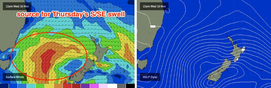
The next south swell is on the way.
There are a couple of positives and negatives associated with this next system but on the whole I think it’s going to deliver some very good waves.
The positives are that the responsible front is very broad and robust, travelling from polar latitudes through the central and eastern Tasman Sea, and wind strengths were reasonably strong within the core fetch. This should result in decent swell periods (Tp of 13-14 sec, Tsig of 10-11 sec), and the eastern position of the fetch should favour a slightly wider range of locations owing to a little more east (of south) in the swell direction.
However, the fetch wasn’t aimed very well through our swell window, which means the swell will glance the coast, resulting in less consistent set waves. And surf size won't be quite as big as if the fetch had been aimed up through our immediate south swell window. However a weak synoptic pattern is expected to accompany the swell’s march up the coast, so conditions will be clean.
The timing looks a little difficult to pin down. It looks like the leading edge will arrive across the Mid North Coast on Thursday morning - possibly not at dawn - before building towards an afternoon peak.
We’ll see this trend delayed across the Far North Coast (no major signs of an upwards trend until after lunch, showing strongest on dark) and exposed beaches in SE Qld - especially the Sunshine Coast - may not see any new energy until very late in the day, posisbly overnight.
A weakening ridge through the Coral Sea will result in moderate SW tending S’ly winds across SE Qld and Far Northern NSW on Thursday morning (no great biggie, as we’ll be between swells) and with some luck they’ll abate through the afternoon as the new energy starts to kick.
South swell magnets south of Byron should see late 4-6ft sets, with 3-5ft surf across the Tweed Coast on dark. Expect smaller surf at locations not completely open to the south, and also expect smaller residual energy early morning ahead of the new swell.
Reliable south swell magnets in SE Qld - if they do see this swell late Thursday - should pick up some 2-3ft+ sets right on dark (though, it’s a line call whether it’ll be worthwhile). Most other Gold and Sunshine Coast beaches probably won’t deliver much more than slow 1ft to maybe 1-2ft waves. Prior to the new swell these beaches will be tiny.
On Friday, this swell will ease steadily throughout the day, with an early dropping trend across the Mid North Coast (as the swell will be drying up from the south). The Ballina region (i.e. south from Byron to about Yamba) stands the greatest chance at seeing the most size across the entire region, with possibly 4-6ft sets at dawn though they’ll ease to 3-4ft by the afternoon, possibly earlier.
Expect smaller surf south of Yamba, and also across the Tweed, and especially so in SE Qld. South swell magnets across the Gold and Sunshine Coast should see 2-3ft sets before the easing trend kicks in but the open beaches and outer points are looking at 1-2ft surf early, smaller later.
Early light winds will freshen from the NE during the day so the early session should definitely be on your radar.
This weekend (Nov 19th - 20th)
The weekend forecast remains unchanged thus far. We can break it down into simple terms:
- Friday’s south swell will ease rapidly through Saturday and will probably new gone by lunchtime.
- A small, long period S’ly groundswell of unusual origins (S of Tasmania, Thurs/Fri) should provide inconsistent sets to 3ft on Sunday, probably in the afternoon, but only at south facing beaches south of Byron.
- A building trade swell related to a developing tropical depression in the northern Coral Sea should slowy increase E’ly swells across SE Qld from Saturday onwatds, reaching a peak late Sunday in the 3ft+ range across the Sunshine Coast, with 2-3ft+ surf across the Gold and Tweed Coasts and smaller surf with increasing southerly latitide.
Winds look like they’ll be mainly light to moderate onshore, with variable periods, probably throughout the mornings. Actual direction should be east across the northern regions and north across southern regions.
Next week (Nov 21st onwards)
The low responsible for Sunday’s groundswell (in Northern NSW) will travel only slowly through our far southern swell window, which suggests an extension of Sunday’s waves - whatever eventuates - into Monday, before easing slowly through Tuesday as smaller S/SE swells from the backside of the eastward traversing system makes landfall. If local winds play ball (currently expectations are light N’ly tending moderate NE), there could be some good waves across Northern NSW’s south swell magnets from this swell, especially with some additional energy in the mix from another direction (read on...).
I’m still keeping a close eye on a deepening tropical depression across the Coral Sea later this week and into the weekend. Model guidance has been strengthening and easing this system over the last few days, but it looks like we can apply a small upgrade to Monday’s notes, with wave heights likely to reach 4-6ft across exposed Sunshine Coast and possibly Gold Coast beaches, peaking some time around Tuesday before easing on Wednesday. So, Monday should see a steady increase from Sunday's size.
The actual spread of size will relate to whether the system maintains (or loses) intensity as it tracks closer to our region, but at the moment it’s more likely that the biggest waves will be found north of the border.
That doesn’t mean we won’t see good waves in Northern NSW. The current model guidance is now suggesting the axis of this system will push just south of Byron latitudes around Monday evening or Tuesday, which should favour a solid spread of E/NE thru’ NE swell throughout the first half of next week.
Local winds will be crucial to the prospects of the best waves; right now it seems that we’ll be under some kind of easterly influence until the trough axis drops south of Byron, after which time we’ll see S/SE winds freshen along the coastal margin.
In any case it’s looking like the first decent pre-season swell in quite some time for SE Qld, with great surf likely along the points, as long as the winds swing in our favour.
More on this in Friday’s update.
Comments
Nice to catch some waves with a bit of grunt today. Looking forward to next week too.
it was weird, I was on the rocks in the dark then surfed at dawn at an open beach, it was so pissweak ...then went back to the magnet mid-morning and it was pumping.
first surf in weeks thought all the sharks had split then this:
DPI Fisheries advise: tagged white shark detected by Sharpes Beach, Ballina receiver at 04:44:00 PM (AEDT) on 16-Nov-2016
0 replies 1 retweet 0 likes
NSW DPI advises that a dead whale has washed ashore at Broadwater Beach, Evans Head. Sharks are present in the wash zone
MIght be a bit more activity yet to come.
Ok, might stay away from SW for a little bit then.
Hi Ben, what are your thoughts on the winds for next week? Probably hard to pin down at this point, but care to have a stab?
Next week starts from this Sunday and goes through til the following Sunday. Are you wanting Ben to give you an hourly wind forecast for those 7 days next week?
Yeah, exactly what I meant.......